
Michigan Facing Thunderstorm Threat Monday Into Tuesday as Atmosphere Loads Up With 1,800 J/kg of Instability — ECMWF Data Warns of Severe Potential March 31
DETROIT, MI — A warm and moisture-laden airmass is charging straight toward Michigan, and the atmosphere is loading up fast. As Monday, March 30 transitions into early Tuesday, March 31, thunderstorms are expected to fire across the state — and with atmospheric instability values climbing well above severe weather thresholds, this is a system that demands close attention right now.
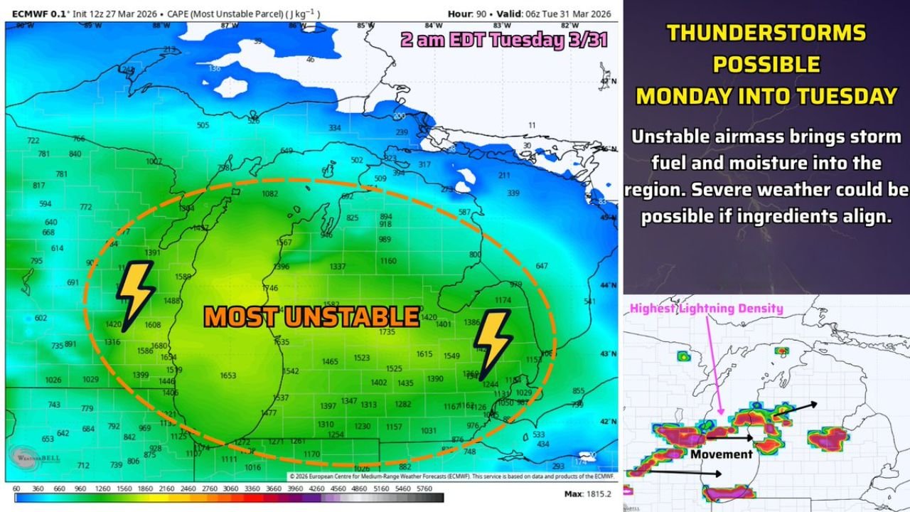
The Fuel Is Already in Place — And It Is Significant
The ECMWF 0.1° ensemble, initialized 12z March 27, 2026, is showing a striking picture of atmospheric instability across Michigan and the surrounding Great Lakes region. Valid at 06z Tuesday, March 31 — that is 2 a.m. EDT — the Most Unstable CAPE (Convective Available Potential Energy) values across the core of the state are telling a clear story.
Key CAPE values from the ECMWF map:
- Most unstable core zone — Lower Michigan: CAPE values ranging from 1,391 to 1,815 J/kg across the heart of the state
- Peak value recorded: 1,815.2 J/kg — well into significant thunderstorm territory
- Western Michigan corridor: Values of 1,420 to 1,694 J/kg — deep within the “most unstable” zone flagged on the map
- Southern Michigan into the Indiana border region: Running 1,157 to 1,465 J/kg
- Eastern Michigan near the Lake Huron shoreline: Moderate instability of 800 to 1,160 J/kg
To put those numbers in perspective — anything over 750 J/kg in the spring is sufficient fuel for stronger thunderstorms. Michigan’s atmosphere is not sitting at 750. It is nearly double that threshold in the most unstable zones. The atmosphere is not just loaded — it is overloaded.
What Is CAPE and Why Does It Matter for You
Think of CAPE like fuel in a gas tank. The more fuel the atmosphere carries, the stronger and longer-lasting storms can become. When a warm, moist airmass moves in and the atmosphere becomes unstable — like heating the inside of a sealed car on a hot day — that energy has to go somewhere. It goes vertical. Fast. That vertical energy release is what powers thunderstorms, and with values approaching 1,800 J/kg, Michigan’s atmosphere is primed.
The ECMWF map is also showing highest lightning density concentrated across the southern Lower Peninsula, with storm movement tracking from southwest to northeast — directly through the most populated corridors of the state.
Timing: Monday Into Early Tuesday Is the Window to Watch
Here is the timeline as it stands right now:
- Monday, March 30 — Daytime: Warm and moist airmass continues advancing into Michigan from the south and southwest. Atmosphere continues loading.
- Monday evening into overnight: Thunderstorm initiation likely as instability peaks and forcing increases. A few storms could become strong.
- 2 a.m. EDT Tuesday, March 31: ECMWF valid time — atmosphere at peak instability. This is the most critical window.
- Early Tuesday morning: Storm system continues tracking northeast, clearing conditions possible by mid-morning.
The late Monday into early Tuesday overnight window is the one to watch most closely.
Severe Weather: Low Probability — But Not Zero
Here is the honest assessment of the data as it stands today. The chances of severe weather remain low — but they are not off the table. For storms to cross the severe threshold, additional ingredients need to align alongside the instability already in place:
- Wind shear — directional change of winds with height to organize storms
- Lift — a frontal boundary or low pressure system to trigger storm initiation
- Moisture depth — sustained moisture through a deep layer of the atmosphere
The ECMWF is showing the fuel. Whether the remaining ingredients come together will determine whether this stays as a garden-variety thunderstorm event or escalates into something that requires warnings. That determination will sharpen significantly over the next 48 to 72 hours as the pattern comes into better model resolution.
Model Confidence Snapshot
| Parameter | ECMWF Reading | Threshold | Status |
|---|---|---|---|
| Most Unstable CAPE | 1,391–1,815 J/kg | 750 J/kg | ⚠️ Well Exceeded |
| Peak Instability Zone | Lower Michigan | Statewide | ⚠️ Core Confirmed |
| Lightning Density | High — Southern LP | Moderate | ⚠️ Elevated |
| Severe Threshold | Low — not yet met | All ingredients | 🔵 Monitoring |
What This Means State by State
- Lower Michigan (Core Zone) — Highest instability values in the entire dataset. Primary target for thunderstorm development Monday night. Monitor closely.
- Western Michigan — Grand Rapids to Kalamazoo corridor — Sitting inside the most unstable zone with CAPE values of 1,600+ J/kg. Storms firing here could be the strongest of the event.
- Southern Michigan — Detroit metro to Ann Arbor — CAPE values of 1,100 to 1,400 J/kg. Thunderstorms likely, strong cells possible depending on shear alignment.
- Upper Peninsula — Instability values drop sharply north of the Straits. Mostly below 500 J/kg. Minimal thunderstorm threat for this event.
Bottom Line: Stay Weather Aware Through Tuesday Morning
Michigan’s atmosphere is being loaded with serious thunderstorm fuel heading into the final days of March. The ECMWF data is not subtle — 1,800 J/kg of instability does not sit quietly. Thunderstorms are coming Monday into Tuesday. The question of severity is still being answered by the models, and that answer will become clearer as the weekend closes out.
Do not wait until Monday to pay attention. Whether you are commuting late Monday night, have outdoor plans, or manage operations across the Lower Peninsula — this is the system to track closely over the next 48 hours.
Data Source: ECMWF 0.1° Ensemble CAPE (Most Unstable Parcel) — Initialized 12z March 27, 2026 | Valid 06z March 31, 2026
Follow ChicagoMusicGuide.com for More Weather Updates
Stay one step ahead of every major storm system. Follow ChicagoMusicGuide.com on NewsBreak for real-time breaking weather analysis, CAPE data breakdowns and severe weather alerts across Michigan and the entire United States — delivered straight to your feed before the storm arrives.