
Michigan Freezing Rain Threat Could Create Dangerous Ice Conditions Across Lower Peninsula on Friday, December 26
MICHIGAN — A significant winter weather event is shaping up across the Lower Peninsula of Michigan on Friday, December 26, as freezing rain, sleet, snow, and rain combine to create widespread icy conditions and hazardous travel, according to forecast data and ice accumulation outlooks from regional meteorologists.
Forecasters warn that freezing rain will likely accumulate on untreated roads, sidewalks, trees, and power lines, especially from west to east through the central portion of the state, as a low-pressure system moves in after midnight Thursday night and intensifies through Friday.
Freezing Rain and Ice Accumulation Details
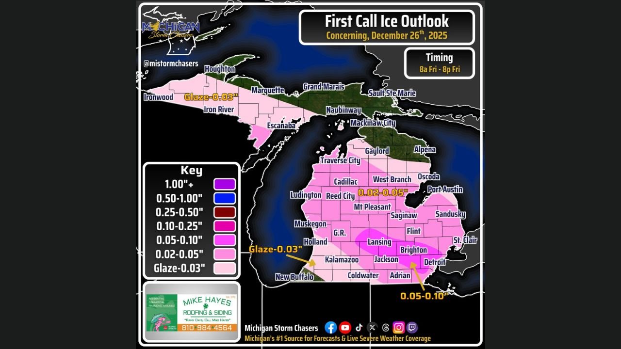
Forecast guidance indicates freezing rain splitting the state nearly down the middle, with the most impactful icing expected along and south of the I-96 corridor, particularly in southeastern Michigan.
Ice accretion rates may reach 0.025 to 0.05 inches per hour, with localized totals approaching 0.1 inch possible in the hardest-hit areas. Even light ice accumulation at these levels can create extremely slick road conditions and increase the risk of vehicle accidents and power disruptions.
Areas of concern include:
- Grand Rapids
- Lansing
- Kalamazoo
- Jackson
- Detroit metro
- Ann Arbor
- Brighton
- Flint
- Saginaw Valley communities
Precipitation Type Breakdown Across Michigan
The storm will feature multiple precipitation types, varying by location:
- Northern Michigan: Snow and sleet dominate, with colder surface temperatures.
- Central Michigan: A mix of sleet and freezing rain, with rapid ice accumulation.
- Southern and Southwest Michigan: Periods of rain, though freezing rain is possible early before temperatures rise slightly.
Elevated instability within the system may even produce isolated thunder or small hail, especially within sleet and freezing rain bands—an unusual but possible scenario given atmospheric conditions.
Travel Impacts and Timing
Travel conditions are expected to deteriorate rapidly Friday morning, with impacts beginning:
- As early as 8 a.m. EST in West Michigan
- Statewide by midday Friday
Because surface temperatures are forecast to remain below freezing even after precipitation tapers, icy roads may persist Friday night into Saturday, especially on untreated secondary roads and bridges.
Motorists are urged to avoid unnecessary travel, reduce speed, and prepare for sudden loss of traction.
Temperature Outlook
Temperatures will remain well below normal:
- Southern Michigan: Highs mainly in the low to mid-30s
- Southwest Michigan: Briefly near 40°F
- Northern Lower Peninsula: 20s, limiting melting potential
With colder air firmly in place, little improvement in road conditions is expected until Saturday.
What Residents Should Do Now
- Delay travel if possible, especially Friday morning and afternoon
- Treat walkways and driveways ahead of time
- Prepare vehicles with emergency supplies
- Monitor local advisories and real-time updates
Officials stress that conditions could change quickly depending on the exact placement of heavier ice bands.
What’s Next
Forecast confidence continues to improve, but band placement may still shift, which could change which communities see the worst icing. Residents should remain alert and prepared as additional updates are issued.
Stay tuned for continuing weather coverage and safety updates right here on ChicagoMusicGuide.com, as we track major weather threats impacting communities across the Midwest and beyond.