
Michigan, Indiana and Ohio Are Being Watched for Severe Thunderstorms Tuesday Afternoon and Evening With a Large Storm Corridor Stretching From Arkansas Into Pennsylvania
DETROIT, MI — Tuesday is shaping up to be a day worth watching closely across a broad stretch of the eastern United States. Severe thunderstorms are possible Tuesday afternoon through evening hours across a corridor covering multiple states from the southern Plains all the way northeast into the Great Lakes and Pennsylvania. For residents across Michigan, Indiana, Ohio and Illinois, this is not a threat to panic over right now — but it is absolutely one to stay informed about as the day approaches.
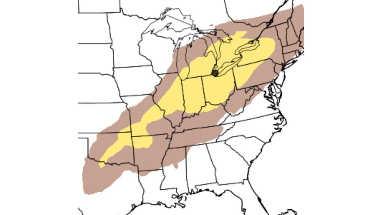
What the Current Outlook Is Showing
The latest severe weather outlook map is painting a two-tier risk zone across the eastern half of the country for Tuesday’s storm potential. Two distinct shaded areas tell the geographic story of this setup.
The yellow zone — representing the higher-confidence portion of the severe weather risk — covers the core of the threat area. This zone stretches from southern Illinois and Missouri northeastward through Indiana, Ohio and into southern Michigan and western Pennsylvania. This is where organized severe thunderstorm development is considered most likely during the Tuesday afternoon and evening window if the atmosphere cooperates.
The brown zone — a broader, more uncertain severe weather area — extends the potential risk outward in all directions from that yellow core. It reaches from Arkansas and Missouri in the southwest all the way northeast through Michigan’s Lower Peninsula, northern Ohio, Pennsylvania and into New York. This zone represents real but lower-confidence severe weather potential across a very large geographic footprint.
Together, these two zones cover millions of people across the Midwest, Great Lakes and Appalachian corridor — and the fact that the yellow core sits directly over some of the most populated parts of the region makes Tuesday a day that demands attention.
The Honest Truth: Low Confidence Right Now
Here is where this forecast requires complete honesty. A lot of uncertainty exists with this setup — and that uncertainty is the reason the threat has not been elevated to a higher-confidence severe weather outlook at this time.
Low confidence in a severe weather forecast does not mean the storms will not happen. It means the atmospheric ingredients have not yet aligned clearly enough to say with high certainty that organized severe thunderstorms will develop, and exactly where the greatest threat will be located. The window for Tuesday’s storms to come together — or not come together — will depend on several factors that will sharpen significantly over the next 24 to 48 hours.
What the current data supports is this: the pattern is capable of producing severe thunderstorms across the outlined area. Whether it delivers on that potential is the question that Tuesday’s atmosphere still needs to answer.
Tuesday Storm Threat Outlook Table
| Zone | States Included | Threat Level | Confidence |
|---|---|---|---|
| Yellow — Core Risk | Indiana, Ohio, S. Michigan, SW Pennsylvania, S. Illinois | 🟡 Severe Possible | Low |
| Brown — Broader Risk | Arkansas, Missouri, Michigan, New York, Tennessee | 🟤 Marginal Severe | Very Low |
| Timing | Tuesday afternoon into evening | Peak window 2 PM to 10 PM | Low-Moderate |
| Primary Threats | Damaging winds, hail, isolated tornado | All hazards possible | Low |
| Overall Confidence | Uncertainties remain high | Updates Tuesday AM critical | 🟡 Low |
Where Each State Stands for Tuesday
🟡 Indiana — Sitting squarely inside the yellow core risk zone. Indianapolis through Fort Wayne and South Bend are all within the higher-confidence severe weather area for Tuesday. Damaging winds and large hail are the primary threats with any organized storm that develops.
🟡 Ohio — Columbus, Cleveland and Cincinnati all fall within or immediately adjacent to the yellow severe weather zone. The Tuesday afternoon and evening window is the critical period for Ohio residents to monitor.
🟡 Michigan — Lower Peninsula — Detroit, Lansing and Grand Rapids sit inside the broader brown risk zone with portions of southern Michigan touching the yellow core area. Tuesday evening is the most likely timing for any storm activity reaching the Michigan border.
🟡 Illinois — Southern and Central — The southwestern edge of the yellow zone clips Springfield and the St. Louis metro area on the Illinois side. Storm potential exists here but the confidence is lower than for Indiana and Ohio.
🟤 Arkansas and Missouri — Inside the broader brown zone. Severe thunderstorm potential exists but confidence is the lowest of any state in the outlined area.
🟤 Pennsylvania and New York — On the northeastern fringe of the brown zone. Any storms that develop in the Ohio Valley could track northeast into western Pennsylvania and New York during the Tuesday evening hours.
🟢 Southeast — Alabama, Georgia, Carolinas — Outside the outlined risk area for Tuesday’s storm system. No organized severe weather threat from this setup for the Deep South.
What You Should Be Doing Right Now
The most important action for anyone in Indiana, Ohio and southern Michigan right now is simple — keep Tuesday on your radar and check back for updates Monday and Tuesday morning. The confidence level on this setup will rise or fall significantly with each model run between now and Tuesday afternoon.
If you have outdoor plans for Tuesday afternoon or evening anywhere in the yellow or brown zones, keep a flexible mindset and have a plan for shelter. Severe thunderstorms can develop and move quickly, and the afternoon into evening timing means many people will be commuting, at outdoor events or away from home when storms could be at their most active.
Make sure weather alerts are active on your phone before Tuesday arrives. A Severe Thunderstorm Watch issued ahead of Tuesday’s storm window will be your first signal that the atmosphere is delivering on its potential — and that is the time to sharpen your situational awareness significantly.
Tuesday Is Not the Last Storm Day This Week Across the Midwest and Great Lakes
More storm systems are lined up behind Tuesday across Michigan, Indiana and Ohio. Stay informed at ChicagoMusicGuide.com — your source for daily severe weather updates, storm timing forecasts and outbreak coverage across the Great Lakes, Midwest and the entire United States.