
Michigan, Wisconsin, Minnesota, Illinois, Indiana, Ohio, Pennsylvania and New York Face Late-January Heavy Snow Risk, CPC Outlook Shows
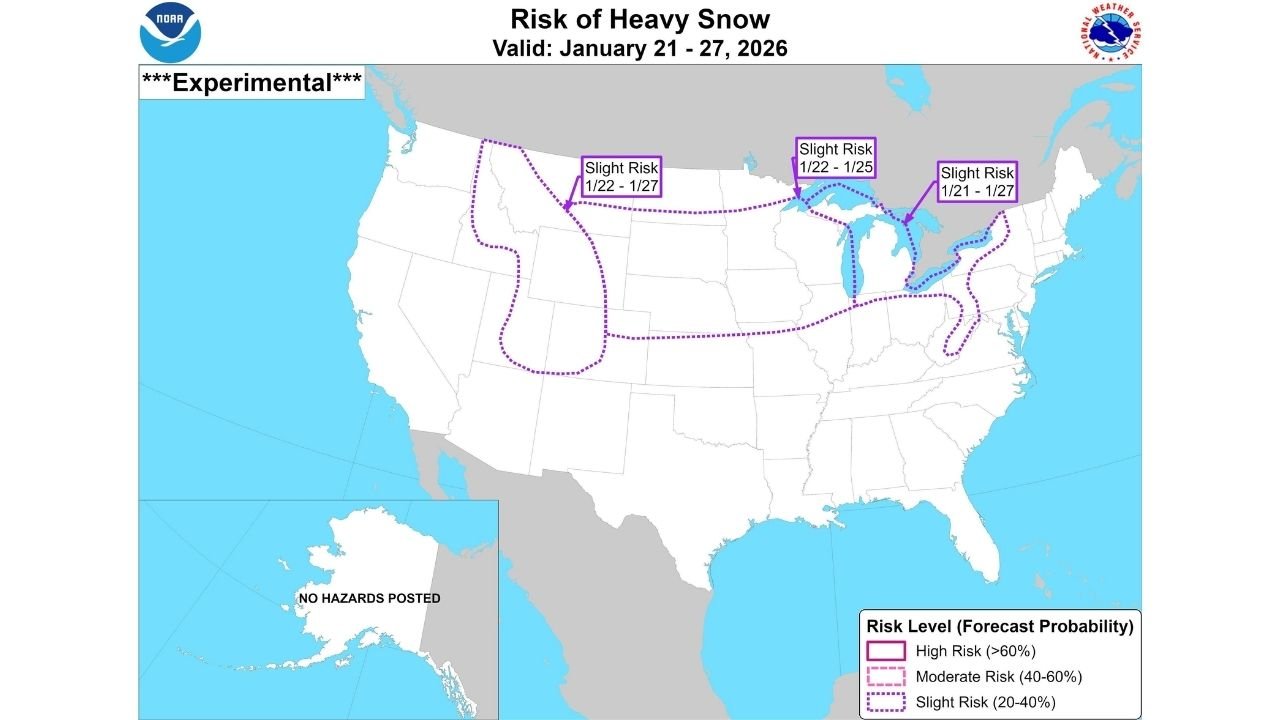
MIDWEST & GREAT LAKES – An experimental outlook from NOAA’s Climate Prediction Center (CPC) is flagging an increasing risk of heavy snow for the January 21–27, 2026 window, with the most notable “slight risk” areas centered on the Midwest and Great Lakes, including parts of Michigan, Wisconsin, Minnesota, Illinois, Indiana, and Ohio, and stretching into Pennsylvania and New York.
What the CPC map is actually saying (and what it isn’t)
The CPC graphic is labeled “Experimental” and shows Slight Risk (20–40%) zones for heavy snow during specific parts of the Jan. 21–27 period. This is not a city-by-city snowfall forecast and it does not mean everyone inside the outlined area will get a major storm. What it does mean is:
- The pattern is becoming more supportive of at least one meaningful snow event somewhere inside the risk area.
- Confidence is higher than normal for the time range, but the exact storm track and totals are still uncertain.
- The “risk window” can change as newer model runs come in.
Where the late-January snow signal is strongest right now
Based on the outlined areas on the CPC outlook, the Great Lakes corridor is one of the standout zones. That includes:
- Upper Midwest into the Great Lakes: parts of Minnesota and Wisconsin into Michigan
- Great Lakes into the interior East: parts of Indiana and Ohio extending toward Pennsylvania and New York
- Additional “slight risk” zones also appear in the western U.S. (a separate outlined region), which suggests the broader pattern could support multiple storm corridors nationwide during this stretch.
Why this matters even before exact totals are known
When a late-range outlook highlights heavy snow potential, the practical takeaway is preparation for travel disruption and schedule impacts, especially in regions that can flip from “quiet winter” to “high-impact week” fast.
For people across the Midwest and Great Lakes, the biggest early heads-up issues tend to be:
- Commute problems: rapid deteriorations during heavier bands
- Airport and rail delays: cascading delays when multiple hubs are affected
- Road treatment timing: heavier bursts can outpace plows, especially overnight
- Power and tree impacts: mainly if snow turns wetter/heavier in parts of the region
What could change the forecast quickly
This type of outlook can sharpen or shift depending on how the upper-air pattern evolves. The main things to watch as we get closer to Jan. 21–27:
- Whether storm tracks favor a Great Lakes cutter, a southern-track system, or a Ohio Valley/Appalachians path
- If cold air stays locked in, which increases the chance that precipitation falls as snow instead of rain or mix
- Whether the heaviest snow threat focuses more on lake-enhanced corridors (downwind of the Great Lakes) versus a synoptic storm with a broader swath
How to use this outlook the smart way
If you’re in Michigan, Wisconsin, Minnesota, Illinois, Indiana, Ohio, Pennsylvania, or New York, this is a good time to do the basics before the higher-confidence forecasts arrive:
- Check your vehicle: tires, wipers, windshield fluid, and a small emergency kit
- Plan flexibility for travel days in the Jan. 21–27 window
- Make sure alerts are enabled for your local NWS office
- If you manage events, venues, or staffing, consider a “weather contingency” plan for that week
If you’re tracking winter weather updates and how they could affect travel, concerts, and regional schedules, share what you’re seeing where you live — and follow along for updates at ChicagoMusicGuide.com.