Mid-Atlantic Snowfall Reports Show Sharp Local Variations as Sunday Storm Drops 1–4.5 Inches Across the Region

Mid-Atlantic — A Fast-Moving Winter System Produces Highly Variable Snow Totals, A quick-moving snowstorm crossed the Mid-Atlantic on Sunday, leaving behind sharply inconsistent snowfall totals that ranged from just 1 inch in some areas to over 4 inches in localized bands. The most dramatic variations were observed across the Baltimore metro region, where official totals at BWI Airport were significantly lower than surrounding communities.
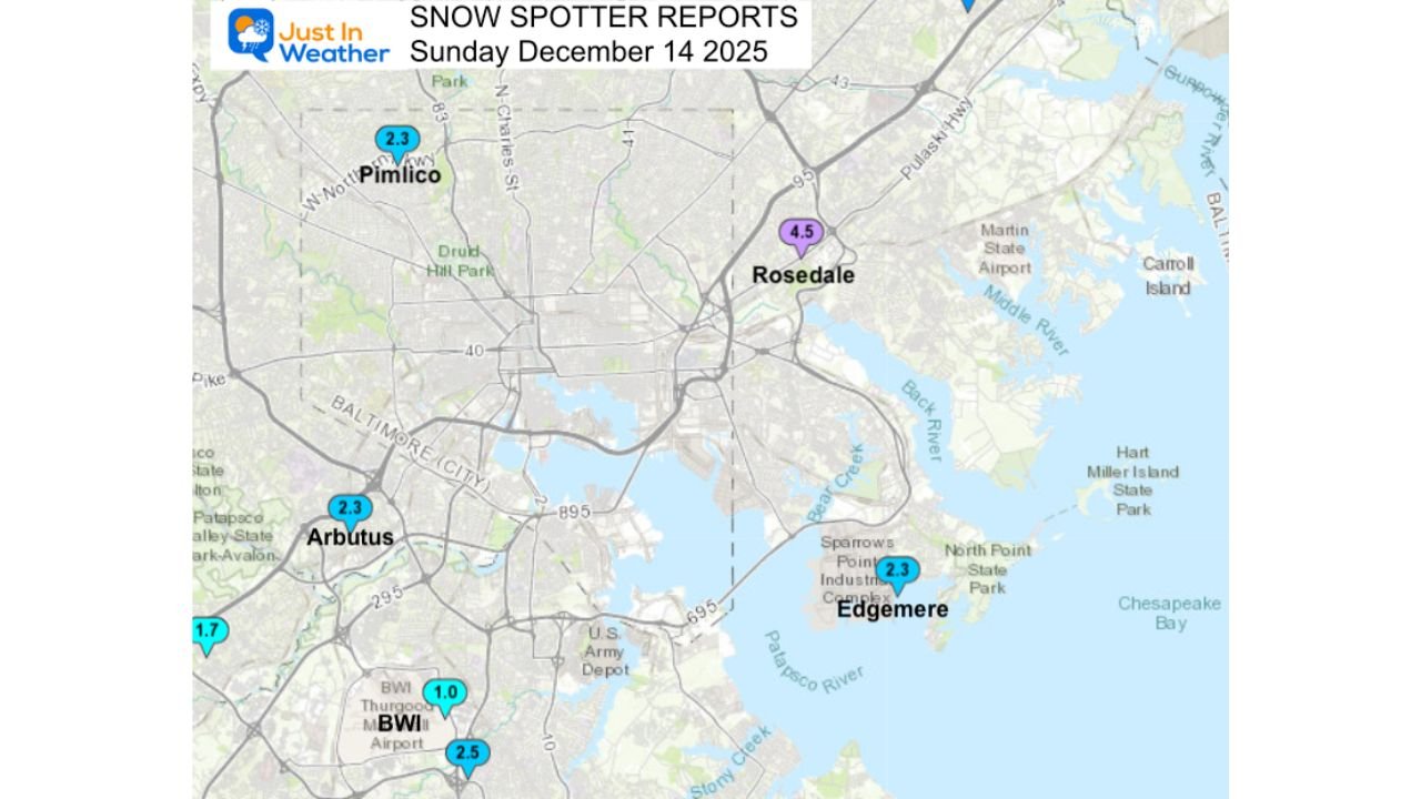
Snow spotter data from December 14 highlights how narrow bands of heavier snow developed during the storm, creating stark differences over very short distances.
Baltimore Metro Sees Largest Variability in Totals
Reports across central Maryland show a clear split between lighter accumulations near BWI and heavier totals toward the northeast suburbs.
Notable snowfall measurements include:
- Rosedale — 4.5″
- Pimlico — 2.3″
- Arbutus — 2.3″
- Edgemere — 2.3″
Despite these higher amounts, BWI registered only 1.0 inch, illustrating how the storm’s narrow, intense snow bands bypassed the airport while impacting neighborhoods just miles away.
This type of pattern is common in the Mid-Atlantic, where small-scale atmospheric features can sharply influence snowfall distribution.
Suburban Communities Report Moderate Accumulations
Areas surrounding Baltimore saw lighter but still meaningful snow totals, generally between 1 and 3 inches.
Confirmed reports include:
- Elkridge — 2.0″
- Hanover — 1.7″
- Ellicott City — 2.3″
- Simpsonville — 1.6–3.0″ (depending on elevation)
These amounts reflect steady, moderate snowfall beneath broader storm bands, with minor enhancement in locations slightly above sea level.
Anne Arundel County and Chesapeake Bay Region Totals
Moving southeast toward the Chesapeake Bay, snowfall tapered slightly but remained measurable across coastal and inland communities:
- Annapolis — 2.0″
- Crofton — 2.2″
- Odenton — 2.3″
- Bowie — 1.8″
- Chelsea Beach — 1.5″
Warmer marine-influenced air contributed to lower totals in these areas, keeping the heaviest snow farther inland.
Why Snow Totals Varied So Dramatically
Meteorologists attribute the uneven snowfall to mesoscale snow bands — narrow corridors of enhanced precipitation that develop during rapidly evolving winter systems. These bands often produce heavier snow in isolated areas while nearby locations receive much less.
Other contributing factors included:
- Slight elevation differences across central Maryland
- Local temperature variations near the Bay
- Sharp gradients behind the storm’s coastal trough
Such features routinely create challenging forecasting conditions in the Mid-Atlantic during early-season storms.
What Comes Next for the Mid-Atlantic
Forecasters continue monitoring additional potential systems for later in the week. While no major storms are currently expected, colder temperatures and light precipitation remain possible as winter patterns strengthen across the region.
Residents are encouraged to keep updated forecasts handy, especially for travel across the Baltimore–Washington corridor, where micro-climate variations can significantly affect road conditions.
Stay Informed With ChicagoMusicGuide.com Weather Updates
Stay tuned to ChicagoMusicGuide.com for continuing Mid-Atlantic weather coverage, detailed snowfall reports, and updates on upcoming winter systems as the season progresses.
