
Midwest and Southern Plains Warm Surge Builds as Texas, Oklahoma, Missouri, and Illinois Trend Above Average Into Late February
UNITED STATES — A broad warming pattern is taking shape across much of the Lower 48, with Texas, Oklahoma, Kansas, Missouri, and Illinois trending above average through this week and into next week, according to the latest Week 1 and Week 2 temperature anomaly outlooks. Meanwhile, both the West Coast and parts of the East Coast are expected to remain near or below seasonal averages, setting up a sharp national temperature contrast.
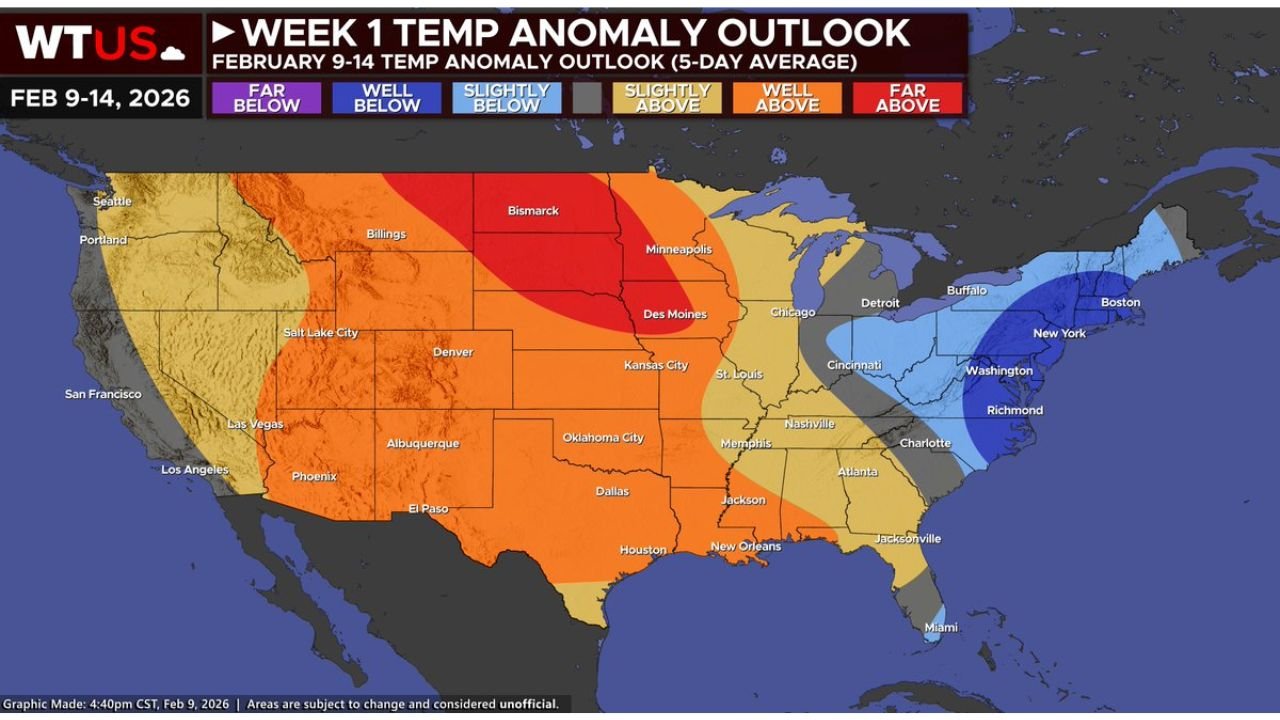
Above-Average Temperatures Expand Across the Central U.S.
The latest outlook shows a large swath of above-average temperatures building from the Southern Plains into the Midwest, covering Texas, Oklahoma, Kansas, Missouri, Iowa, and Illinois. In both Week 1 (Feb 9–14) and Week 2 (Feb 14–19), these regions are consistently shaded in slightly to well-above average categories, signaling a sustained warm pattern rather than a brief spike.
Cities such as Dallas, Oklahoma City, Kansas City, St. Louis, and Chicago fall within the core of this warmer air mass. This pattern supports daytime highs running several degrees above normal, particularly across the Central Plains and Mississippi Valley, with fewer intrusions of Arctic air compared to earlier in the winter.
West and East Coasts Stay Cooler by Comparison
While the center of the country warms, both coasts tell a different story. The West Coast, including California, Oregon, and Washington, remains closer to near-average or slightly below-average temperatures, supported by continued troughing along the Pacific.
On the East Coast, cooler air persists from New England through parts of the Mid-Atlantic, including New York, Massachusetts, and coastal New England, where temperature anomalies remain neutral to below normal. This contrast highlights the developing ridge across the interior U.S. versus troughing on both flanks.
Pattern Drivers: PNA, AO, and NAO Aligning
The developing temperature pattern is supported by a positive-leaning PNA (-PNA evolving toward neutral) combined with a near-neutral AO and NAO. This setup promotes troughing in the West while allowing ridging to build across the Central and portions of the Eastern U.S.
As ridging strengthens, cold air is effectively displaced northward, reducing the frequency of deep winter intrusions into the Midwest and Southern Plains. This alignment favors prolonged mild stretches rather than short-lived warmups.
Rainfall and Storm Potential Increases for the Southern Plains and Mid-South
In addition to warmer temperatures, the pattern also supports above-average precipitation across parts of the Southern Plains and Mid-South, including Texas, Oklahoma, Arkansas, Tennessee, and Mississippi, beginning this weekend and extending into next week.
With warmer air returning and Gulf moisture increasing, strong to potentially severe thunderstorms cannot be ruled out, especially where frontal boundaries stall beneath the ridge-trough transition zone. While specifics on timing and intensity remain uncertain, the setup favors an active weather corridor across the southern half of the country.
What This Means Moving Toward Late February
For much of the Central U.S., including Illinois, this pattern suggests a less wintry and more spring-like feel as February progresses. While brief cold snaps remain possible, the broader signal favors above-normal temperatures dominating the remainder of the month.
At the same time, increased precipitation and storm chances across the Southern Plains and Southeast highlight the need to stay weather-aware as the transition toward early spring accelerates.
For ongoing weather updates, long-range outlooks, and regional breakdowns that matter to music fans, travelers, and event planners alike, keep checking back with ChicagoMusicGuide.com, your source for weather conditions impacting concerts, festivals, and live events across the country.