
Midwest Storm System Threatens Wisconsin, Michigan, Indiana, and Kentucky With Heavy Snow, Ice, and Tornadoes From Sunday Into Monday
WISCONSIN — A powerful and complex storm system is sweeping across the Midwest this weekend, setting up dangerous and rapidly changing weather conditions from Sunday afternoon through Monday. Forecast data and warning maps show multiple high-impact hazards unfolding at the same time — including heavy snow and blizzard-like conditions in Wisconsin, damaging ice and wind in Michigan, and active tornado warnings across parts of Indiana and Kentucky.
Forecasters stress that this is not a single-threat storm. Instead, it is a multi-hazard system capable of disrupting travel, power, and public safety across several states within a short time window.
Heavy Snow and Blizzard Conditions Focus on Wisconsin
Northern and central Wisconsin are expected to take the brunt of the winter side of this system. Snowfall projections indicate widespread totals of 4–6 inches, with higher amounts of 8–12 inches possible across northern counties, especially along and north of Highway 8.
Strong northwest winds of 20–30 mph, with gusts reaching 35 to 50 mph, are forecast to accompany the snow. These winds will create blowing and drifting snow, sharply reducing visibility and making roads hazardous, particularly Sunday night into Monday morning.
A Winter Storm Warning has been issued for the entire forecast area served by NWS Green Bay, highlighting the likelihood of rapidly deteriorating travel conditions.
Ice Storm and Falling Trees Threaten Central Michigan
In Michigan, especially Clare County and surrounding areas, the concern shifts from snow to significant ice accumulation. Forecast data shows 0.25 to 0.50 inches of freezing rain already coating trees and power lines — ice that is not expected to melt before the storm intensifies.
As the system strengthens, 40–50+ mph wind gusts combined with several inches of snow will add dangerous stress to ice-laden trees. Meteorologists warn this combination could lead to widespread tree failures, downed power lines, and extended power outages.
Officials describe the situation as “very dangerous,” urging residents to avoid travel and prepare for possible infrastructure damage.
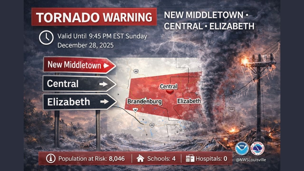
Tornado Warnings Active Across Kentucky and Southern Indiana
While winter weather dominates to the north, the southern edge of the storm is producing severe thunderstorms and tornado warnings across parts of Kentucky and Indiana.
Active warnings have included:
- Henderson, Corydon, and Spottsville, Kentucky
- Brandenburg and West Point, Kentucky
- Elizabeth, New Middletown, and Central, Indiana
These warnings are radar-indicated and include the potential for brief tornadoes and pea-sized hail. Populated areas within the warning polygons include thousands of residents, multiple schools, and key road corridors. Warnings remain time-sensitive, with expiration windows extending into the late evening.
Residents in these areas are urged to seek shelter immediately when warnings are issued and remain alert for rapid updates.
A Sharp Temperature Crash Follows the Storm
Adding to the danger is a dramatic temperature whiplash behind the system. Portions of the Ohio Valley may see Sunday highs in the 60s, followed by Monday highs plunging into the 20s as Arctic air surges south.
This rapid drop will cause flash freezing, especially on wet roadways left behind by rain or melting snow, compounding travel risks well after precipitation ends.
What This Means for Travelers and Events
With snow, ice, severe storms, and extreme temperature changes all occurring within the same system, impacts are expected to be widespread and disruptive. Travel delays, power outages, and last-minute event cancellations are possible across the region.
Weather officials strongly advise residents across Wisconsin, Michigan, Indiana, and Kentucky to:
- Monitor local alerts closely
- Avoid unnecessary travel during peak storm periods
- Prepare for power outages
- Have multiple ways to receive emergency warnings
For music fans and event-goers across the Midwest, this is a weekend to prioritize safety over schedules.
Stay connected with ChicagoMusicGuide.com for continued regional updates, safety information, and how this evolving storm system could impact travel and live events across the Midwest.