
Minneapolis, Duluth and Green Bay Brace for Heavy Snow and Ice as Late-Season Winter Storm Sweeps Upper Midwest and Great Lakes
MINNEAPOLIS, MINNESOTA — A powerful late-season winter storm is impacting parts of the Northern Plains, Upper Midwest, and Great Lakes, bringing heavy snowfall, dangerous icing, and hazardous travel conditions from cities like Minneapolis and Duluth to Green Bay and northern Michigan.
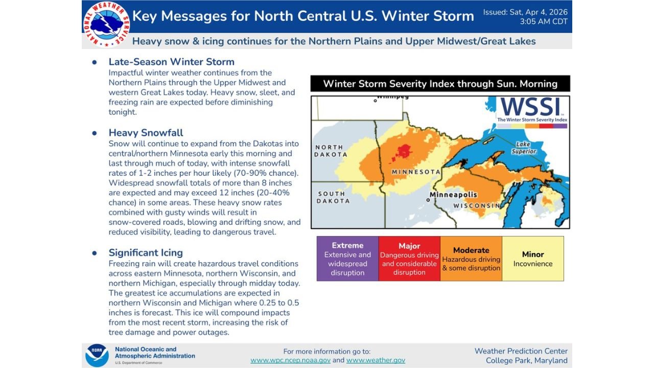
Forecast data shows this system will continue through today, with significant impacts expected before conditions begin to improve later tonight.
Heavy Snow Expands Across Minnesota and the Dakotas
The storm is producing widespread heavy snowfall across North Dakota, South Dakota, and Minnesota, with the heaviest band centered near:
- Minneapolis and central Minnesota
- Extending toward northern Wisconsin
Snowfall rates are expected to reach:
- 1 to 2 inches per hour in the heaviest bands
- A 70–90% chance of intense snowfall rates during peak periods
Total accumulations are forecast to exceed:
- 8 inches across large portions of Minnesota
- Potentially over 12 inches in localized areas
These conditions are leading to:
- Snow-covered and slick roadways
- Blowing and drifting snow due to gusty winds
- Rapidly reduced visibility for drivers
Travel across cities like Minneapolis, St. Cloud, and Duluth is expected to become increasingly dangerous throughout the day.
Significant Ice Threat Targets Wisconsin and Michigan
While heavy snow dominates farther west, areas to the east are dealing with a serious icing threat, particularly across:
- Northern Wisconsin
- Northern Michigan
- Portions of eastern Minnesota
Freezing rain is expected to create:
- Ice accumulations between 0.25 and 0.50 inches
- Extremely hazardous road conditions
- Elevated risk of tree damage and power outages
Cities such as Green Bay, Marquette, and surrounding communities are in the zone where icing impacts could be most severe, especially through midday.
This ice buildup is particularly concerning as it is compounding effects from previous storms, increasing the likelihood of infrastructure damage and prolonged outages.
Winter Storm Severity Index Highlights Major Impacts
The Winter Storm Severity Index (WSSI) indicates a broad area of:
- Moderate to Major impacts across Minnesota and Wisconsin
- Localized zones approaching higher-end disruption levels
These impacts include:
- Dangerous driving conditions
- Travel delays and cancellations
- Widespread disruptions to daily activities
The combination of heavy snow in the west and ice in the east is creating a multi-hazard event, making this storm particularly dangerous across multiple states.
Conditions Expected to Improve Later Tonight
The system is forecast to gradually weaken and move out of the region by late evening into the overnight hours.
However, even after precipitation ends:
- Road conditions will remain hazardous
- Lingering ice and snowpack will continue to impact travel
- Cleanup efforts may take several days in the hardest-hit areas
Residents across Minnesota, Wisconsin, and Michigan are advised to limit travel, monitor local updates, and prepare for continued winter conditions despite the late-season timing.
This storm serves as a reminder that winter weather risks can persist well into spring across the Upper Midwest and Great Lakes.
For more updates on winter storms, severe weather alerts, and regional forecasts, visit ChicagoMusicGuide.com and stay informed as conditions continue to evolve.