
Minneapolis St. Paul and Western Wisconsin Face Uncertain Snow Potential Saturday as Storm Track Remains in Question
MINNESOTA — Weather models are showing a sharp disagreement over a potential snow event next Saturday that could impact the Minneapolis–St. Paul metro (MSP) and parts of western and central Wisconsin, with outcomes ranging from minimal snowfall to a more disruptive winter system depending on storm track.
Forecast guidance shows an “all or nothing” setup, where small shifts in the storm’s path could mean the difference between light snow or several inches for the Twin Cities region.
American and Canadian Models Keep Storm Well South
Current American (GFS) and Canadian model solutions track the developing system well south of MSP, with the primary snow band staying across southern Iowa and far southern Minnesota.
Under these scenarios, snowfall totals across the Twin Cities would remain minimal to near zero, with most accumulating snow confined to areas south of the Minnesota–Iowa border. Northern Iowa appears favored for the heavier swath in these model runs.
This solution would leave much of central and northern Minnesota dry, with only light or scattered snow possible near the southern edge of the state.
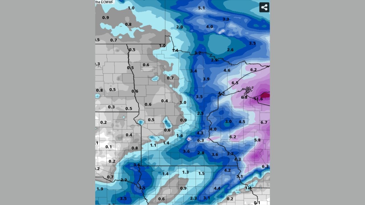
European Model Brings Snow Into MSP and Wisconsin
In contrast, the European (ECMWF) model paints a notably different picture.
Its solution lifts the storm farther north, bringing measurable snowfall into the Minneapolis–St. Paul metro and extending accumulations eastward into Wisconsin. Several ECMWF runs indicate a broader snow shield, suggesting a more organized winter system rather than a glancing blow.
This northward shift would place MSP closer to the deformation zone, increasing the potential for moderate accumulations, particularly if colder air locks in during the event.
Why This Setup Is High-Risk and High-Uncertainty
This forecast hinges on small-scale track differences that remain unresolved at this range:
- A slight southward track keeps snow mostly in Iowa
- A slight northward shift pulls the snow band directly over MSP
- Timing of cold air arrival will determine snow efficiency
- Jet stream placement will influence how far north precipitation expands
Because of these factors, confidence remains low — but the potential impact is high if the European solution verifies.
What to Watch Over the Next Few Days
Forecasters will be watching for:
- Better agreement between model families
- Consistency in ECMWF runs
- Whether newer GFS updates trend north
- Stronger signals of cold air alignment with precipitation
Until then, this remains a classic “stay tuned” winter setup for Minnesota and Wisconsin.
If you’re in the Twin Cities or western Wisconsin, now is the time to keep an eye on updated forecasts as this system comes into clearer focus. Share your thoughts, snowfall expectations, or local observations, and follow ongoing weather coverage at ChicagoMusicGuide.com.