
Minnesota and Wisconsin Face Enhanced Risk of Large Hail and Tornadoes Tomorrow While Northern Texas and Oklahoma Watch a Conditional Dryline Threat From Oklahoma City and Dallas to Wichita Falls
MINNEAPOLIS, MN — Two separate severe weather corridors are taking shape for tomorrow across the United States — one well-defined and officially upgraded, the other conditional but worth watching closely as better moisture and instability build along a critical atmospheric boundary.
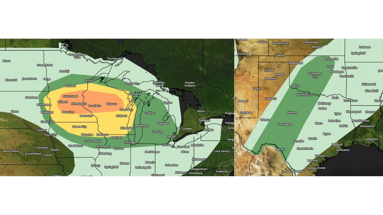
The clearest and most urgent signal belongs to Minnesota and Wisconsin, where the Storm Prediction Center has issued an Enhanced Risk — Level 3 on the five-tier national scale — with large hail and a couple of tornadoes as the primary threats. Meanwhile, across northern Texas and Oklahoma, a marginal risk is in place along the dryline, with storm potential that is higher than today but still dependent on whether sufficient lift materializes to fire supercells.
Minnesota and Wisconsin: The Enhanced Risk Corridor
Current analysis places the Enhanced Risk bullseye across a broad corridor covering central and eastern Minnesota through Wisconsin, with the highest threat concentration centered over Minneapolis, Saint Cloud, Willmar, New Ulm, Rochester, Eau Claire, Wausau, Green Bay, and Oshkosh.
The orange Enhanced zone on the outlook map covers this entire corridor, meaning forecasters have high confidence that organized severe weather will develop across this region tomorrow. The Slight Risk zone expands the threat outward to include Duluth, Brainerd, Waterloo, Dubuque, Rockford, Milwaukee, and the Chicago northern fringe. A broader Marginal zone reaches Sioux Falls, Mason City, Cedar Rapids, Des Moines, and portions of Michigan including Muskegon and Lansing.
Large hail is the headline threat across the Enhanced zone, with stones large enough to damage vehicles, break windows, and injure anyone caught outdoors expected with the most organized supercells. A couple of tornadoes are also possible within the Enhanced corridor, particularly across central Minnesota and central Wisconsin where the atmospheric setup is most favorable for rotating storm development.
Minnesota and Wisconsin Threat Summary
| Risk Level | Cities Included | Primary Threats |
|---|---|---|
| Enhanced (Orange) | Minneapolis, Saint Cloud, Eau Claire, Wausau, Green Bay, Oshkosh, Rochester | Large hail, tornadoes |
| Slight (Yellow) | Milwaukee, Rockford, Dubuque, Duluth, Waterloo | Large hail, damaging winds |
| Marginal (Green) | Sioux Falls, Des Moines, Cedar Rapids, Chicago fringe, Lansing | Isolated severe storms |
Northern Texas and Oklahoma: The Conditional Dryline Watch
The picture across northern Texas and Oklahoma is more nuanced, and current analysis is appropriately measured about what tomorrow holds for this region. The Storm Prediction Center has a marginal risk in place covering a corridor from Woodward and Oklahoma City in Oklahoma southward through Wichita Falls, Abilene, San Angelo, Dallas, Waco, Austin, and San Antonio in Texas.
Unlike today, tomorrow’s setup brings better moisture, instability, and lift along the dryline — the boundary between dry desert air from the west and moist Gulf air from the south — across northern Texas and Oklahoma. This improves the chances of storm initiation compared to today’s largely suppressed environment. However, whether storms actually fire remains conditional. The atmosphere may be better loaded tomorrow, but better loaded does not guarantee ignition.
If storms do develop along the dryline across northern Texas and Oklahoma tomorrow, the environment surrounding them is capable of supporting supercell thunderstorms. Any supercell that organizes in this environment carries the potential for large hail, damaging winds, and an isolated tornado — the standard toolkit of a dryline supercell in the southern Plains in April.
The Slight Risk zone across this map covers a swath from Woodward and Oklahoma City southeast through Wichita Falls, Dallas, and Waco, with a Marginal zone extending the threat to San Antonio, Houston, Galveston, Austin, and east toward Texarkana and Shreveport.
Texas and Oklahoma Threat Summary
| Risk Level | Cities Included | Condition |
|---|---|---|
| Slight (Green darker) | Oklahoma City, Woodward, Wichita Falls, Abilene, Dallas, Waco | Storms conditional on dryline initiation |
| Marginal (Light green) | San Antonio, Austin, Houston, Texarkana, Tulsa, Bartlesville | Isolated storms if supercells develop |
State-by-State Breakdown
Minnesota The highest-risk state in tomorrow’s outlook. The Enhanced zone is centered directly over central and southern Minnesota including Minneapolis, Saint Cloud, Willmar, New Ulm, and Rochester. Large hail and tornadoes are the forecast threats. Residents across this corridor should have shelter plans confirmed before tomorrow afternoon.
Wisconsin Shares the Enhanced zone with Minnesota across the Eau Claire, Wausau, Green Bay, and Oshkosh corridor. Milwaukee sits in the Slight zone. Large hail is the primary threat statewide with tornadoes possible in the Enhanced corridor.
Illinois and Iowa The northern fringe of Illinois including the Rockford and Chicago area sits in the outer Marginal zone. Iowa communities including Waterloo, Dubuque, Des Moines, and Cedar Rapids fall within the Slight to Marginal corridor. Isolated severe storms are possible but widespread severe weather is not the primary expectation here.
Oklahoma A marginal risk covers Oklahoma City, Woodward, Altus, and Tulsa. Storm potential tomorrow is conditional on dryline initiation. If storms fire, supercell potential exists. Current analysis indicates tomorrow has a meaningfully higher chance of storm development than today, but initiation is not guaranteed.
Texas The dryline corridor runs from Wichita Falls south through Abilene, San Angelo, Dallas, Waco, Austin, and San Antonio. A marginal to slight risk covers the majority of the state east of the dryline. Supercell development remains conditional, but if storms fire across north Texas, the environment can support large hail and isolated tornadoes.
Forecast Confidence
Confidence: High for Minnesota and Wisconsin Enhanced Risk. Low to Moderate for Texas and Oklahoma. The Minnesota and Wisconsin Enhanced Risk carries strong institutional backing from the Storm Prediction Center and is well-supported across multiple model runs. The Texas and Oklahoma picture remains genuinely uncertain — the atmosphere is better positioned than today, but storm initiation along the dryline is not locked in and the situation will become clearer through tomorrow morning’s data trends.
More severe weather coverage is always on the horizon. Stay informed at ChicagoMusicGuide.com — your source for tornado and hail tracking across Minnesota, Wisconsin, Oklahoma, Texas, and the entire United States.