
Minnesota, Wisconsin, Michigan, and New York Face Hazardous Cold and Heavy Snow Risk From January 20–24
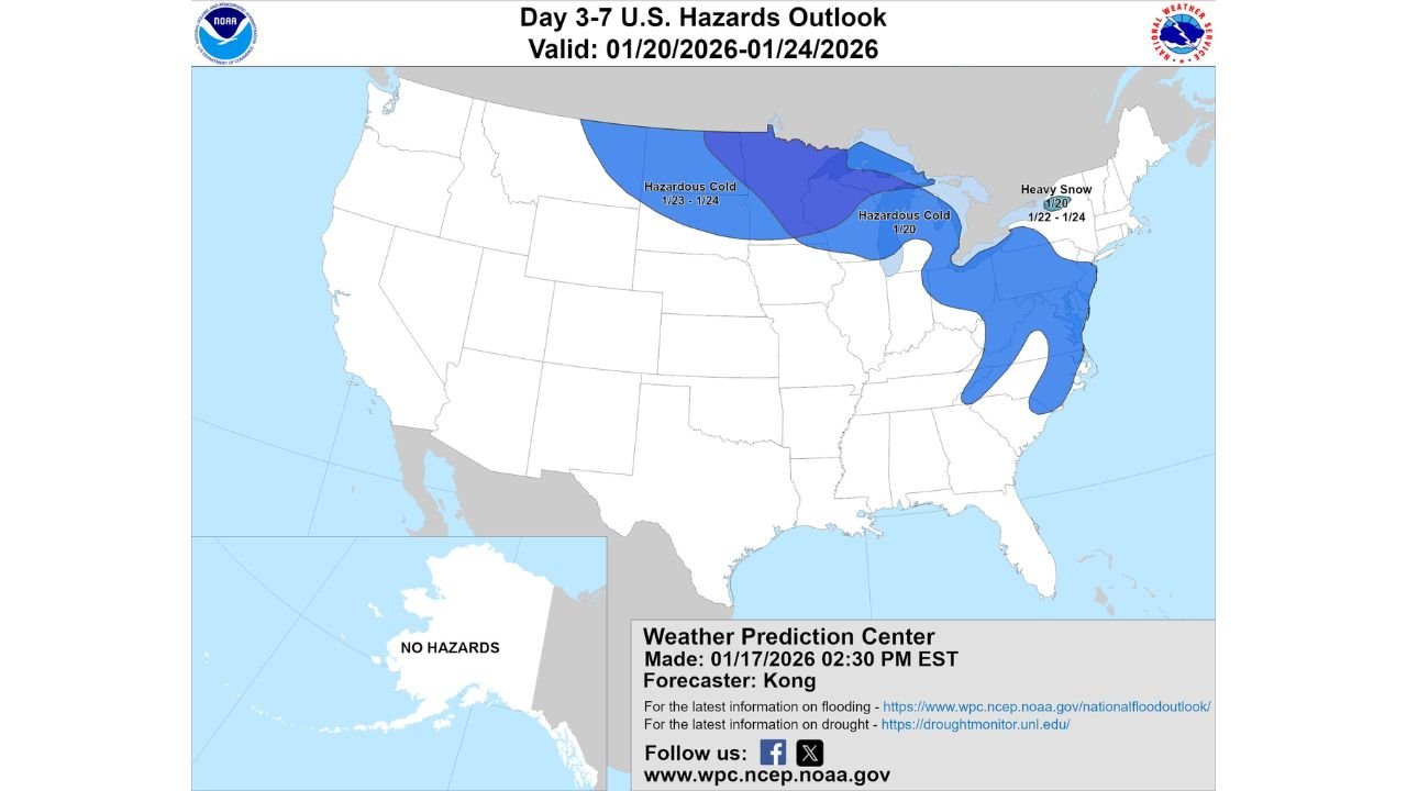
UNITED STATES — An updated Day 3–7 U.S. Hazards Outlook issued by the Weather Prediction Center shows a renewed threat of hazardous cold and heavy snow affecting multiple regions of the country between January 20 and January 24, 2026, with impacts focused across the Northern Plains, Upper Midwest, Great Lakes, and parts of the Northeast.
Forecast guidance highlights a broad zone of dangerously cold air developing first across the northern tier of the country before shifting east, while a separate area of heavy snow potential targets portions of the Great Lakes and interior Northeast.
Hazardous Cold Expands From the Northern Plains Into the Upper Midwest
The outlook places a large swath of hazardous cold across parts of Montana, North Dakota, Minnesota, Wisconsin, and Michigan, with the coldest conditions expected between January 20 and January 24.
Temperatures in these regions are forecast to run well below late-January averages, increasing the risk for frostbite, hypothermia, and strain on infrastructure. Overnight lows are expected to plunge into the single digits and below zero in several areas, particularly where snow cover reinforces the cold.
This cold air mass is tied to a strong northern flow pattern, allowing Arctic air to spill south and remain locked in place for several days.
Great Lakes and Northeast Face Elevated Heavy Snow Risk
In addition to the cold, the outlook highlights a distinct heavy snow threat across parts of the Great Lakes and interior Northeast, including areas of Michigan, upstate New York, Vermont, New Hampshire, and Maine.
The heavy snow signal is strongest around January 22–24, where a combination of cold air and favorable storm tracks could support significant accumulations, especially in lake-enhanced and higher-elevation regions.
While exact snowfall totals will be refined in shorter-range forecasts, the pattern supports disruptive travel conditions, including snow-covered roads, reduced visibility, and potential delays.
Timing Breakdown: When Impacts Are Most Likely
- January 20–21: Hazardous cold develops across the Upper Midwest and Great Lakes
- January 22–23: Cold intensifies and expands east; snow risk increases in the Great Lakes
- January 23–24: Heavy snow potential shifts into parts of the Northeast, while cold remains entrenched
This overlap of cold temperatures and snowfall raises concerns for icy roads, frozen pipes, and prolonged recovery time in affected communities.
Why This Pattern Is Concerning
The forecast setup favors persistence, meaning conditions may not improve quickly once established. Prolonged cold increases energy demand, while repeated snow events can compound travel and safety issues.
Even areas outside the heaviest snow zones may still experience dangerously low wind chills, making outdoor exposure hazardous during the peak of the cold.
What Happens Next
Forecast confidence is moderate to high for the overall pattern, but specific snowfall amounts and exact placement will become clearer as the event moves into the short-range window.
Residents across the Northern Plains, Upper Midwest, Great Lakes, and Northeast should closely monitor updates over the coming days and prepare for winter weather impacts that could extend for much of the week.