
Mississippi, Alabama, and Georgia Face Flash Flood Risk as Training Storms Target the Southeast
UNITED STATES — Parts of Mississippi, Alabama, and Georgia are facing an elevated flash flood threat as slow-moving thunderstorms continue to develop and repeatedly track across the same areas. Forecasters warn that this pattern could lead to dangerous rainfall accumulation, especially where storms “train” over already saturated ground.
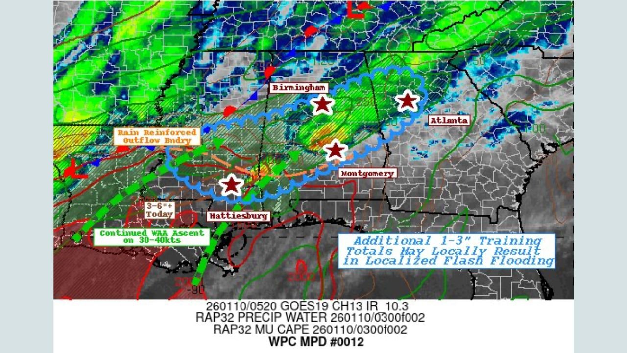
The Weather Prediction Center has issued a mesoscale discussion highlighting portions of southeast Mississippi, central Alabama, and northwest Georgia, where multiple rounds of heavy rain may fall in a short period of time.
Why Flash Flooding Is a Concern Across the Southeast
Current weather analysis shows a rain-reinforced outflow boundary stretching from Mississippi into Alabama, acting as a trigger for repeated thunderstorm development. Strong warm-air advection and abundant atmospheric moisture are feeding storms capable of producing very heavy rainfall rates.
Rainfall totals of 3 to 6 inches are possible in some locations, with additional 1 to 3 inches falling on top of already wet conditions. This combination significantly increases the risk of rapid runoff and flash flooding, even in areas that typically handle rainfall well.
Areas Most at Risk Right Now
The highest concern corridor extends from:
- Southeast Mississippi, including areas near Hattiesburg
- Central Alabama, including the Birmingham and Montgomery regions
- Northwest Georgia, including areas west and north of Atlanta
Urban locations, low-lying areas, and places with poor drainage are particularly vulnerable if storms repeatedly move over the same region.
What Residents Should Watch For
Flash flooding can develop quickly, especially during nighttime hours when visibility is limited. Residents across the affected states should remain alert for:
- Water covering roadways and underpasses
- Rapid rises in creeks and small rivers
- Flooded intersections and low-lying neighborhoods
- Emergency alerts or flash flood warnings
Drivers are urged not to attempt crossing flooded roads, as water depth and road damage may be difficult to judge.
Forecast Confidence and Next Updates
Forecast confidence is moderate to high that localized flash flooding will occur somewhere within the highlighted region, though the exact placement of the heaviest rain bands may still shift slightly. Meteorologists will continue refining the forecast as new radar trends and short-range model data become available.
Weather conditions like this can impact travel, outdoor events, and concert schedules across the region. For continued updates on weather patterns that may affect live music, touring, and event plans nationwide, stay connected with ChicagoMusicGuide.com.