
Mississippi and Alabama Under Moderate Excessive Rainfall Risk as Flash Flooding Threatens Through Saturday Morning
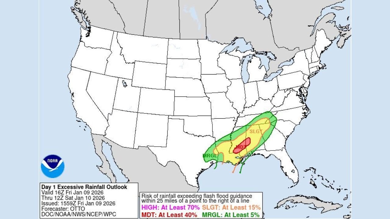
MISSISSIPPI — A moderate risk (Level 3 of 4) for excessive rainfall is in effect across portions of Mississippi and Alabama, as a powerful storm system is expected to bring repeated rounds of heavy thunderstorms through early Saturday morning. Forecast guidance indicates that training storms—storms moving over the same areas multiple times—could result in 5 to 8 inches of rainfall, significantly increasing the risk of dangerous flash flooding.
The excessive rainfall outlook highlights a focused corridor across central and southern parts of the two states, where saturated ground conditions and intense rainfall rates may overwhelm drainage systems and cause rapid rises on creeks, streams, and low-lying roadways.
Moderate Risk Zone Centers on Mississippi and Alabama
Weather Prediction Center outlooks place a Moderate Risk area over central Mississippi extending into western and central Alabama, surrounded by a broader Slight Risk zone across the lower Southeast. This level of risk signals a high confidence in scattered to numerous flash flooding incidents within the highlighted region.
Moderate Risk designations are relatively uncommon and are typically reserved for events where widespread flooding impacts are possible. Forecasters note that soil conditions, combined with the projected rainfall totals, could allow water to accumulate quickly—especially in urban areas and locations with poor drainage.
The risk extends beyond isolated downpours, as storms are expected to regenerate along the same axis for several hours, compounding rainfall totals overnight.
Rainfall Totals Could Reach 5 to 8 Inches
Quantitative precipitation forecasts show a pronounced band of heavy rain stretching from the north-central Gulf Coast through Mississippi and Alabama, with the heaviest amounts aligned near the Moderate Risk zone. In this corridor, rainfall rates may exceed one inch per hour, particularly within stronger thunderstorms.
The combination of slow-moving storms and persistent moisture transport from the Gulf of Mexico raises concern for rapid-onset flash flooding, even in areas that typically handle rainfall well. Rural roads, small creeks, and low-water crossings are especially vulnerable, while urban flooding may occur where storm drains become overwhelmed.
Forecasters stress that these totals could be reached in a relatively short timeframe, increasing the danger during overnight hours when visibility is reduced and flooding is harder to detect.
Training Thunderstorms Drive Flood Potential
A key factor in this event is the expected training effect, where thunderstorms repeatedly move over the same locations. This setup often develops when storms align parallel to upper-level winds, allowing new cells to continuously form upstream and track over previously affected areas.
In Mississippi and Alabama, this pattern could persist for several hours, turning localized heavy rain into a broader flooding concern. Even areas that initially escape heavy rain could be affected later as the storm band shifts or redevelops.
This type of setup has historically led to road closures, stranded vehicles, and swift-water rescues, especially when flooding develops faster than warnings can be acted upon.
Flooding Risks Extend Into Saturday Morning
The excessive rainfall threat is expected to continue through early Saturday, with conditions gradually improving later in the day as the storm system moves east. However, lingering high water levels may remain an issue even after rainfall tapers off.
Emergency officials urge residents to remain cautious, particularly overnight, and to avoid travel if heavy rain is ongoing. Flooded roads can be deceptive, and just a small amount of moving water can sweep vehicles off the roadway.
Residents are encouraged to stay updated with the latest local forecasts and warnings, especially as conditions may evolve rapidly depending on storm intensity and placement.
As Mississippi and Alabama face this heightened flooding threat, preparedness and awareness will be critical in reducing impacts. Heavy rain events of this magnitude can quickly turn hazardous, especially after dark. For continued updates on severe weather, regional impacts, and forecast developments affecting communities across the Southeast, visit ChicagoMusicGuide.com.