
Mississippi, Arkansas, Tennessee, and Northern Louisiana Face Severe Storm and Flash Flood Threat as Cold Front Moves In Friday
MISSISSIPPI — A strengthening cold front moving east on Friday is expected to trigger severe thunderstorms and a growing flash flooding threat across Mississippi, Arkansas, Tennessee, and northern Louisiana, placing much of the Lower Mississippi Valley and Mid-South in an active and potentially dangerous weather setup.
Forecast data shows the region entering a transition zone where warm, moisture-rich air from the Gulf collides with advancing colder air, creating an environment favorable for heavy rainfall, strong thunderstorms, and localized flooding.
Why This Setup Is Concerning
Meteorologists are closely watching this system because it combines multiple risk factors at the same time:
- A strong cold front pushing into warm, unstable air
- Deep Gulf moisture feeding storms ahead of the front
- Increasing wind energy aloft, which can help storms organize
- A slow enough storm progression to allow rainfall to pile up
This combination raises concern not only for strong storms, but also for excessive rainfall over short periods, which can overwhelm drainage systems and cause flash flooding.
Areas Most at Risk
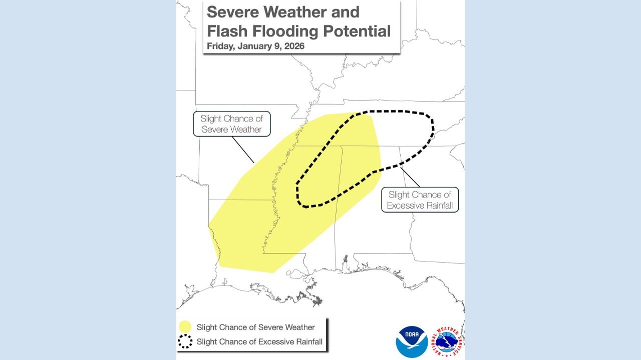
Current outlooks highlight a broad zone stretching from central and southern Arkansas through much of Mississippi and into western and middle Tennessee, with northern Louisiana also included in the risk area.
- Severe Storm Risk: Portions of Arkansas and Mississippi are most favored for strong thunderstorms capable of damaging wind gusts and isolated severe impacts.
- Flash Flood Risk: The greatest concern for excessive rainfall lies across Mississippi, western Tennessee, and nearby areas, where repeated storms could track over the same locations.
Even locations that avoid severe wind could still experience dangerous flooding, especially in low-lying or flood-prone areas.
Timing and What to Expect Friday
Storms are expected to develop and intensify on Friday, particularly from late morning through the evening hours, as the cold front advances eastward.
Residents may experience:
- Heavy downpours in a short time span
- Frequent lightning and gusty winds
- Periods of training storms, where rain repeatedly moves over the same area
- Rapid rises in creeks, streams, and urban roadways
Flooding can occur quickly and with little warning, even outside of typical river flood zones.
How This Fits Into the Bigger Pattern
This storm threat is part of a larger-scale weather pattern shift unfolding across the central and eastern United States. As colder air pushes south and east, it interacts with lingering warmth across the Gulf states, setting the stage for active and volatile weather.
While this system is expected to move through, similar setups can repeat when strong temperature contrasts exist — making this a pattern worth monitoring beyond just Friday.
Safety Reminders for Residents
With both severe storms and flash flooding possible, officials urge residents to stay weather-aware:
- Avoid driving through flooded roads — water depth is often deceptive
- Secure outdoor items that could become wind hazards
- Have multiple ways to receive weather alerts, especially overnight
- Be prepared to adjust travel plans if conditions deteriorate
Flooding remains one of the leading weather-related dangers, even during non-tornado events.
What Happens Next
As the cold front continues east, weather impacts will gradually shift toward the Southeast, while cooler and drier air works into parts of the central Mississippi Valley behind the system. Forecast confidence is high that storms will occur, though exact placement of the heaviest rain will become clearer closer to the event.
Residents across the affected states should stay alert as updated forecasts and advisories are issued.
If you live in or have plans across Mississippi, Arkansas, Tennessee, or northern Louisiana, keep checking local forecasts and stay prepared for rapidly changing conditions. For ongoing weather updates, regional impacts, and pattern breakdowns, continue following coverage from ChicagoMusicGuide.com.