
Missouri and Illinois Face Two Rounds of Light Snow as NWS St. Louis Warns of Slick Travel Into Friday Night
ST. LOUIS, MISSOURI — A pair of light snow rounds are expected to move across parts of Missouri and Illinois, beginning Thursday evening and continuing through Friday evening, according to updated guidance from National Weather Service St. Louis. While snowfall amounts are expected to remain modest, forecasters warn that slick spots could develop during overnight and early morning hours, particularly on elevated surfaces.
The setup favors short-duration snowfall events rather than a prolonged winter storm, but timing and temperatures could still create localized travel issues, especially near and east of the Mississippi River.
First Round of Light Snow Arrives Thursday Evening
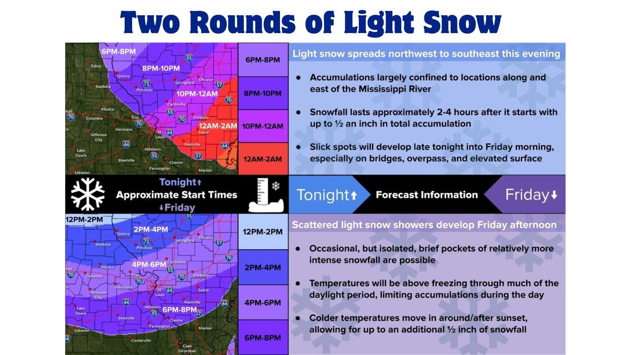
The first wave of light snow is forecast to spread from northwest to southeast across the region Thursday evening, with onset times varying by location. Snow is expected to develop between 6 p.m. and 10 p.m., reaching the St. Louis metro area later in the evening before tapering off overnight.
Forecasters indicate that snowfall with this round will generally last two to four hours, producing up to one-half inch of accumulation in favored areas. Most of the measurable snow is expected along and east of the Mississippi River, while areas farther west may see lighter totals or only brief flurries.
Even with limited accumulation, bridges, overpasses, and elevated roadways could become slick late Thursday night into early Friday as surface temperatures cool.
Friday Afternoon Brings a Second Snow Chance
A second round of scattered light snow showers is expected to develop Friday afternoon and persist into Friday evening. This round may be more intermittent, with snowfall occurring in bursts rather than a steady band.
Daytime temperatures on Friday are expected to remain above freezing for much of the afternoon, which should limit accumulations initially. However, colder air moving in around and after sunset could allow snow to stick more efficiently, adding another dusting to up to one-half inch in isolated spots.
Meteorologists note that brief pockets of slightly heavier snowfall are possible, though widespread impacts are not anticipated.
Slick Spots Possible Friday Night and Saturday Morning
Although overall snowfall totals will remain light, the timing of colder temperatures raises concerns for slick travel conditions late Friday night into Saturday morning. Residual moisture from earlier snowfall could freeze, particularly in shaded or elevated areas.
Drivers are urged to remain cautious during overnight and early morning travel, especially across eastern Missouri and southwestern and central Illinois, where accumulations are most likely.
Why This Is Not a Major Winter Storm
This system lacks the prolonged cold air and deep moisture needed to produce heavy snow. Instead, it features short-lived snow bursts, marginal temperatures, and limited accumulation potential. As a result, impacts are expected to be localized and brief, rather than widespread.
Still, even light snow can create hazards when combined with nighttime cooling — a key factor forecasters continue to monitor closely.
As Missouri and Illinois move through another midwinter system, residents are encouraged to stay aware of changing conditions and updated advisories. While this event is expected to remain minor, timing and temperatures could still create pockets of hazardous travel. For continued weather updates, regional forecasts, and coverage of how conditions may affect events and daily plans, visit ChicagoMusicGuide.com.