
Missouri and Illinois See Brief Snow Showers and Strong Winds Tonight as Cold Front Moves Through the St. Louis Region
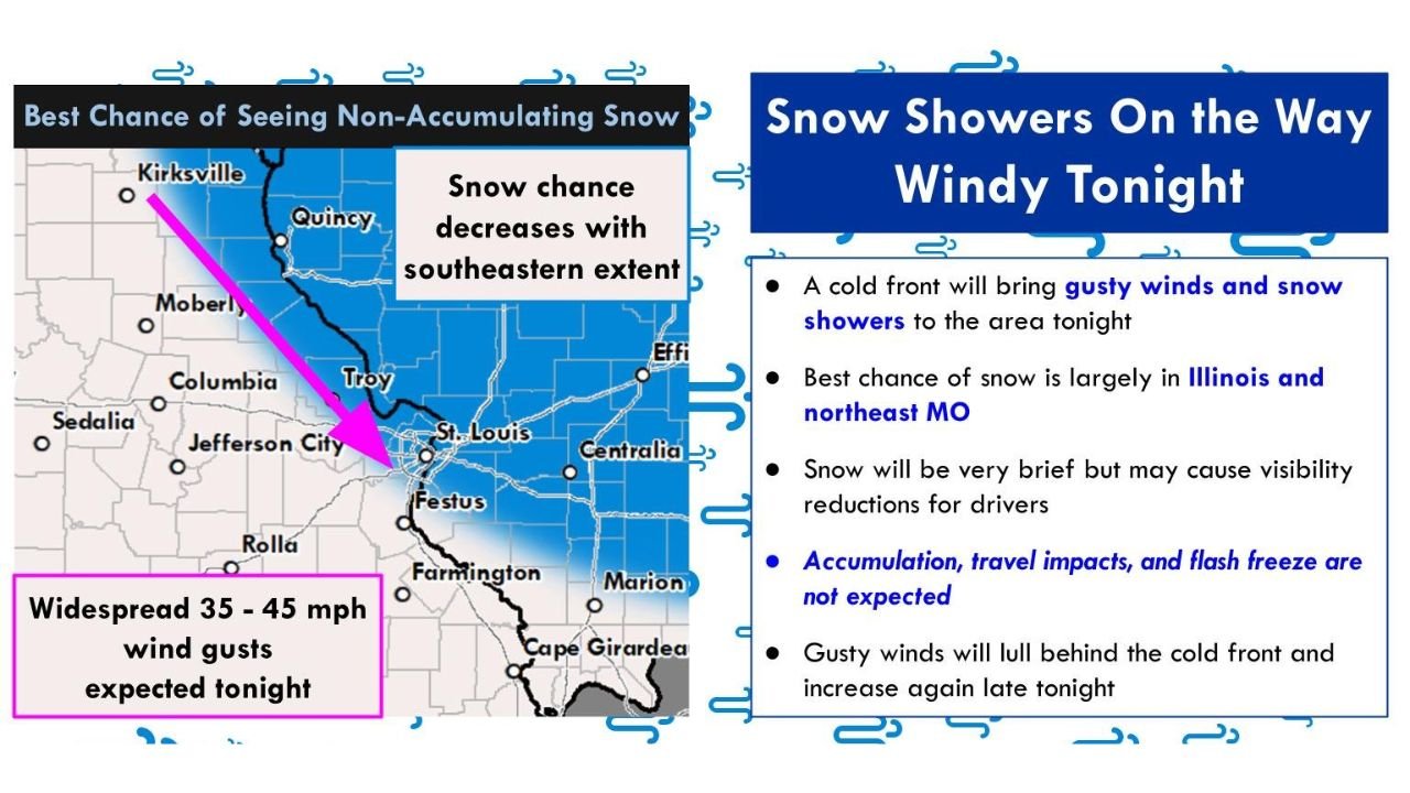
MISSOURI — A fast-moving cold front is sweeping through the St. Louis forecast area tonight, bringing brief snow showers, gusty winds up to 45 mph, and short-term visibility reductions, according to the National Weather Service in St. Louis. Forecasters stress that snow accumulation and significant travel impacts are not expected, despite the wintry appearance.
The system will primarily affect eastern Missouri and western to central Illinois, including the St. Louis metro area, as it pushes southeast overnight into early Sunday.
St. Louis Forecast Area Is the Primary Impact Zone
NWS St. Louis graphics show the best chance for seeing non-accumulating snow showers across:
- The St. Louis metropolitan area
- Eastern Missouri counties north and south of I-70
- Western and central Illinois counties near and east of the Mississippi River
Snow chances decrease quickly farther southeast, meaning communities outside the NWS St. Louis coverage area are less likely to see wintry precipitation.
Why Snow Will Be Brief and Non-Accumulating
While snow showers are expected, meteorologists emphasize that:
- Snow will be short-lived and scattered
- Surface temperatures remain too warm for accumulation
- Any snowfall will melt quickly after it falls
Because of this, accumulation, hazardous travel, and flash freeze conditions are not anticipated, even during the strongest bursts.
Wind Is the Main Hazard Tonight
The most noticeable impact from this system will be strong winds, not snow.
- Wind gusts: 35 to 45 mph
- Gusts increase as the cold front passes
- Winds may briefly diminish, then strengthen again late tonight into early Sunday
These winds could lead to:
- Brief visibility reductions during snow showers
- Difficult driving conditions for high-profile vehicles
- Isolated minor power issues in exposed areas
Timing for the St. Louis Region
- This evening: Cold front enters eastern Missouri
- Late tonight: Snow showers cross the St. Louis metro and western Illinois
- Early Sunday morning: Snow ends, gusty winds persist before gradually easing
By Sunday morning, skies will trend drier, but colder air will settle in behind the front.
Bottom Line
- Snow showers: Possible but brief
- Accumulation: Not expected
- Wind gusts: Up to 45 mph
- Travel impacts: Minor and short-lived
While this system may look wintry at times, it does not meet winter storm criteria for the St. Louis region.
For continued weather updates and local impact coverage, stay with ChicagoMusicGuide.com, and share what conditions you’re seeing tonight in your area.