
Missouri and Western Illinois See Rare Early-March Instability Surge as HRRR Signals 3,000–3,600+ CAPE Ahead of Tuesday Severe Threat
ILLINOIS — The latest 00z HRRR model run is turning heads, showing levels of atmospheric instability that look far more like May or June than early March.
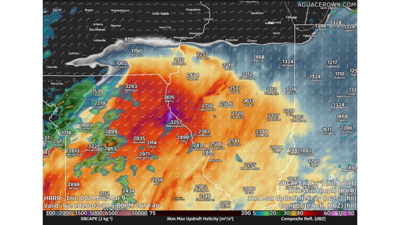
Forecast data valid Tuesday evening highlights a corridor of extreme surface-based instability (SBCAPE) stretching from central and eastern Missouri into western and central Illinois — including Quincy, Bowling Green, Jacksonville, Springfield, Peoria, and Bloomington.
For early March, these numbers are unusually high.
CAPE Values Rival Late Spring
Model projections indicate:
- 3,000–3,600+ J/kg SBCAPE across parts of northeast Missouri and west-central Illinois
- Widespread 2,500–3,000 J/kg from Columbia and Jefferson City east through Springfield, Jacksonville, and into central Illinois
- Still impressive 2,000+ J/kg extending toward Champaign and areas west of Indianapolis
These instability values are more commonly seen during peak severe weather season in late spring.
The highest modeled values appear near:
- Quincy, IL
- Bowling Green, MO
- Kirksville, MO
- Jacksonville, IL
Warm, Moist and Primed
The environment supporting this setup includes:
- Surface temperatures climbing into the upper 70s to low 80s
- Dew points rising into the upper 60s
- Steep mid-level lapse rates
That combination fuels buoyancy — allowing air parcels to rise rapidly and potentially produce intense updrafts.
Model soundings from the region show strong instability profiles with relatively low cloud bases and favorable wind shear parameters.
Supercell Signals in the Data
Forecast sounding analysis suggests:
- Sufficient low-level shear to support rotating storms
- Critical angle values supportive of tornado potential
- Parameter space consistent with organized supercells
Composite reflectivity and updraft helicity tracks in the HRRR simulation hint at discrete storm structures capable of producing severe weather across portions of Missouri and western Illinois Tuesday evening.
However, it is important to remember this is model guidance and not a guaranteed outcome. Exact storm placement, timing, and mode will depend on mesoscale details that become clearer closer to the event.
Why This Stands Out for Early March
Early March typically features:
- Limited instability
- Cooler surface temperatures
- Marginal moisture return
This setup breaks that mold.
With late-spring thermodynamics appearing in early March, the atmosphere could support stronger storms than normally expected for this time of year.
If the upper-level system provides adequate lift and storm coverage remains discrete long enough, the ingredients would be present for significant severe weather.
Areas to Watch
The most concerning corridor currently appears to run from:
- Central and northeast Missouri
- West-central Illinois
- Into portions of central Illinois
Communities including Quincy, Springfield, Peoria, Bloomington, Jacksonville, and surrounding areas should closely monitor forecast updates.
Bottom Line
The latest high-resolution guidance shows unusually high instability values for early March across Missouri and Illinois — levels more typical of late spring. With warm temperatures, rich moisture, and strong lapse rates in place, the environment could support supercells capable of severe weather Tuesday evening.
Forecast details will continue to evolve, but this is a setup that clearly warrants attention.
Chicagomusicguide.com will continue tracking updates as new model data refines the severe weather threat.