
Missouri, Arkansas, Oklahoma, and Southern Illinois Face Brief but Dangerous Wind and Tornado Threat as Strong Line Pushes East Friday Morning
MISSOURI — A fast-moving but potentially dangerous severe weather setup is unfolding across parts of the Lower Missouri Valley and Mid-South early Friday, as a powerful line of storms moves east with damaging winds and a brief tornado threat. While the overall event is short-lived, forecasters warn that the next 1–2 hours could bring significant impacts in localized areas.
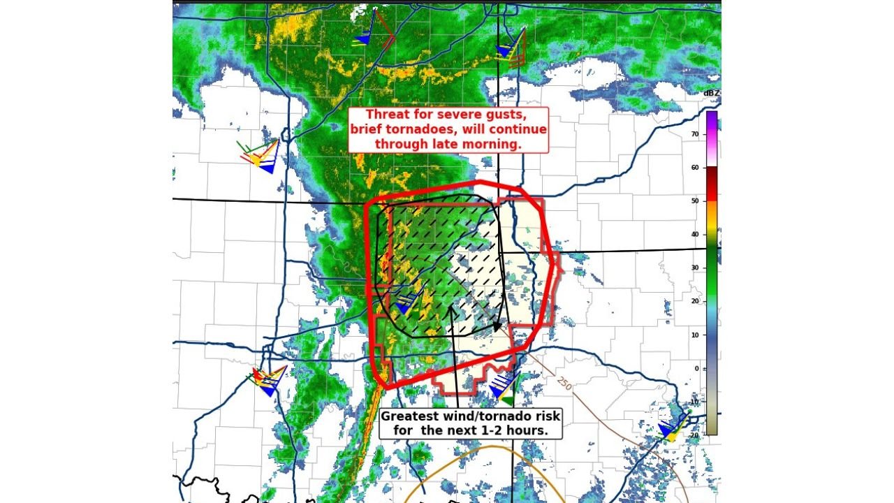
SPC Mesoscale Discussion Confirms Ongoing Tornado and Wind Risk
According to the latest Mesoscale Discussion #8 from the Storm Prediction Center, the greatest risk window is occurring Friday morning, focused mainly across:
- Central and Eastern Missouri
- Northern Arkansas
- Eastern Oklahoma
- Far Southern Illinois
Forecasters highlight a narrow but intense corridor where severe wind gusts and brief tornadoes remain possible as storms surge eastward.
Wind Gusts Could Reach 75–90 MPH in Isolated Spots
Radar and model-based analysis shows a well-organized line of storms tapping into an unusually strong low-level jet, allowing higher-altitude winds to mix down toward the surface.
Most probable impacts include:
- Damaging straight-line winds (75–90 mph possible)
- Brief, fast-spin-up tornadoes
- Scattered power outages
- Downed trees and power lines
While widespread long-track tornadoes are not expected, the environment favors short-lived, embedded tornadoes, especially along the leading edge of the line.
Why This Setup Is Dangerous — But Short-Lived
Meteorologists note this is a unique and somewhat deceptive setup.
- Wind shear is very strong
- Instability is limited
- Storms are moving quickly
This means storms may struggle to maintain structure for long periods, but any storm that does intensify briefly could produce severe impacts very quickly. The strongest winds are expected immediately behind the cold front, where momentum transfer is maximized.
Importantly, this is not a day-long severe weather outbreak. The window for the highest risk is narrow, generally lasting one to two hours in any given location.
Cities Most Likely to See Strong Impacts
Based on radar trends and storm motion, areas most at risk this morning include:
- St. Louis, MO
- Springfield, MO
- Little Rock, AR
- Jonesboro, AR
- Southeast Missouri Bootheel
- Southern Illinois near the Mississippi River
Storms will continue shifting east, gradually weakening as they encounter less favorable conditions.
Bottom Line: Stay Alert Despite the “Brief” Nature of the Threat
Even though this is not a prolonged severe weather event, the intensity during its short duration should not be underestimated. A brief surge of damaging winds or a quick tornado can cause significant damage in minutes.
Residents are urged to:
- Monitor local warnings closely
- Secure loose outdoor items
- Be prepared for brief power outages
- Have multiple ways to receive weather alerts
The system will continue to move east and weaken later this morning, bringing an end to the severe threat.
Stay weather-aware and follow ongoing updates at ChicagoMusicGuide.com as conditions evolve across the Midwest and Mid-South.