
Missouri, Illinois, Indiana and Ohio Placed in Day 4 Slight Risk March 26 as Organized Severe Storm Setup Signals Damaging Winds, Large Hail and Tornado Potential
CHICAGO, ILLINOIS — A more concerning severe weather signal is now emerging for Thursday, March 26, 2026, as a Day 4 Slight Risk has been introduced from Missouri through Illinois, Indiana and into Ohio.
The updated outlook expands the previous risk area and reflects increasing confidence that the environment may support organized severe thunderstorms across the central Midwest.
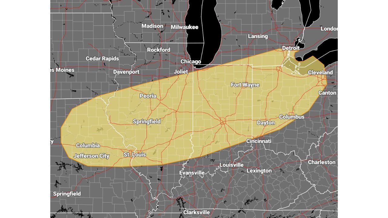
Slight Risk Corridor Stretches From St. Louis to Cleveland
The outlined risk area includes major population centers such as:
- Columbia, Jefferson City and St. Louis, Missouri
- Springfield, Peoria and central Illinois communities
- Fort Wayne, Indiana
- Dayton, Columbus and Cincinnati, Ohio
- Extending toward Cleveland and areas near Detroit
This corridor runs southwest to northeast, following a projected storm track along a sagging cold front expected to move across the region Thursday.
Environment Trending Toward Organized Severe Storms
Forecast analysis indicates that the atmospheric setup is becoming more favorable for organized convection. While it remains several days out, current guidance shows:
- Strengthening wind shear profiles
- Adequate instability for sustained updrafts
- A frontal boundary serving as a focus for storm development
If storms initiate, they are likely to organize rather than remain isolated and weak.
Damaging Winds, Large Hail and Tornado Risk All Possible
With a Slight Risk designation in place, all severe hazards are considered possible within the outlined region.
That includes:
- Damaging straight-line winds
- Large hail
- A tornado threat
The combination of shear and frontal forcing raises the potential for discrete supercells initially, possibly evolving into more organized storm clusters or lines as the system progresses eastward.
Chicago Near the Northern Edge
The Chicago metro area appears near the northern gradient of the risk zone. While the highest confidence for severe development currently lies across central Illinois, Indiana and into Ohio, shifts in the frontal position could alter the northern extent in later updates.
Residents across Illinois, Indiana, Missouri and Ohio should continue monitoring forecast updates as Thursday approaches. It is still early in the forecast cycle, but trends are pointing toward a setup capable of producing impactful severe weather.
ChicagoMusicGuide.com will continue tracking developments and provide updated details as the March 26 system draws closer.