
Missouri Storm Development Zone Expands Across Northern Missouri as St Louis Wind Profiles Signal Increasing Tornado Risk Into Evening Hours
MISSOURI — A developing weather setup across northern Missouri is drawing increasing attention as storm development attempts to organize within a favorable environment, raising concerns for a potential tornado threat into the evening hours. Areas across central and northern Missouri, including regions north of St. Louis, are being closely monitored as atmospheric conditions continue to evolve.
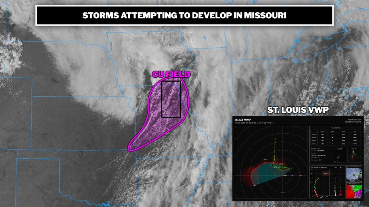
Storms Attempting to Develop Across Northern Missouri
Satellite and atmospheric analysis show a defined zone of cumulus cloud development (CU field) expanding across northern Missouri, indicating that storms are trying to initiate in this region.
This area, stretching across portions of north-central Missouri, represents a key zone where storms could begin to organize if conditions remain supportive. While not all developing clouds will become storms, the presence of a strong CU field suggests that the atmosphere is primed for thunderstorm development.
The concern is that if storms can form and remain somewhat discrete rather than merging too quickly, they will have a greater chance to become organized and potentially severe.
Favorable Environment Supports Tornado Potential
The broader environment across Missouri is described as highly supportive for severe weather, particularly if storms are able to establish themselves. Key ingredients such as instability and moisture are already in place, but the most critical factor is the presence of increasing low-level wind shear.
Wind profile data near St. Louis shows strengthening shear with height, a key component needed for storm rotation. As the evening progresses, this shear is expected to increase further, improving the chances for rotating thunderstorms.
If storms develop within this environment, they could quickly become supercells capable of producing tornadoes, especially across northern Missouri and areas approaching eastern Missouri near St. Louis.
Storm Mode Will Determine Severity of the Threat
One of the most important factors in this setup is how storms evolve. If storms remain isolated and discrete, they are more likely to tap into the favorable wind shear environment, increasing the risk for tornado development.
However, if storms grow upscale too quickly into a larger cluster or line, the tornado risk may decrease slightly, shifting the threat more toward damaging winds and heavy rainfall.
This uncertainty means that real-time storm behavior will be critical in determining the overall impact across Missouri.
Evening Hours Will Be Critical for Storm Intensification
The timeframe of greatest concern is expected to be during the evening hours, when low-level winds strengthen further and provide additional support for storm organization.
Areas across northern and eastern Missouri, including regions closer to St. Louis, may see rapid changes in storm intensity if storms successfully develop.
Residents in these areas should remain alert as conditions can quickly shift from quiet to active, especially during peak evening hours when atmospheric dynamics are strongest.
What Residents Across Missouri Should Watch For
People across Missouri, particularly in northern parts of the state, should closely monitor weather conditions as storms attempt to develop.
Key things to watch include rapid cloud growth, increasing storm coverage, and any signs of strengthening thunderstorms. If storms organize, they could produce tornadoes, strong winds, and localized severe impacts.
Having access to real-time alerts and weather updates will be important, especially as the situation evolves into the evening.
As storm development continues to be monitored across Missouri and the St. Louis region, staying informed is essential. For ongoing updates, storm tracking, and regional coverage, visit ChicagoMusicGuide.com.