
Moderate Risk Removed Across Virginia, Maryland, North Carolina, South Carolina, and Pennsylvania as Damaging Wind Threat Continues Along East Coast
WASHINGTON, DISTRICT OF COLUMBIA — The latest severe weather outlook update has removed the Level 4 Moderate Risk zone across the Mid-Atlantic, significantly lowering the highest threat level that had previously covered parts of Virginia, Maryland, North Carolina, Pennsylvania, and Washington D.C.
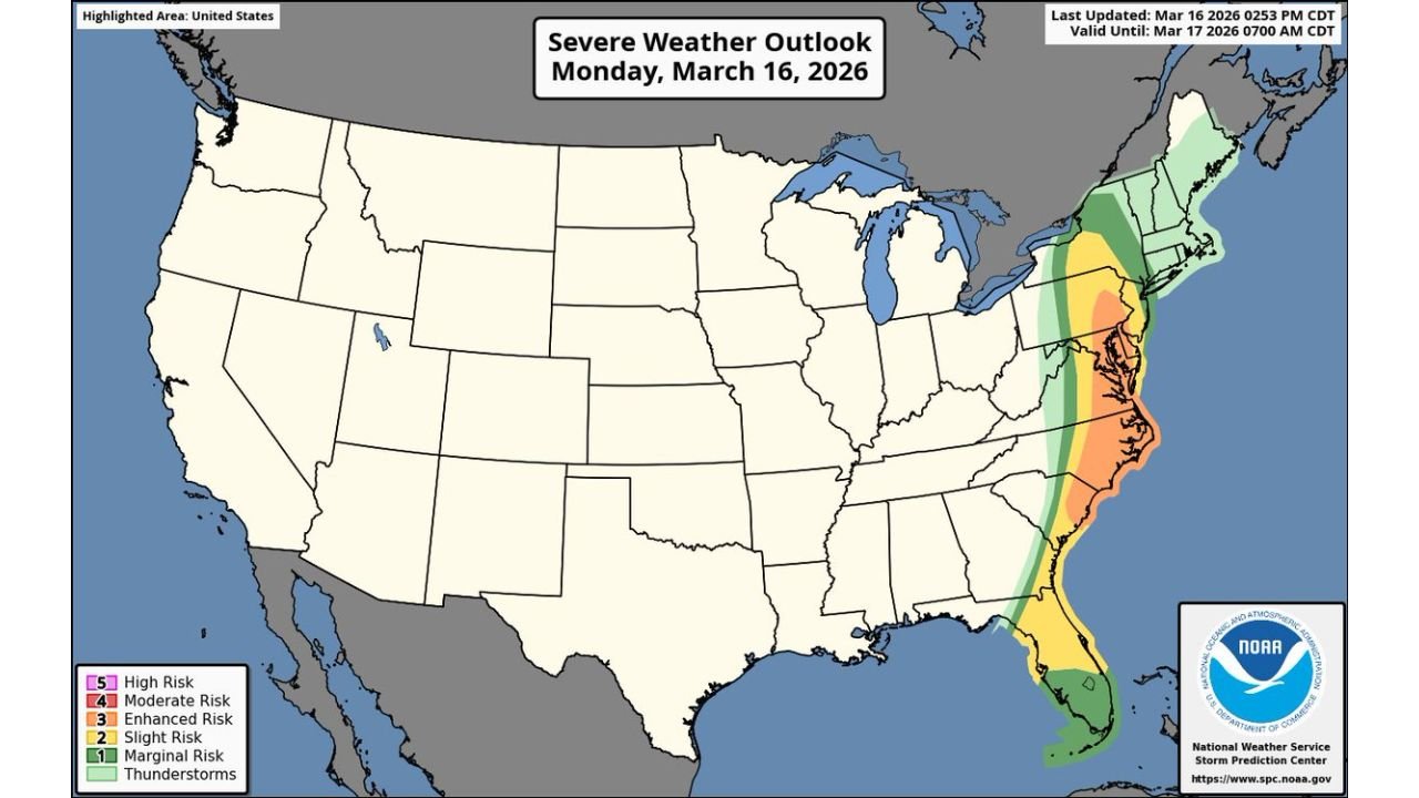
Despite the downgrade, a broad corridor of severe weather risk remains in place along the East Coast, stretching from Florida through Georgia, South Carolina, North Carolina, Virginia, Maryland, Delaware, New Jersey, and into Pennsylvania and New York.
Storm activity is expected to move through the region during the afternoon and evening hours before eventually shifting offshore overnight.
Severe Weather Zone Stretches From Florida to Pennsylvania
Updated outlook maps show a long band of storm risk positioned along the Atlantic coastal states.
The most active weather corridor extends through:
- Florida
- Georgia
- South Carolina
- North Carolina
- Virginia
- Maryland
- Delaware
- New Jersey
- Pennsylvania
Within this corridor, the highest remaining storm risk is now categorized as Enhanced Risk, particularly across parts of eastern North Carolina, Virginia, and Maryland.
A surrounding Slight Risk zone expands farther north and south, covering additional portions of the Southeast and Mid-Atlantic regions.
Damaging Winds Remain the Primary Threat Along the Coast
Updated wind outlook maps show a concentrated corridor where strong wind gusts remain possible as storms move north along the Atlantic coastline.
The highest wind probabilities appear across areas including:
- North Carolina
- Virginia
- Maryland
- Delaware
- New Jersey
Within this zone, storms could produce damaging straight-line winds capable of downing trees and causing scattered power outages.
Wind probabilities are strongest within a corridor centered over the Chesapeake Bay region and surrounding Mid-Atlantic communities.
Communities from Raleigh and Norfolk to Washington D.C., Baltimore, and Philadelphia remain within the region where the strongest winds could develop.
Limited Tornado Potential Still Exists Across the Southeast and Mid-Atlantic
While the overall tornado threat has been lowered compared to earlier outlooks, the updated maps still show isolated tornado potential across parts of the Southeast and Mid-Atlantic.
Areas where brief tornadoes remain possible include:
- Eastern North Carolina
- Southeastern Virginia
- Coastal South Carolina
- Parts of Georgia
- Northern Florida
The tornado outlook indicates a narrow band of potential tornado development tracking along the Atlantic coastal plain as storms move north through the region.
However, the risk is now considered much more isolated compared with earlier expectations.
Storm Activity Expected to Move Offshore Late Tonight
The storm system is expected to continue tracking northeast along the East Coast during the evening hours.
As the storms progress through Virginia, Maryland, Delaware, and New Jersey, the activity should gradually shift offshore into the Atlantic Ocean later tonight.
Once the storm line moves offshore, conditions across much of the Mid-Atlantic and Southeast are expected to begin calming overnight.
Even with the removal of the Moderate Risk designation, the storm corridor still carries the potential for brief but intense thunderstorms capable of producing strong wind gusts across several East Coast states.
Residents across the region should remain alert for rapidly changing weather conditions during the evening hours.
For continuing updates on severe weather developments and national storm coverage, readers can follow the latest reports and forecasts at ChicagoMusicGuide.com.