
Multiple Storm Systems Are Lining Up to Target Kansas, Missouri, Iowa and Illinois in Early April With Repeated Chances for Damaging Winds, Large Hail and Tornadoes Across the Central United States
KANSAS CITY, MO — Spring is not asking for permission this year. Across Kansas, Missouri, Iowa and Illinois, the atmosphere is already assembling the ingredients for what could be one of the most active severe weather stretches the central United States has seen to open an April in recent memory. Multiple storm systems. Back-to-back chances. And a region that knows better than anywhere else in the country exactly what that combination can produce.
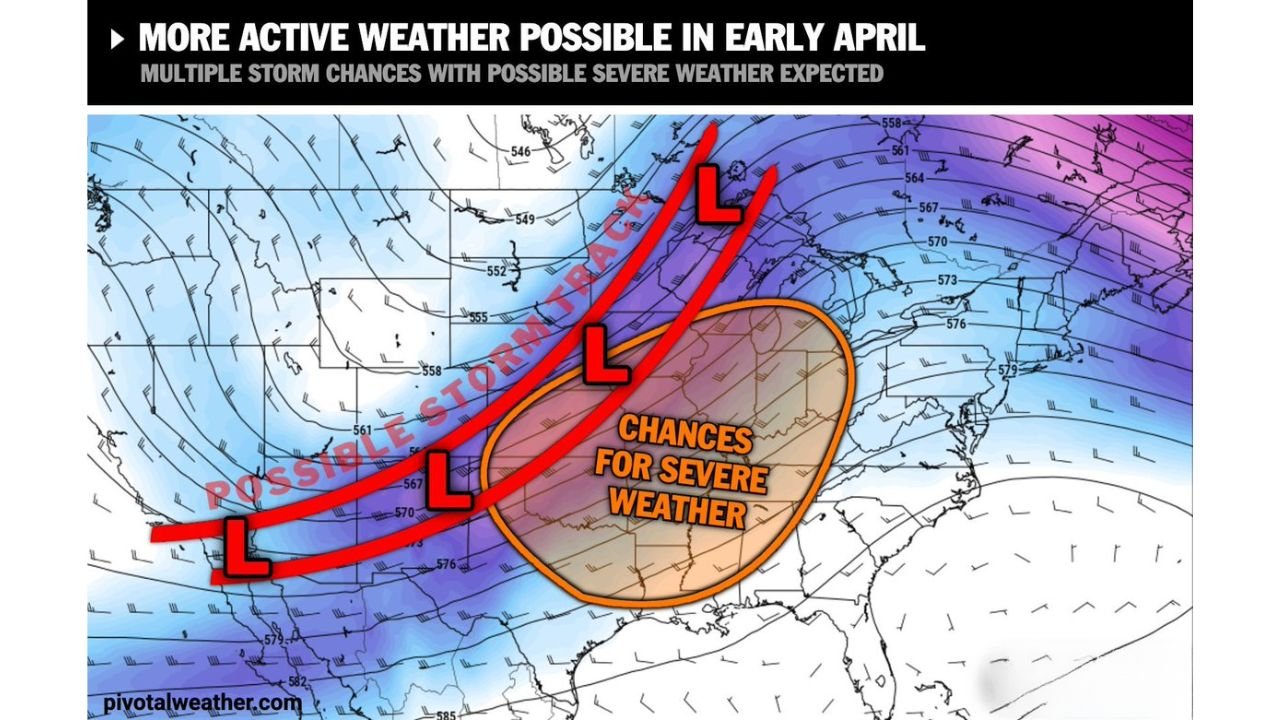
Why Early April 2026 Is Different From a Normal Spring Week
This is not a standard unsettled weather pattern where a few storms roll through and move on. Current storm track analysis is showing a series of low pressure systems lined up in sequence, each one tracking through roughly the same corridor from the southern Plains northeastward through the Midwest and into the Great Lakes. The first system moves through. The atmosphere barely recovers. The second system arrives. Then a third.
That kind of repeated forcing through the same geographic zone is what separates an inconvenient rainy week from a week that produces damage reports, emergency declarations and communities without power. The Plains and Midwest are staring down exactly that kind of setup as April begins.
The Corridor That Is Most at Risk and Why
The storm track data is pointing a clear arrow through a specific zone — Kansas, Missouri, Iowa, Illinois and Indiana, with Nebraska and Oklahoma on the southern and western flanks. This is not a coincidence of geography. This corridor sits directly in the overlap zone between three critical atmospheric ingredients that come together every spring.
Warm, moist air surges northward from the Gulf of Mexico. Cold, dry air drops southward from Canada. The jet stream cuts through the middle with enough wind shear to organize the storms that form along that clash zone into something far more dangerous than ordinary thunderstorms. When all three line up, the results can be severe. Right now, the pattern is aligning them repeatedly over the same states in the same week.
What You Need to Know About Each Threat
Damaging straight-line winds are the most democratic threat in this pattern — meaning they do not stay neatly inside a tornado path. Squall lines racing ahead of cold fronts can produce wind gusts of 60 mph or higher across hundreds of miles in a matter of hours. Fences down. Trees across roads. Power out for days. This threat will impact the widest number of people across the risk zone.
Large hail is the threat that catches people off guard most often. A supercell thunderstorm can produce baseball-sized hail with very little advance notice at the local level even when the broader forecast has flagged the risk for days. Anyone with a vehicle parked outside, crops in the field or a roof that has already seen better days needs to take this threat seriously across Kansas, Oklahoma and Missouri specifically.
Tornadoes are the threat that defines this corridor on the national stage. Whether this pattern produces a significant tornado outbreak or isolated spin-ups will depend on exactly how the moisture, shear and individual storm timing comes together with each system. That answer is not fully available yet. What is available is the knowledge that the setup is capable of supporting tornado-producing supercells, and that is enough to treat it with full respect.
Where Each State Stands Heading Into This Pattern
🔴 Kansas — The state sitting most squarely in the crosshairs of this entire pattern. Multiple system passages directly overhead. All three threats in play every time a system moves through. If you are in Wichita, Salina, Dodge City or anywhere in between, this week demands your full attention.
🔴 Missouri — Kansas City through Columbia and into St. Louis sits directly inside the repeated storm passage corridor. Damaging winds and large hail are the highest-confidence threats. Tornado potential with each organized supercell that fires along the front.
🔴 Iowa — Des Moines, Cedar Rapids and the surrounding communities are in the active zone as each system lifts northeast. The tornado and large hail threat is real and will require close monitoring with each individual storm system.
🟠 Illinois — Chicago metro through Springfield and into southern Illinois falls on the eastern edge of the primary severe weather zone. Damaging wind events from fast-moving squall lines are the primary concern. Hail and isolated tornado potential secondary but not dismissible.
🟠 Nebraska — Omaha through Lincoln and into the Platte River Valley sits on the northern flank of the hail and wind threat. Large hail is the headline risk for Nebraska with this pattern given the early April timing.
🟠 Oklahoma — Northern Oklahoma from Enid through Ponca City sits in the southern extension of the risk zone. Tornado-capable supercells are a real possibility here, particularly with systems that track along the Kansas-Oklahoma border.
🟠 Indiana and Michigan — As each system exits the primary zone and tracks northeast, the severe weather threat extends into the Great Lakes corridor. Damaging winds are the primary concern as squall lines accelerate through the region.
🟢 Colorado and the Rockies — West of the storm development zone. Minimal organized severe weather threat from this particular pattern.
How Confident Is This Forecast Right Now
| Threat | Affected States | Confidence Level | Key Uncertainty |
|---|---|---|---|
| Damaging Winds 60+ mph | KS, MO, IA, IL, IN | 🔴 Moderate-High | Exact squall line timing |
| Large Hail Baseball-Sized | KS, OK, NE, MO | 🔴 Moderate-High | Supercell organization |
| Tornadoes | KS, MO, IA, OK | 🟠 Moderate | Moisture depth and shear |
| Multi-Day Active Pattern | Full corridor | 🟠 Moderate-High | Individual system details |
| Exact Timing Per System | All states | 🟡 Low-Moderate | Sharpens daily this week |
What to Do Before the First System Arrives
The window between now and Monday night is the preparation window. Here is what matters most right now for anyone in the risk zone.
Make sure your wireless emergency alerts are turned on on every phone in your household — these are the alerts that sound even when your phone is silenced and they are the fastest warning delivery system available. Know the difference between a Severe Thunderstorm Watch (conditions are favorable, stay alert) and a Severe Thunderstorm Warning (a severe storm is happening now, take action immediately). The same logic applies to tornado watches and warnings.
If you have a safe room, basement or interior room on the lowest floor of your home, know exactly how to get there in the dark. Storms that produce tornadoes do not always arrive during daylight hours.
This pattern will be updated daily as each system comes into sharper model resolution. Check back for updates as the week progresses.
Data Sources: NOAA/NWS Storm Prediction Center | Atmospheric Model Analysis March 28, 2026 | Pattern valid early April 2026
The Plains and Midwest Are Entering One of the Most Watched Weather Windows of the Spring Season
Severe weather does not announce itself with enough warning to start preparing after the watch is issued. Stay informed at ChicagoMusicGuide.com — your source for daily severe weather updates, storm system tracking and tornado coverage across Kansas, Missouri, Iowa, Illinois and the entire United States.