
New England, New York and Mid-Atlantic Face Uncertain Weekend Snow Setup as Confidence Remains Low Outside the Carolinas
UNITED STATES — Early outlooks for Sunday’s potential winter weather system continue to show low confidence for meaningful snow across much of New England, New York, and the Mid-Atlantic, according to analysis from Boston Weather Consulting. While a developing coastal system may bring significant snow to areas well offshore, inland impacts remain uncertain and appear limited at this time.
Forecasters stress that the setup is highly subject to change, particularly as small shifts in storm track could dramatically alter snowfall outcomes along the East Coast.
Light Snow Possible Inland, Heavier Impacts Likely Offshore
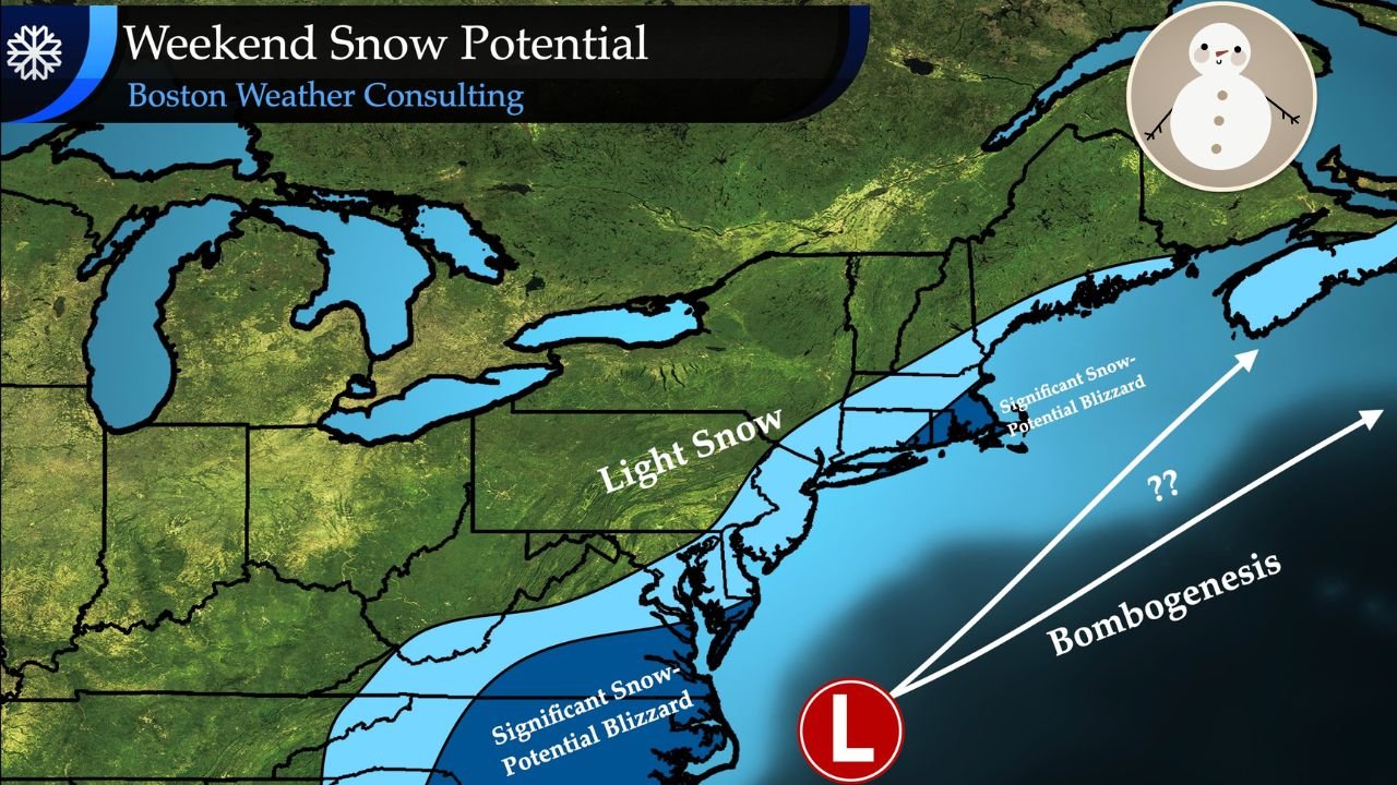
Current guidance suggests that most inland areas from Pennsylvania through New York and interior New England would see light snow at best, should the system develop as currently projected. The graphic highlights a broad inland zone labeled “Light Snow,” indicating limited accumulation potential for cities away from the immediate coast.
In contrast, the highest snow potential remains offshore, where stronger dynamics could support significant snow and blizzard conditions over the western Atlantic. These heavier impacts would largely miss inland population centers unless the storm track shifts farther west.
Coastal Track and Bombogenesis Remain the Key Wildcards
The forecast uncertainty is driven by the possibility of rapid storm intensification, or bombogenesis, occurring offshore. If the low-pressure system strengthens quickly and tracks closer to the coastline, snow bands could push farther inland.
At this stage, however, confidence outside of the Carolinas remains low, and the most intense impacts are expected to stay over the ocean. Forecasters note that even small deviations in track could change snowfall outcomes significantly, particularly for coastal communities.
Why Confidence Is Still Low for Sunday
Meteorologists emphasize that this system is still several days out, and model solutions continue to vary. Differences in timing, storm strength, and distance from the coast all contribute to the uncertainty.
Because of these variables, snowfall projections for New England, New York, and the Mid-Atlantic remain preliminary, and forecasters caution against locking in expectations too early.
What Residents Should Watch For Over the Next Few Days
Residents across the Northeast and Mid-Atlantic are encouraged to monitor forecast updates closely, especially those with travel plans late in the weekend. Key signals to watch include:
- A westward shift in the storm track
- Stronger indications of coastal intensification
- Expanding snow probabilities inland
Until then, the most likely outcome remains light snow or no impact at all for many inland areas.
As confidence evolves and newer data becomes available, forecasters will refine the expected impacts. For continued East Coast weather updates, weekend forecast tracking, and regional analysis, visit ChicagoMusicGuide.com.