
New Jersey and Pennsylvania Brace for Chilly Night as Light Snow Targets I-78 Corridor With Teens and 20s Overnight Lows
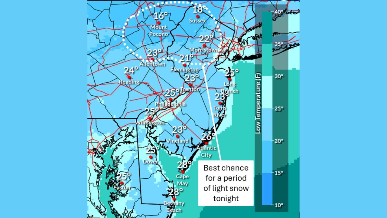
NEW JERSEY — Another cold January night is settling across New Jersey and eastern Pennsylvania, with temperatures dropping sharply into the teens and low 20s across much of the region. According to the latest forecast data, a weak disturbance passing north of the area will bring a brief window of light snow overnight, mainly affecting locations north of Interstate 78.
While this is not a major winter storm, the setup is enough to create localized slick spots, especially in higher elevations and colder inland valleys.
Light Snow Focused North of I-78
Forecast guidance shows the best chance for snow north of the I-78 corridor, including parts of:
- Northern New Jersey
- The Poconos
- Lehigh Valley
- Northwestern New Jersey and far northern Pennsylvania
Snow amounts are expected to be light, with up to a half inch of accumulation possible in the most favored spots. Many areas may see only flurries or brief snow showers, while locations farther south remain dry.
Cold Temperatures Drive Snow Potential
Temperatures overnight will be cold enough to support snow wherever precipitation develops:
- Teens across higher elevations and northwest New Jersey
- Low 20s for much of inland New Jersey and eastern Pennsylvania
- Mid to upper 20s closer to the coast and southern New Jersey
These cold surface readings increase the chance that even weak precipitation falls as snow rather than rain, particularly before daybreak.
Dry Conditions for Most of Southern New Jersey
Areas south of I-78, including southern New Jersey and coastal communities, are expected to remain dry overnight. No significant precipitation is anticipated there, though temperatures will still be cold, with lows generally in the mid to upper 20s.
What to Watch Overnight
Even minimal snowfall can cause issues when temperatures are this low. Drivers should be aware of:
- Brief slick spots on untreated roads
- Isolated icy patches on bridges and overpasses
- Reduced visibility during any passing snow showers
No widespread travel disruptions are expected, but early-morning commuters north of I-78 should use caution.
Looking Ahead
After this disturbance exits, dry weather dominates, but the cold pattern remains in place. Overnight lows stay below freezing, and any untreated wet surfaces could refreeze by morning.
What are conditions like where you live — flurries, snow showers, or just cold and dry? Share your local update and stay connected for more weather coverage.