
New Jersey, New York, and Massachusetts Set for First I-95 Snow of the Season Early Sunday Morning
BOSTON, MASSACHUSETTS — A compact coastal system is expected to slide up the Eastern Seaboard late Saturday night into Sunday morning, bringing the first widespread accumulating snow of the season to portions of New Jersey, New York, Connecticut, Rhode Island, and eastern Massachusetts along the busy I-95 corridor.
Overview: Light but Widespread Snow for the Northeast
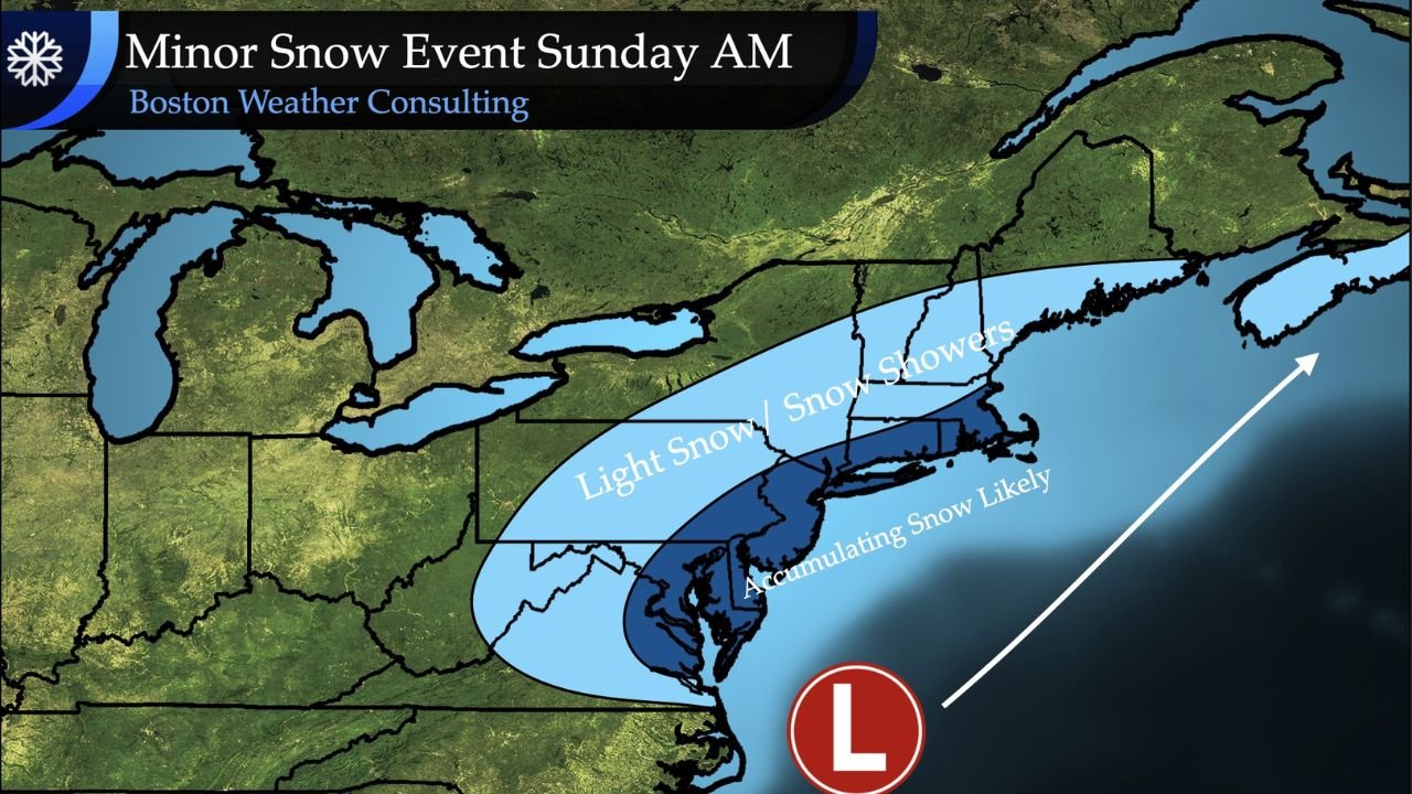
Forecast maps highlight a broad zone of light snow and snow showers stretching from the Mid-Atlantic into New England, with a more focused band of accumulating snow likely near and just inland from the coast.
Snow arrives overnight Saturday, peaks around daybreak Sunday, and gradually tapers off later in the morning and midday as the system lifts into the Atlantic.
For many communities from Philadelphia to New York City and into coastal New England, this looks to be the first measurable snow event of the season, even though totals will be modest.
Where Accumulating Snow Is Most Likely
The current outlook shows:
- A lighter snow zone arcing from western Pennsylvania and upstate New York through interior New England, where scattered snow showers and light coatings are most likely.
- A narrower band of accumulating snow hugging the coastline from eastern Maryland and Delaware through New Jersey, Long Island, southern New England, and into coastal Maine.
Within this darker band on the map, snowfall of around 1–3 inches is favored, with the best chance for the higher end of that range from southern New Jersey into parts of coastal New York and southern New England.
A small jog north or south in the track of the system could shift where the most persistent snow sets up, so exact totals will continue to be fine-tuned as the weekend approaches.
Impact on Travel, Commuters, and Early-Morning Plans
Even a “minor” event can cause issues when it arrives while most roads are at their coldest and traffic is starting to pick up.
Key impacts along I-95 and nearby cities include:
- Slippery roads early Sunday, especially on bridges, overpasses, and untreated side streets.
- Reduced visibility in pockets of steadier snow, particularly near the coast where the accumulating band passes.
- Longer travel times for early-morning workers, churchgoers, and anyone heading to load in for a gig or an early soundcheck.
With temperatures near or below freezing at the onset, even 1–2 inches of snow can quickly coat pavement, so drivers should plan on extra time and slower speeds, and consider delaying non-essential travel until later Sunday when conditions improve.
What This Means for the Rest of December
This system does not look like a blockbuster winter storm, but it does mark an important shift:
the atmosphere is now cold enough to support multiple rounds of snow when moisture lines up, especially across the Northeast.
For music fans, touring crews, and venue staff up and down the East Coast, this is a reminder that winter travel season has officially begun. As more systems line up later in December, even light events like this one can ripple through show schedules, load-ins, and regional drives between cities.
As always, if you’re planning to drive to or from a show between Washington, D.C., Philadelphia, New York City, and Boston on Sunday, keep an eye on local forecasts, allow extra time, and be ready for slick, snow-covered stretches along I-95—especially during the early-morning hours.