
New Mexico Snowpack Collapses to Record Lows After Early February Peak as Rapid March Melt Follows Historic Heat
NEW MEXICO — What should be the climatological peak of snowpack in New Mexico is instead marking one of the lowest points on record.
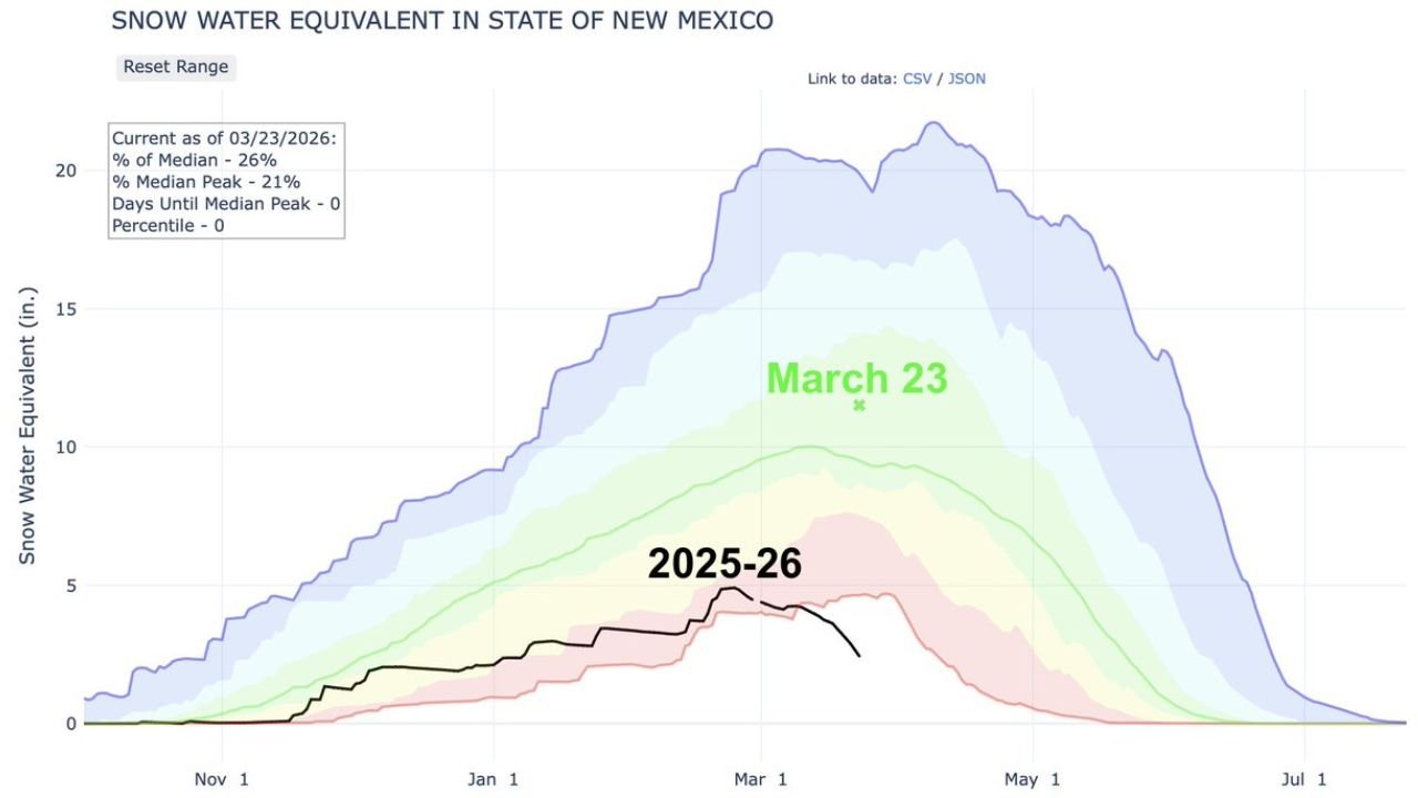
March 23 typically represents the average peak of snowpack across the state. However, data from the state’s Snow Water Equivalent (SWE) analysis shows that the 2025–2026 snow season peaked early — around February 23 — and has since undergone a rapid and historic decline.
Snowpack Now at Just 26 Percent of Median
As of March 23, 2026, statewide snow water equivalent stands at:
- 26 percent of the median
- 21 percent of the median peak
- 0 percentile ranking compared to historical records
That percentile reading indicates this is the lowest snowpack observed for this date in the dataset.
The current season’s black line on the graph remains far below the historical median (green line) and dramatically beneath the higher snowpack years shaded in blue.
Rapid Melt Since March 10
According to the timeline shown in the data, snowpack levels have been at record-low territory since March 10. The steep downward trend corresponds with a wave of record-setting heat that impacted New Mexico and much of the western United States earlier this month.
The early-season peak in late February was already below average, but sustained warmth accelerated melting weeks ahead of normal seasonal decline.
Instead of gradually tapering into April and May, snowpack began collapsing in early March.
Climatological Peak Arrives With No Snow Recovery
Under typical conditions, snowpack builds through winter and reaches its maximum around late March. This year, that benchmark arrives after the state has already lost a significant portion of its snow reservoir.
The historical range shown in the graph demonstrates that even low-snow years usually maintain higher levels into late March. The 2025–26 season stands apart due to the combination of:
- Early peak timing
- Below-average accumulation
- Rapid, heat-driven melt
Implications for Water Supply and Fire Season
New Mexico relies heavily on mountain snowpack as a natural water reservoir feeding rivers and reservoirs during spring runoff.
With snowpack already depleted well ahead of schedule, concerns increase regarding:
- Spring and summer water availability
- Irrigation supplies
- Elevated wildfire risk
The rapid melt also shortens the runoff window, potentially reducing sustained river flow later into the warm season.
A Historic March Marker
March 23 should represent New Mexico’s seasonal high-water mark in snow storage. Instead, it highlights an unprecedented collapse driven by record warmth and early-season melt.
With snowpack sitting at the bottom of the historical range and no significant recovery indicated in the data, the 2025–2026 winter will likely be remembered as one of the most deficient snow seasons on record for the state.
ChicagoMusicGuide.com will continue tracking drought, snowpack and wildfire-related developments as spring unfolds across the Southwest.