
New Year’s Eve Snowstorm Targets Pennsylvania, West Virginia, and Eastern Ohio With Hazardous Night Travel
PENNSYLVANIA — A fast-moving winter storm is set to disrupt New Year’s Eve travel across western Pennsylvania, northern West Virginia, and eastern Ohio, with the most dangerous conditions expected Wednesday evening through early Thursday morning. Forecast data shows heavy snow bands, snow squalls, and sharply reduced visibility during peak celebration and travel hours.
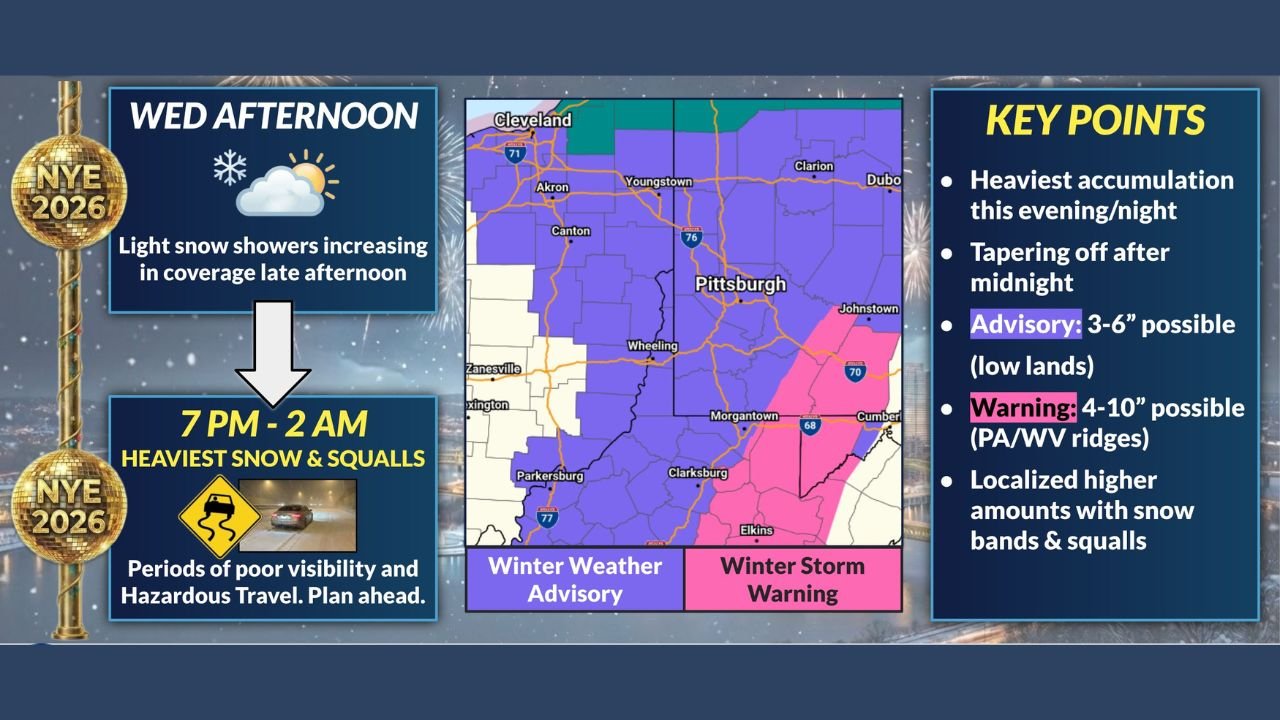
Peak Impact Window: 7 PM to 2 AM
According to the forecast timeline, snow coverage will expand Wednesday afternoon before intensifying rapidly after sunset. The heaviest snow and squalls are expected between 7 PM and 2 AM, a critical window for New Year’s Eve plans.
During this period, travelers can expect:
- Bursts of heavy snowfall
- Sudden whiteout conditions in squalls
- Rapidly deteriorating road conditions
- Hazardous driving, especially on hills and ridges
Snow intensity is forecast to ease after midnight, but lingering slick roads and reduced visibility may persist into early Thursday.
Snow Totals by Area
The data highlights a clear difference between lowland areas and higher terrain:
- Lowlands (Winter Weather Advisory areas):
3 to 6 inches of snow possible, including metro areas such as Pittsburgh and surrounding valleys. - Higher elevations and ridges (Winter Storm Warning areas):
4 to 10 inches of snow likely across the Laurel Highlands of Pennsylvania and the ridges of northern West Virginia, with locally higher amounts where snow bands persist.
These ridge-top zones are at the highest risk for dangerous travel due to stronger squalls and heavier accumulations.
Most Affected States and Regions
This storm is not nationwide and should be viewed as a regional impact event, with the strongest effects focused on:
- Western and southwestern Pennsylvania
- Northern and central West Virginia
- Eastern Ohio near the Ohio–Pennsylvania–West Virginia border
Areas farther west and south will see less impact, while locations outside this corridor may avoid significant snowfall altogether.
Travel and Safety Concerns
The combination of holiday traffic, alcohol-related travel, and sudden snow squalls makes this event especially risky. Visibility may drop quickly within heavier bands, catching drivers off guard.
Officials urge residents to:
- Avoid unnecessary late-night travel
- Plan sober rides in advance
- Allow extra time and reduce speed
- Stay alert for rapidly changing conditions
Even short trips could become hazardous during peak snowfall.
What to Expect After Midnight
While snowfall rates are expected to decrease after midnight, untreated roads may remain icy, particularly in colder, elevated areas. Cleanup and travel conditions may remain challenging into New Year’s Day morning.
If you’re celebrating New Year’s Eve in Pennsylvania, West Virginia, or eastern Ohio, plan ahead and prioritize safety over speed. Weather conditions can change quickly, and this storm is expected to peak right when many people are on the road.
For continued weather updates, regional alerts, and live safety information, stay connected with ChicagoMusicGuide.com and share this update with anyone planning late-night travel.