
New York, Boston, Philadelphia and Interior Northeast Brace for Snow and Ice Northwest of I-95 as 1040mb High Drives Sharp Thermal Clash
UNITED STATES — A classic late-winter thermal battle is setting up across the Mid-Atlantic and Northeast, with snow, ice and rain all in play as a strong ~1040mb high pressure system presses cold air southward while warmer air surges in above it.
Forecast guidance shows a pronounced cold air mass locked in across the interior Northeast, creating the potential for a messy mix — especially northwest of the I-95 corridor.
Strong 1040mb High Anchors Cold Air
A substantial high-pressure system near 1040mb is positioned to funnel dense cold air into the Northeast at low levels. Even though the high is gradually shifting, its strength is significant enough to:
- Reinforce surface cold air
- Promote cold-air damming (CAD) signatures
- Maintain subfreezing temperatures in the interior
This setup creates a shallow but stubborn cold layer near the ground.
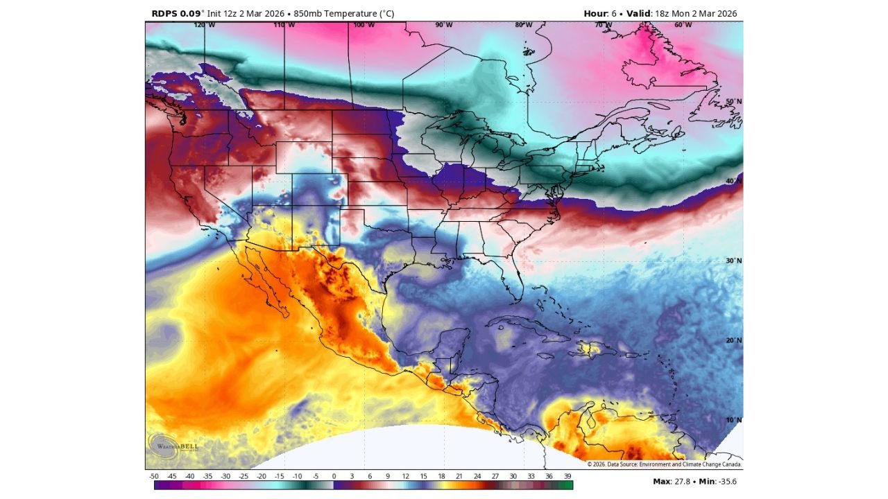
Warm Air Surges Aloft: The Setup for Ice
At the same time, warmer air is projected to override the surface cold dome. The 850mb temperature map shows:
- Deep cold air entrenched across Upstate New York, interior Pennsylvania and New England
- A sharp temperature gradient pushing north from the Mid-Atlantic
- Warmer air advancing above the surface layer
This vertical temperature structure is a red flag for:
- Freezing rain
- Sleet transitions
- Rapid precipitation-type changes
Greatest Snow and Ice Risk: Northwest of I-95
Based on the thermal profile, the highest risk for disruptive winter weather appears to be northwest of much of Interstate 95, including areas such as:
- Interior Pennsylvania
- The Hudson Valley
- Interior New York State
- Western Massachusetts
- Interior Connecticut
- Southern and central New England
Meanwhile, major I-95 cities like:
- New York City
- Philadelphia
- Boston
- Washington, D.C.
may see more mixing or rain at times, depending on how quickly surface cold air erodes.
Snowpack and Cold Air Reinforcement
Existing snowpack across portions of the Northeast enhances the cold-air damming effect. Snow cover helps:
- Maintain lower surface temperatures
- Reduce daytime warming
- Strengthen the low-level cold pool
This increases the likelihood that interior areas remain locked into snow or ice longer than coastal zones.
A True Thermal Clash
The pattern illustrates a classic boundary between:
- A notable cold air mass anchored across the Northeast
- Warmer air lifting northward from the South
This kind of clash often leads to sharp gradients — where one county sees heavy snow while another experiences plain rain.
Bottom Line
A strong 1040mb high and entrenched cold air mass are setting the stage for a complicated winter weather event across the Mid-Atlantic and Northeast.
Expect a snowy and icy mess northwest of I-95, with interior Pennsylvania, Upstate New York and New England most at risk for significant winter impacts. Coastal cities may see more rain or mixed precipitation, but shifts in the cold air depth could change that quickly.
ChicagoMusicGuide.com will continue tracking this developing Northeast storm and any updates to precipitation type forecasts as the event unfolds.