
New York, Pennsylvania and Massachusetts Brace as Nor’easter Snow Bands Shift East, Subsidence Trims Totals in Upstate NY and East-Central PA
ALBANY, NEW YORK — A powerful February 22–23, 2026 Nor’easter is unfolding across the Northeast, but updated analysis shows snowfall trends shifting slightly east compared to earlier forecasts. While major cities like New York City and Boston, Massachusetts remain in the 16–24+ inch zone, areas across Upstate New York and East-Central Pennsylvania are seeing reduced totals as subsidence cuts into snow bands.
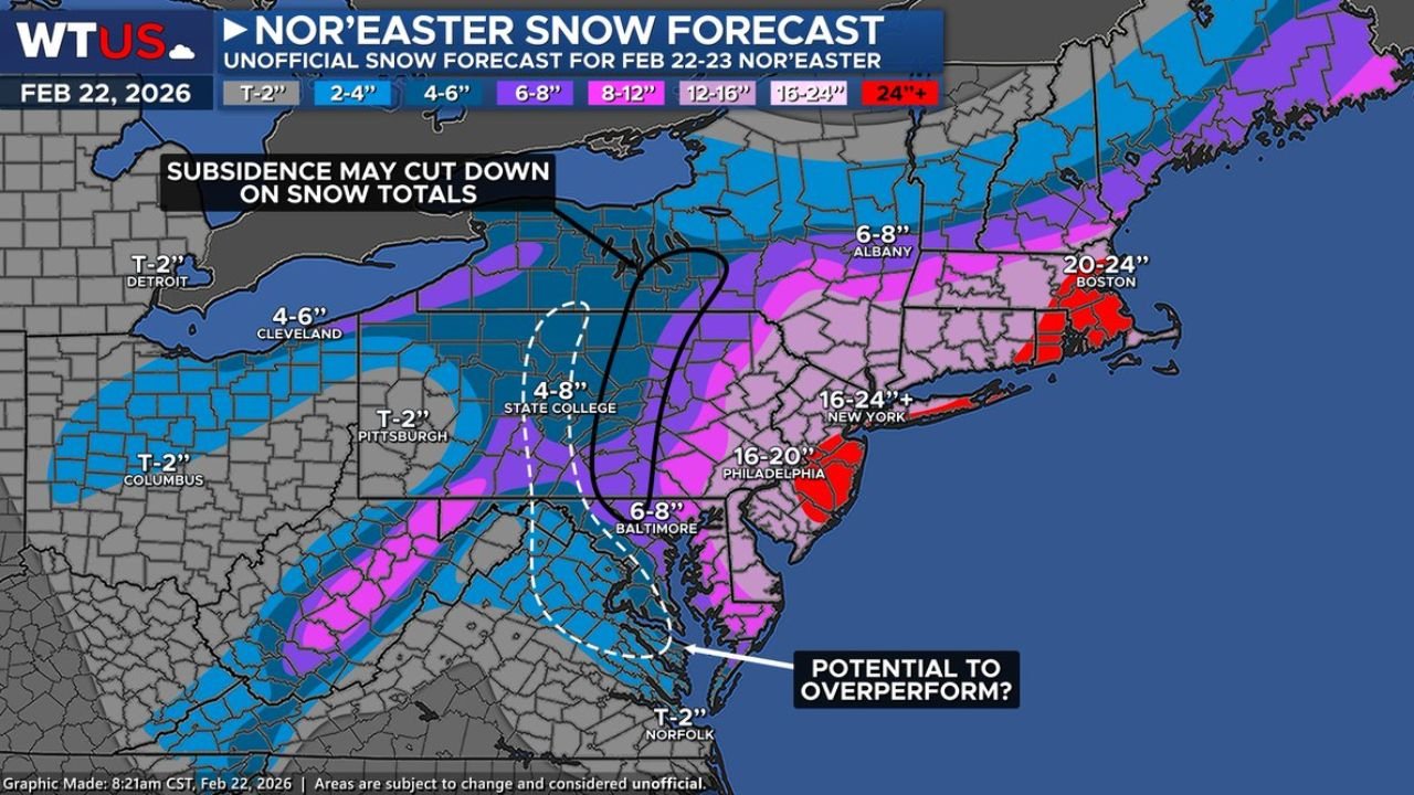
Forecasters note that while the 24-inch-plus snowfall outline is verifying well along parts of the coast, interior zones are not receiving quite as much as initially projected.
Subsidence Limits Snow in Upstate New York and East-Central Pennsylvania
Updated forecast graphics highlight a zone of subsidence — sinking air that suppresses heavy snowfall — stretching across Upstate New York and into East-Central Pennsylvania, including areas near State College.
Earlier projections suggested stronger deformation banding in these regions, but totals now appear closer to:
- 4–8 inches near State College, PA
- 6–8 inches near Albany, NY
- 4–6 inches in parts of western New York
The snowfall gradient is sharp. Just east of the subsidence zone, totals climb rapidly into double digits.
This eastward adjustment means the heaviest snow core is aligning more precisely along the coastal corridor.
Coastal Cities Remain in the 16–24+ Inch Bullseye
While interior areas see trimmed totals, coastal hubs remain firmly in the high-impact zone. Current snowfall projections indicate:
- 16–24+ inches in New York City, NY
- 16–20 inches in Philadelphia, PA
- 20–24 inches in Boston, MA
- 6–8 inches in Baltimore, MD
Parts of eastern Massachusetts, including areas south and east of Boston, sit within the 20–24 inch range, with isolated pockets potentially exceeding that mark if banding stalls.
The 24-inch contour along portions of the Massachusetts coastline is verifying “almost perfectly,” according to forecast comparisons.
Deformation Band Sets Up — But Not as Far South
The storm’s deformation band, responsible for the heaviest snowfall rates, has developed as expected — but its placement is slightly farther north than initially predicted.
Earlier forecasts suggested stronger banding deeper into southern Pennsylvania and possibly farther south toward Maryland and northern Virginia. Instead, the most consistent heavy snow axis runs from:
- Central Pennsylvania
- Through Upstate New York
- Into eastern Massachusetts
Areas near Norfolk, Virginia, are expected to remain on the lower end with totals under 2 inches, well south of the core snow shield.
This subtle northward shift explains why some parts of East-Central Pennsylvania are underperforming compared to early expectations.
Sharp Snowfall Cutoffs Highlight Storm Complexity
One of the most striking features of this Nor’easter is the dramatic snowfall cutoff. In parts of:
- Detroit, Michigan – under 2 inches
- Columbus, Ohio – under 2 inches
- Pittsburgh, Pennsylvania – around 1–2 inches
Yet just a few hours east, totals increase significantly.
This tight gradient underscores the complex interaction between coastal low pressure, upper-level energy, and subsidence zones that can suppress snow on the western flank of the storm.
Meteorologists continue monitoring whether portions of the Mid-Atlantic could still “overperform” if banding shifts slightly west.
A High-Impact Event for the Northeast Corridor
Despite some interior reductions, this remains a high-impact Nor’easter for major population centers in New York, Massachusetts, and parts of Pennsylvania.
Heavy snowfall rates, strong coastal winds, and travel disruptions are expected across the I-95 corridor from Philadelphia through New York City and into Boston.
With the storm still evolving, localized banding could push totals higher in isolated areas, particularly across eastern Massachusetts and coastal New York.
As communities across New York, Pennsylvania, and Massachusetts monitor changing snowfall totals, residents are urged to follow local advisories and avoid unnecessary travel during peak snowfall periods.
For continuing coverage of major winter storms, regional weather impacts, and Northeast travel updates, visit ChicagoMusicGuide.com.