
New York, Pennsylvania and Massachusetts Could See Significant Snow as Saturday Night–Monday Winter Storm Targets Northeast
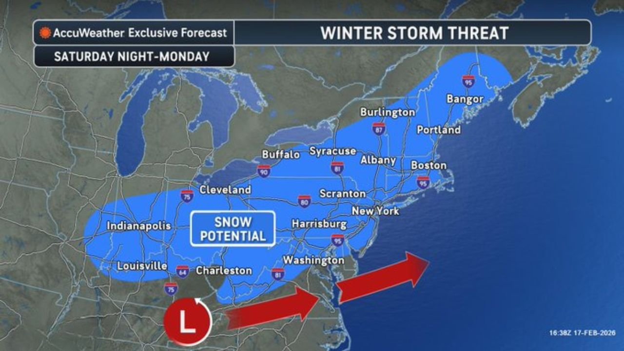
NEW YORK, NEW YORK — A developing Saturday night into Monday winter storm has the potential to bring significant snowfall to a large portion of the Northeastern United States, including New York City, Philadelphia, Boston, and Albany. Forecast guidance indicates a coastal low pressure system will track near the Mid-Atlantic before lifting northeast, placing a broad region in the zone of snow potential.
While exact snowfall totals are still being refined, the projected storm track supports a multi-state snow event stretching from the Ohio Valley through the Mid-Atlantic and into New England.
Snow Potential Extends from Midwest to New England
The projected snow shield covers a wide corridor, including Indianapolis, Louisville, Cleveland, Buffalo, Scranton, Harrisburg, Albany, Boston, Portland, and Bangor.
Cities along the Interstate 95 corridor, including Washington, D.C., New York City, and Boston, fall within the broader snow potential area. Inland locations such as Buffalo and Syracuse may also see accumulating snow depending on final storm intensity.
The system is expected to organize Saturday night and continue impacting the region through Sunday and into early Monday.
Coastal Low Track Will Determine Heaviest Snow Band
A developing low-pressure system off the Southeast coast is forecast to move northeastward. The exact path of this low will determine where the heaviest snow axis sets up.
If the storm tracks slightly closer to the coast, snowfall could be more substantial across New Jersey, eastern Pennsylvania, southern New York, and Massachusetts.
If it tracks farther offshore, snowfall totals could be lighter near the coast but heavier across interior sections including upstate New York and northern New England.
Even modest shifts in the storm’s position could significantly alter snowfall totals across major metro areas.
Major Cities in the Snow Zone
The highlighted snow potential area includes:
- New York City, New York
- Philadelphia, Pennsylvania
- Boston, Massachusetts
- Albany, New York
- Buffalo, New York
- Scranton, Pennsylvania
- Harrisburg, Pennsylvania
Farther south, Washington, D.C. and parts of Maryland may also see accumulating snow, though amounts could depend on temperature profiles and timing.
Saturday Night Through Monday Impact Window
The primary impact window begins Saturday night as precipitation spreads northward. Snow may intensify Sunday as the storm strengthens offshore, before tapering off Monday.
Travel disruptions are possible along major highways, including I-95, I-80, and I-90, particularly if heavier snowfall bands develop.
At this stage, forecasters emphasize that confidence is high in a storm affecting the region, but specific snowfall amounts remain uncertain.
What Residents Should Do Now
Residents across New York, Pennsylvania, New Jersey, Massachusetts, and the broader Northeast should monitor forecast updates through the week. As the system moves within three days, model confidence will increase and more precise snowfall projections will be available.
With several large metro areas in the potential impact zone, even moderate snowfall could lead to widespread travel delays.
ChicagoMusicGuide.com will continue tracking this developing Northeast winter storm and provide timely updates on storm track, snowfall expectations, and regional impacts. For ongoing winter weather coverage across the United States, visit ChicagoMusicGuide.com.