
New York, Pennsylvania, Virginia and North Carolina Wind Event Validates Moderate Risk as 57–72 MPH Gusts Dominate March 16 Outbreak Despite Tornado Shortfall
UNITED STATES — A major severe weather event on March 16, 2026, stretching from North Carolina and Virginia through Pennsylvania and into New York, is now being closely analyzed—and despite public perception, data shows the Moderate Risk forecast was largely accurate, driven by widespread damaging winds rather than tornadoes.
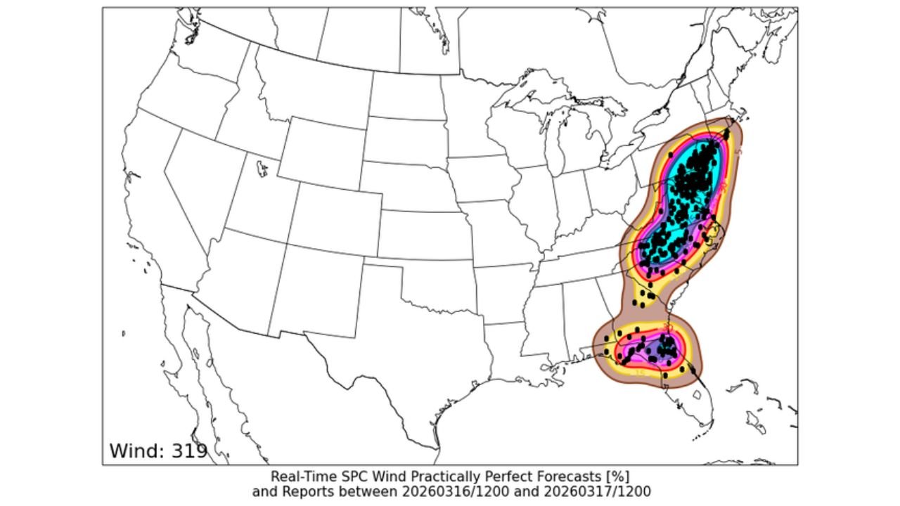
While many expected a larger tornado outbreak, meteorological data confirms that the primary hazard—damaging wind—verified strongly across the Eastern United States, with dozens of reports in the 57–72 mph range.
Wind Damage Across North Carolina, Virginia, Pennsylvania and New York Led the Event
Storm reports and forecast verification maps show a clear corridor of intense wind activity running from the Carolinas through the Mid-Atlantic and into the Northeast.
This region—including North Carolina, Virginia, Pennsylvania, and New York—experienced numerous wind reports, many of which fell squarely within the expected severe criteria range.
More than 88 verified wind reports between 57 and 72 mph were recorded, aligning closely with forecast expectations for a Moderate Risk day.
Why the Moderate Risk Forecast Was Considered Accurate
Despite criticism centered around a perceived “tornado bust,” the data tells a different story. Forecast models had emphasized a strong wind-driven event, and that scenario ultimately played out.
The Storm Prediction Center’s outlook included a 60% wind probability (CIG 1)—a level that typically corresponds to a Moderate Risk designation. Additional forecast tools even suggested 75% probabilities, reinforcing confidence in a high-impact wind event.
In severe weather forecasting, a Moderate Risk does not require widespread tornadoes—it reflects the overall threat level, including damaging winds, which were clearly realized in this case.
Understanding the Wind Speed Distribution From the Event
Statistical breakdowns of wind reports provide further clarity. Historical and real-time data show that:
- 57–72 mph winds occur in over 85% of CIG 1 wind events
- Winds exceeding 73 mph occur only about 13% of the time
This means that while extreme gusts above 75 mph are less common, the more frequent 57–72 mph range still represents significant and damaging severe weather.
During the March 16 outbreak, the majority of reports fell precisely within this expected range, confirming that the event behaved in line with climatological expectations.
Forecast vs Reality: Strong Alignment in Wind Corridor
Comparisons between forecast outlook maps and actual storm reports show a remarkably strong alignment, particularly across the Eastern Seaboard from the Southeast into the Northeast.
The highest probabilities for damaging winds overlapped closely with the areas that ultimately saw the most reports, including Virginia, Maryland, Pennsylvania, and New York.
This level of accuracy highlights the effectiveness of modern severe weather forecasting, especially when evaluating wind-driven systems rather than tornado-focused setups.
Why Tornado Expectations Didn’t Materialize as Expected
Although tornado warnings were issued, the overall tornado threat did not reach the same level as the wind threat. This led to some public perception that the event underperformed.
However, tornado development depends on more specific atmospheric conditions, and even within high-risk setups, outcomes can vary. In this case, wind shear and storm structure favored damaging straight-line winds over widespread tornado formation.
This distinction is critical in understanding why the Moderate Risk was still justified, even without a major tornado outbreak.
A Key Lesson in Severe Weather Forecast Interpretation
This event underscores an important point: severe weather risk categories are not tornado-only indicators. Wind, hail, and overall storm coverage all contribute to the final outlook.
The March 16 outbreak across North Carolina, Virginia, Pennsylvania, and New York serves as a strong example of how damaging winds alone can validate a high-end forecast.
As severe weather season continues, understanding these nuances will be key for both the public and forecasters alike.
For continued in-depth analysis of major weather events across the United States, stay connected with ChicagoMusicGuide.com.