
NHC Issues Final Report on Tropical Storm Jerry After Deadly Flooding in Guadeloupe and Significant Impacts to the Leeward Islands
UNITED STATES — The National Hurricane Center has released its official post-analysis report on Tropical Storm Jerry, confirming that the early-October system caused significant flooding across portions of the Leeward Islands, with one fatality reported in Guadeloupe. The review, published December 17, provides the final track, intensity estimates, and impacts associated with the storm, which lasted from October 7 to October 11, 2025.
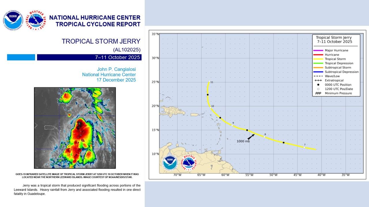
Tropical Storm Jerry’s Track and Development
According to the NHC’s Tropical Cyclone Report, Jerry developed over the open Atlantic before tracking west-northwest toward the northern Leeward Islands.
The storm maintained tropical-storm strength, following a curved path near the islands from October 7 to 11.
Satellite analysis shows persistent deep convection, with strong thunderstorm activity clustered east of the circulation.
Jerry never strengthened into a hurricane, but its slow movement and moisture-laden bands created an ideal setup for prolonged heavy rainfall.
Flooding Impacts Across the Leeward Islands
The storm produced damaging, widespread flooding across several islands — most notably Guadeloupe, where runoff and flash flooding from continuous rainfall contributed to the death of one resident, confirmed by local officials and highlighted in the NHC report.
Several islands experienced:
- Urban and flash flooding
- Washed-out roads
- Localized landslides
- Damage to homes and small businesses
While Jerry’s winds were not extreme, its rainfall footprint caused substantial hydrological impacts, especially in mountainous and low-lying terrain.
Why Jerry Was So Flood-Productive
Meteorologists note that Jerry’s structure resembled a moisture-rich tropical disturbance with sustained thunderstorms repeatedly training over the same regions.
Key factors included:
- Slow forward motion, increasing rainfall duration
- High atmospheric moisture, enhancing rainfall rates
- Topographic enhancement, especially over the Leeward Islands’ elevated terrain
These ingredients produced rainfall totals far exceeding what is typical for a weak tropical storm.
NHC’s Final Assessment and Availability of the Report
The Tropical Cyclone Report includes detailed maps of Jerry’s track, intensity timeline, and pressure evolution, as well as infrared satellite imagery showing the storm’s peak organization. The report is now publicly available through the National Hurricane Center’s data portal.
The NHC’s findings serve as the definitive meteorological record for Tropical Storm Jerry’s development and impacts, closing the books on one of the more flood-intense tropical storms of the 2025 Atlantic season.
Have a weather story, storm photo, or local update to share?
Stay connected with ChicagoMusicGuide.com for ongoing weather coverage and community updates.