
NOAA Day 3–7 Hazards Outlook Flags Dangerous Cold and High Winds for Illinois, Michigan, Ohio, New York and New England States Through February 11
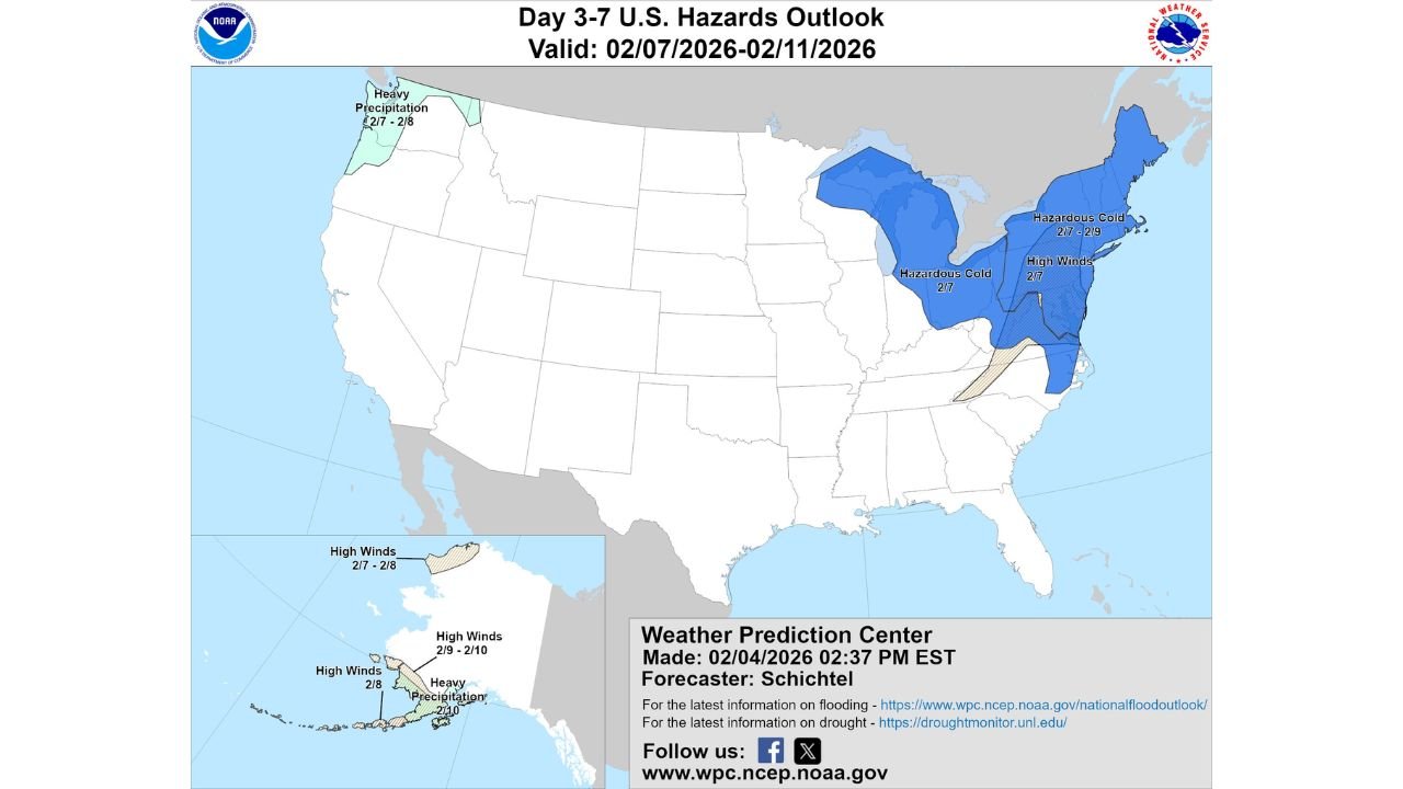
UNITED STATES — An updated NOAA Weather Prediction Center Day 3–7 U.S. Hazards Outlook is highlighting a significant winter weather threat across the Midwest and Northeast, with hazardous cold and strong winds expected to impact Illinois, Michigan, Ohio, Pennsylvania, New York, and New England between February 7 and February 11, 2026. The outlook also flags additional hazards in the Pacific Northwest and Alaska, pointing to an active and potentially disruptive national weather pattern.
Hazardous Cold Spreads Across the Great Lakes and Midwest
The outlook shows a large zone of hazardous cold developing across the Great Lakes region, including Illinois, Michigan, Wisconsin, Indiana, and Ohio, beginning around February 7. Cold air then expands eastward into Pennsylvania and upstate New York as the period progresses.
This level of cold typically signals multiple days of well-below-normal temperatures, increasing the risk of frostbite, hypothermia, and added strain on heating systems, power infrastructure, and water lines. In metro areas such as Chicago, Detroit, and Cleveland, prolonged cold can also lead to slick road conditions, increased vehicle issues, and challenges for late-night travel.
High Winds Increase Risks Across New York and New England
Alongside the cold, the hazards outlook highlights high winds across much of the Northeast, including New York, Vermont, New Hampshire, Massachusetts, and Maine, particularly on February 7. When combined with already cold temperatures, these winds may produce dangerously low wind chills.
High wind events raise the potential for downed trees, scattered power outages, and difficult driving conditions, especially for high-profile vehicles. Exposed areas, coastal zones, and higher terrain across New England are especially vulnerable during these setups.
Heavy Precipitation Targets Washington and Oregon
While cold dominates the central and eastern U.S., the outlook also flags heavy precipitation for portions of Washington and northwestern Oregon from February 7 to February 8. Winter systems in this region often bring heavy rain at lower elevations and substantial snowfall in the Cascades.
These conditions can lead to river rises, localized flooding, and mountain pass travel disruptions, particularly if snow levels fluctuate. The signal suggests an active Pacific storm track operating simultaneously with the eastern cold outbreak.
Multiple Weather Hazards Continue Across Alaska
The hazards map also highlights Alaska, where areas are marked for high winds from February 7 through February 10, along with heavy precipitation around February 10. These hazards can significantly impact aviation, marine travel, and supply routes for remote communities, making timing and preparedness critical.
Why This Matters for Travel, Concerts, and Events
The Day 3–7 Hazards Outlook focuses on identifying potentially impactful weather, not exact temperature or wind values. However, the size and persistence of the cold and wind zones across Illinois, Michigan, Ohio, New York, and New England suggest a high-confidence winter pattern, rather than a brief cold snap.
For fans planning concert travel, live shows, or regional events—especially across the Chicago area, the Great Lakes, and the Northeast corridor—this outlook signals the need for weather-aware planning. Cold extremes and strong winds can affect transportation schedules, venue operations, and overall attendance, particularly during evening hours.
As February continues, updated outlooks and short-range forecasts will refine the timing and intensity, but the broader message remains clear: mid-February is shaping up to be an active and potentially hazardous winter period across large portions of the United States.
For continued weather updates, regional impact breakdowns, and how upcoming conditions could affect concerts and travel, visit ChicagoMusicGuide.com.