
NOAA’s May–July 2026 Seasonal Outlook Signals a Hot, Dry Summer for the West and a Short but Potentially Explosive Severe Weather Season for the Plains
DENVER, CO — Summer 2026 is shaping up to be a tale of two Americas — and the data released by NOAA on March 19, 2026 is making that divide impossible to ignore. A scorching, below-normal precipitation pattern is locked in across the West and Northern Plains, while a rapid La Niña to El Niño climate transition is quietly setting the stage for what could be a short but dangerously active severe weather season across the Central Plains this May and June.
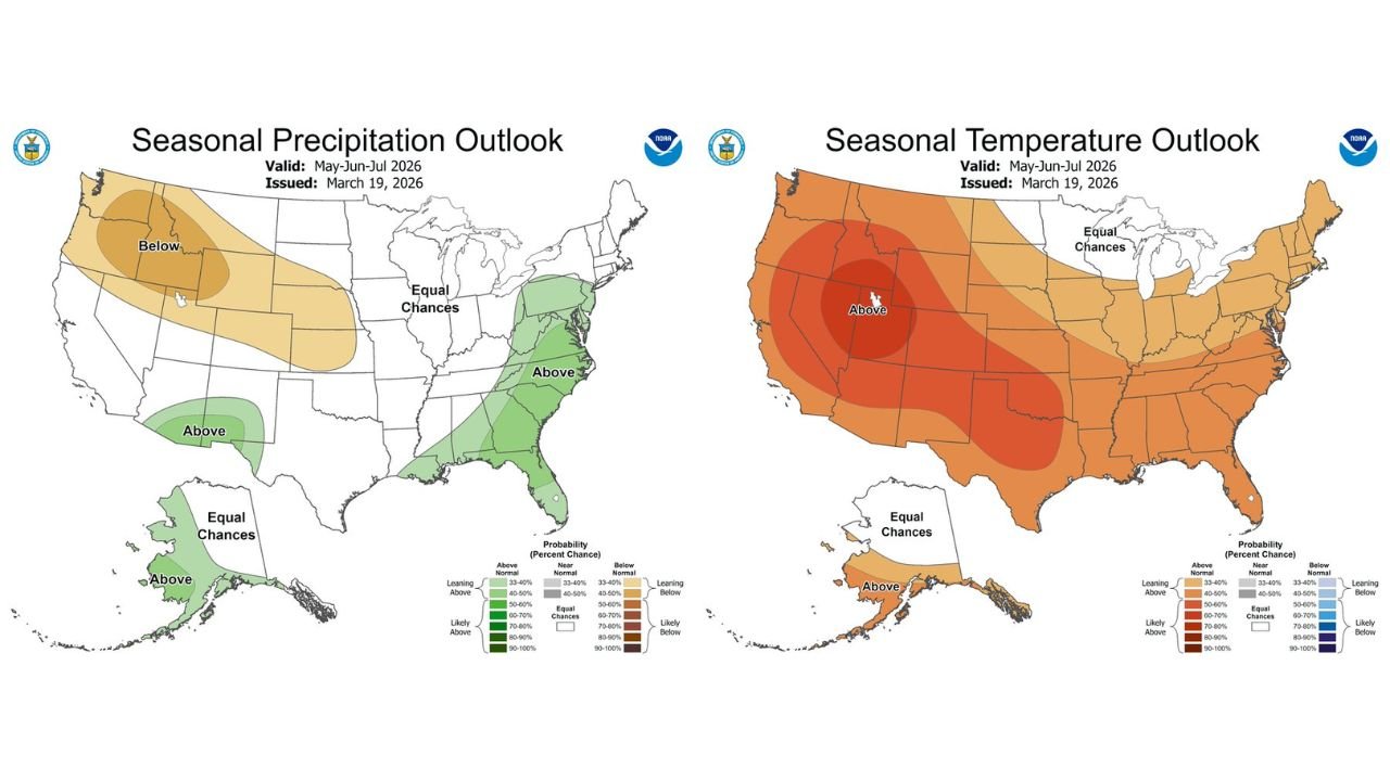
NOAA’s Official Seasonal Outlook: What the Maps Are Showing
The Climate Prediction Center (CPC) issued its Seasonal Precipitation and Temperature Outlook on March 19, 2026, valid for the May–June–July 2026 window. The two maps together tell a story that every resident from Colorado to the Carolinas needs to understand heading into the warm season.
Seasonal Precipitation Outlook — Key Signals:
- Pacific Northwest, Northern Rockies, Northern Plains — Wyoming, Montana, Idaho, Oregon, Nebraska: Flagged at 40–70% probability of below-normal precipitation through summer. This is the driest signal on the entire national map and raises serious concerns for drought expansion, wildfire risk and water supply across the region.
- Central U.S. — Kansas, Oklahoma, Missouri corridor: Sitting in the equal chances zone — no strong wet or dry signal. This is actually a critical area to watch given the La Niña to El Niño transition underway.
- Southeast and Mid-Atlantic — Georgia, Carolinas, Virginia, New Jersey: Showing 40–60% probability of above-normal precipitation through summer. Wet pattern likely to persist for the East Coast corridor.
- Southern Texas and Gulf Coast: Above-normal precipitation signal at 40–50% probability.
- Alaska: Above-normal precipitation expected across most of the state.
Seasonal Temperature Outlook — Key Signals:
- The West — California, Nevada, Utah, Colorado, Arizona, New Mexico: Deep red on the temperature map — 70–90%+ probability of above-normal temperatures through summer. This is the hottest signal on the national map and covers a massive geographic footprint.
- Southern Plains — Texas, Oklahoma, Kansas: Running 60–80% probability of above-normal temperatures. Combined with the equal-chances precipitation signal, this region faces a high heat and potential drought combination.
- Midwest and Great Lakes — Illinois, Indiana, Ohio, Michigan: 40–50% probability of above-normal temperatures — leaning warm but not extreme.
- Northeast corridor: Equal chances to leaning above normal. No extreme heat signal at this range.
- Alaska: Above-normal temperatures expected — consistent with long-term Arctic warming trends.
The La Niña to El Niño Transition — This Is the Wild Card
Here is where this seasonal outlook gets significantly more complex — and more important for anyone living in the Central and Southern Plains. The data is pointing toward a rapid La Niña to El Niño climate transition currently underway in the Pacific Ocean. Historically, this kind of transition during late winter and early spring carries a specific and well-documented severe weather signature.
What history tells us about rapid La Niña to El Niño transitions:
Dry winters across the Plains followed by a sudden shift toward El Niño conditions have repeatedly produced short but intense bursts of severe weather activity — particularly concentrated in May and June. The jet stream, which had been suppressed and displaced during La Niña, surges back with renewed energy as El Niño takes hold. That surge of jet stream energy colliding with the warm, moist Gulf air already being pulled northward by rising temperatures creates precisely the atmospheric setup that produces significant tornado and severe thunderstorm outbreaks.
The pattern being flagged here is not a guaranteed severe season — it is a compressed one. Instead of a prolonged April through June severe weather window, the signal points toward a shorter but potentially more intense burst of activity concentrated in May and June 2026.
Seasonal Outlook Confidence Table
| Region | Precipitation Signal | Temperature Signal | Confidence |
|---|---|---|---|
| Pacific Northwest / N. Rockies | Below Normal 40–70% | Above Normal 70–90% | 🔴 High |
| Southern Plains — TX, OK, KS | Equal Chances | Above Normal 60–80% | 🟠 Moderate-High |
| Southeast / Mid-Atlantic | Above Normal 40–60% | Leaning Above Normal | 🟡 Moderate |
| Midwest / Great Lakes | Equal Chances | Leaning Above 40–50% | 🟡 Moderate |
| Central Plains — Severe Season | Transition Zone | Heat Building | ⚠️ Watch May–June |
State-by-State Summer Outlook
🔴 Colorado, Utah, Nevada, California — Hottest and driest signal in the nation. Extreme heat and drought expansion likely through summer. Wildfire risk elevated significantly heading into June and July.
🟠 Montana, Wyoming, Idaho, Oregon, Nebraska — Below-normal precipitation at 40–70% probability. Water supply concerns, agricultural stress and above-normal fire weather risk through the warm season.
🟠 Texas, Oklahoma, Kansas — High heat signal combined with uncertain precipitation. La Niña to El Niño transition makes this the most volatile region for severe weather in May and June. Watch this zone closely.
🟡 Illinois, Indiana, Ohio, Michigan — Leaning warm but no extreme signal. Equal chances on precipitation. Potential for severe weather interaction if Plains energy tracks northeast during transition period.
🟢 Georgia, Carolinas, Virginia, New Jersey — Above-normal precipitation most likely outcome. Wetter and more active pattern expected through summer for the Southeast and Mid-Atlantic.
Bottom Line: Plan for Heat in the West, Severe Storms in the Plains
NOAA’s March 19 seasonal outlook is not subtle. The West is heading into a hot, dry summer. The Plains are sitting inside a climate transition that history says can produce dangerous bursts of severe weather. And the East Coast is looking at a wetter-than-normal warm season. The details will sharpen as May approaches — but the broad strokes of Summer 2026 are already being written.
Watch the May and June window across the Central and Southern Plains closely. If the La Niña to El Niño transition accelerates on schedule, the severe weather season may be short — but it may also hit hard and fast.
Data Sources: NOAA/CPC Seasonal Precipitation Outlook — Issued March 19, 2026, Valid May–July 2026 | NOAA/CPC Seasonal Temperature Outlook — Issued March 19, 2026, Valid May–July 2026
Stay Ahead of Every Major Weather Pattern This Summer
More severe heat, drought and storm events are already on the horizon for 2026. Stay informed at ChicagoMusicGuide.com — your source for breaking weather analysis, seasonal outlooks and severe storm alerts across the United States, updated as the pattern evolves.