
North Carolina, South Carolina, Alabama Face Arctic Cold Blast as Rare Fluffy Snow Ratios Spike This Weekend
UNITED STATES — A fresh surge of Arctic air is pushing into the Southeast this weekend, bringing a sharp drop in temperatures and a low-impact but unusually fluffy snow potential focused mainly on the Carolinas, while much of the Deep South deals with bitter cold rather than snow.
Forecast data shows the cold front arriving Friday night into Saturday, with the coldest air settling in by early Saturday morning and lingering through Sunday. While snowfall will be limited in coverage, snow-to-liquid ratios are abnormally high, meaning even minimal moisture could briefly produce visible snow in colder zones.
Arctic Air Pushes Deep Into the Southeast
Temperature guidance shows Arctic air spilling southward into North Alabama, Georgia, South Carolina, North Carolina, and parts of Tennessee, with early Saturday morning temperatures dropping into the single digits and teens in colder interior locations.
Wind chill data indicates sub-zero apparent temperatures across parts of northern Alabama and Tennessee, with single-digit wind chills extending southward into central Alabama and northern Georgia.
This cold air mass is comparable to what many areas experienced earlier in the week, reinforcing a prolonged cold pattern rather than a brief chill.
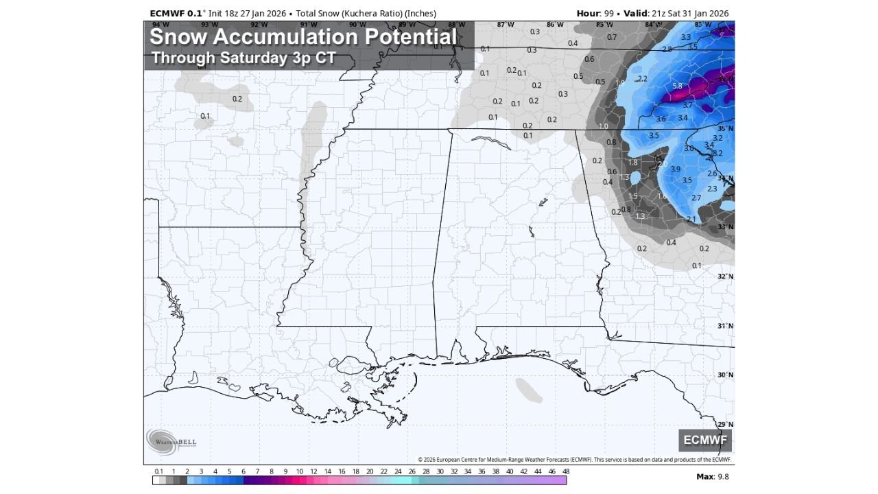
Snow Potential Remains Limited but Notable in the Carolinas
Snow accumulation maps show very limited accumulation across Alabama, Mississippi, and Georgia, with no meaningful accumulation expected in those states.
The only region showing measurable snow potential is central and eastern North Carolina, where light snow amounts could reach 1 to 3 inches in localized bands, primarily east of the Appalachian foothills.
Elsewhere in the Southeast, any snow activity would likely fall as brief flurries or light snow showers, producing little to no accumulation.
Why This Snow Would Be Different: Extremely High Snow Ratios
The standout signal in the data is the snow-to-liquid ratio, especially across the Carolinas.
Forecast ratios approach 16:1 to 17:1, nearly double the region’s typical 8:1 ratio. This means:
- Just 0.10 inches of liquid moisture could translate to 1.5 to 1.7 inches of snow
- Snow would be dry, powdery, and very fluffy
- Visibility could briefly drop during snow bursts despite low total precipitation
This kind of ratio is uncommon for the Southeast and is directly tied to the unusually cold air mass in place.
Alabama: Cold Dominates, Not Snow
Despite some speculation earlier in the week, the data does not support meaningful snowfall in Alabama.
Forecast guidance shows:
- A few sprinkles or flurries possible Friday
- No accumulation expected
- The primary impact being cold temperatures, not winter precipitation
Northern Alabama could see single-digit lows by Sunday morning, with widespread hard freezes extending across the state.
What to Watch Through the Weekend
- Friday night: Arctic front moves through, temperatures falling rapidly
- Saturday morning: Coldest temperatures and strongest wind chills
- Saturday afternoon: Isolated flurries possible, mainly east
- Sunday morning: Another hard freeze across much of the Southeast
While this system will not produce a major winter storm for most areas, the combination of deep cold and unusually efficient snow production makes it a setup worth monitoring—especially for the Carolinas.
Stay with ChicagoMusicGuide.com for continued winter weather updates, regional impacts, and cold-weather safety coverage as this Arctic pattern evolves.