
North Carolina, South Carolina, and Virginia Face Intensifying Winter Storm With Blizzard Conditions, Historic Snowfall, and Coastal Flooding Risks
UNITED STATES — A rapidly intensifying Eastern U.S. winter storm is unfolding across the Southeast and Mid-Atlantic, delivering heavy snow, powerful winds, coastal flooding, and dangerous cold as it strengthens offshore. Forecast data shows significant impacts continuing into early Sunday, with eastern North Carolina facing the highest risk of potentially historic snowfall and near-blizzard conditions.
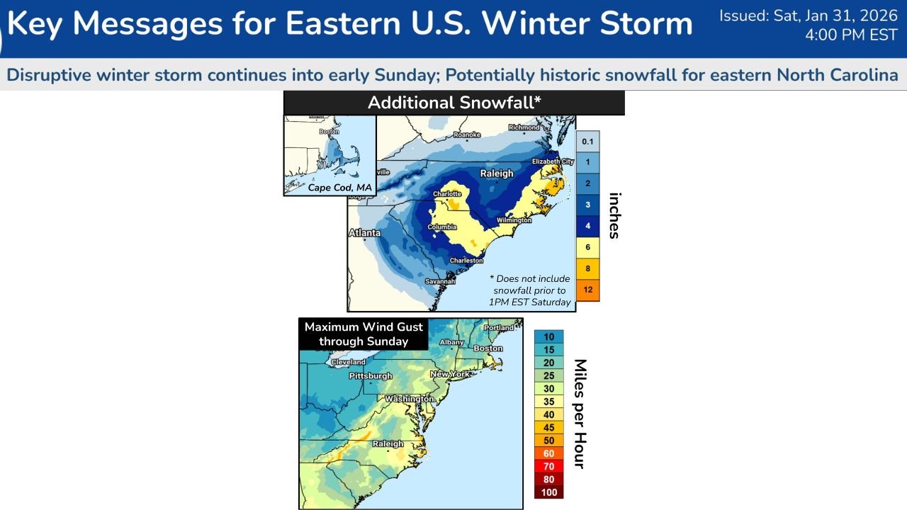
Major Winter Storm Strengthening Along the East Coast
Meteorologists report that a coastal low-pressure system positioned just off the North Carolina coast is rapidly intensifying, spreading widespread heavy snow and strong winds from the southern Appalachians through eastern Georgia, the Carolinas, and into southeastern Virginia.
Snow totals have already reached 4 to 8 inches across parts of the southern Appalachians and western North Carolina, with 3 to 6 inches observed along portions of the Crystal Coast. As the storm strengthens overnight, additional snowfall of 4 to 8 inches is expected, with a 30–50% chance of totals exceeding 12 inches across portions of eastern North Carolina.
Forecasters warn that snowfall rates could become intense, leading to rapidly deteriorating travel conditions through the overnight hours and into Sunday morning.
Near-Blizzard Conditions Possible Along the Coast
One of the most serious threats from this storm is the potential for near-blizzard to blizzard conditions along the coast from South Carolina’s Grand Strand northward through far southeastern Virginia.
Sustained winds combined with heavy snowfall may produce whiteout conditions, drastically reducing visibility. Blowing and drifting snow is expected to make road travel extremely dangerous, particularly along exposed coastal routes and bridges.
Officials caution that power outages are possible, especially where wet, heavy snow combines with strong onshore wind gusts, placing stress on power lines and trees. Emergency crews across coastal communities remain on alert as conditions worsen overnight.
Coastal Flooding Risk Increases With High Winds and Tides
In addition to snow and wind, coastal flooding poses a major concern. Forecasts show storm-force wind gusts exceeding 60 mph coinciding with astronomically high tides from the Outer Banks of North Carolina north to the Virginia Capes.
These conditions could lead to significant coastal flooding, including road closures, flooded homes and businesses in low-lying areas, and accelerated beach erosion. Emergency managers urge residents in vulnerable coastal zones to prepare for possible evacuations or restricted travel as water levels rise.
Record Cold Follows the Storm System
Behind the storm, a surge of Arctic air is expected to sweep across the Southeast and Mid-Atlantic, bringing record-challenging cold temperatures into early next week.
Forecasts indicate dangerously low wind chills, with readings near or below zero in some areas through Tuesday. Officials warn that prolonged exposure to the cold could pose serious health risks and exacerbate recovery efforts following the storm.
The combination of deep snowpack, lingering power outages, and extreme cold may prolong impacts well beyond the storm’s departure.
Travel and Safety Concerns Across Multiple States
Transportation officials urge residents across affected states to avoid unnecessary travel, particularly overnight and early Sunday. Snow-covered roads, blowing snow, and reduced visibility could lead to accidents, road closures, and delayed emergency response times.
Air travel may also be disrupted at major hubs along the East Coast as airlines adjust schedules in response to deteriorating weather conditions.
Residents are encouraged to monitor local alerts, prepare emergency kits, and ensure access to heating, food, and backup power where possible as the storm continues to unfold.
As this powerful Eastern U.S. winter storm continues to impact communities from the Carolinas to Virginia and beyond, conditions are expected to remain hazardous into early Sunday, with lingering effects well into next week. For continued updates on severe weather developments, travel impacts, and regional alerts, stay connected with ChicagoMusicGuide.com.