
North Carolina, South Carolina, Virginia, Georgia and Florida Face Heavy Snow, Coastal Flooding and Prolonged Arctic Cold
UNITED STATES — A high-impact winter storm system is expected to affect large portions of the Eastern United States in the coming days, bringing the combined threats of heavy snowfall, strong coastal winds, rough surf, coastal flooding, and prolonged extreme cold. According to the National Weather Service and Weather Prediction Center, confidence is increasing that this system will create moderate to significant winter weather impacts from the Southern Appalachians and Carolinas through the Mid-Atlantic and East Coast heading into the weekend.
At the same time, forecasters warn that a long-duration Arctic cold pattern will persist across much of the eastern U.S. into early February, compounding hazards and increasing risks to infrastructure, travel, and public safety.
Heavy Snow Likely for the Southern Appalachians, Carolinas and Southern Mid-Atlantic
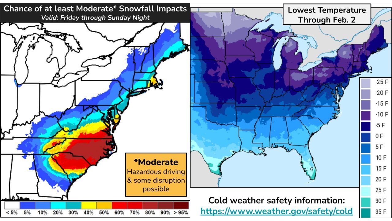
Forecast guidance indicates a growing chance of at least moderate snowfall impacts beginning Friday and continuing through Sunday night. The highest confidence for heavy snow currently spans parts of the Southern Appalachians, the Carolinas, and the southern Mid-Atlantic, where colder air will be firmly in place as the storm intensifies.
While snowfall confidence decreases farther north, forecasters note that southeastern New England may still see accumulating snow depending on the storm’s final track. Snowfall rates could be heavy at times, leading to hazardous travel conditions, reduced visibility, and potential disruptions to daily activity.
Strong Winds, Rough Surf and Coastal Flooding Concerns
In addition to snow, the rapidly deepening storm system is expected to produce widespread strong winds along the East Coast. Where these winds overlap with snowfall, blowing snow and whiteout conditions may develop, especially across exposed areas.
Along the Mid-Atlantic coastline and parts of North Carolina, powerful onshore winds coinciding with astronomically high tides could lead to coastal flooding, beach erosion, and damaging waves. Marine conditions are expected to deteriorate quickly, with rough surf posing risks to coastal infrastructure and navigation.
Forecast Uncertainty Remains With Storm Track
Despite increasing confidence in impactful weather, forecasters caution that uncertainty remains regarding the storm’s exact track and southern extent, particularly on Saturday. Small shifts in storm position could significantly alter snowfall totals and impact zones, especially across the Northeast and coastal areas.
Additional uncertainty exists regarding how the system evolves after passing Cape Hatteras Saturday night, which will determine how far north wintry impacts extend along the East Coast.
Prolonged Extreme Cold Continues Across the Eastern United States
Beyond the storm itself, dangerously cold temperatures are expected to persist across much of the eastern United States into early February. A new Arctic surge is forecast to push south late Thursday, crossing the Midwest and reaching the Gulf Coast by Friday night.
Sub-zero wind chills are expected Friday night across areas already dealing with power outages, while daily record low temperatures are forecast across parts of the Ohio Valley, Mid-Atlantic, and Southeast through the weekend.
Florida Faces Rare and Prolonged Freeze Risk
Forecasters are also highlighting Florida cold concerns, with rare long-duration hard freezes possible along the Gulf Coast and down the Florida Peninsula, especially Saturday and Sunday nights. These conditions pose a serious risk to agriculture, vulnerable populations, pets, and exposed infrastructure.
For some locations, this may represent the longest stretch of extreme cold in several decades, an unusual and impactful scenario for the region.
Why This Weather Pattern Is Especially Concerning
The combination of heavy snow, high winds, coastal flooding threats, and prolonged extreme cold makes this weather pattern particularly dangerous. Impacts may persist long after the storm exits, especially in areas experiencing power outages or infrastructure damage.
Officials stress the importance of early preparation, limiting travel during peak impacts, and closely monitoring updated forecasts as confidence increases and advisories expand.
As the East Coast braces for a potentially significant winter storm and extended Arctic cold, residents are urged to stay informed and prepared for rapidly changing conditions. For continued weather updates, regional impact analysis, and safety information, visit ChicagoMusicGuide.com.