
North Carolina, Virginia and South Carolina Slammed by 70 MPH Wind Gusts as Powerful Cold Front Causes Tree Damage and Power Outages
RALEIGH, NORTH CAROLINA — A powerful cold front sweeping across the Carolinas and parts of Virginia is producing damaging wind gusts between 50 and 70 mph, knocking down trees and triggering power outages as the system moves rapidly east toward the Atlantic coast.
Meteorologists monitoring the storm say the strongest winds are occurring directly along the advancing cold front, where intense downward mixing is pulling stronger winds from higher in the atmosphere down to the surface.
As the line pushes eastward across North Carolina, communities are already reporting numerous fallen trees and scattered power outages.
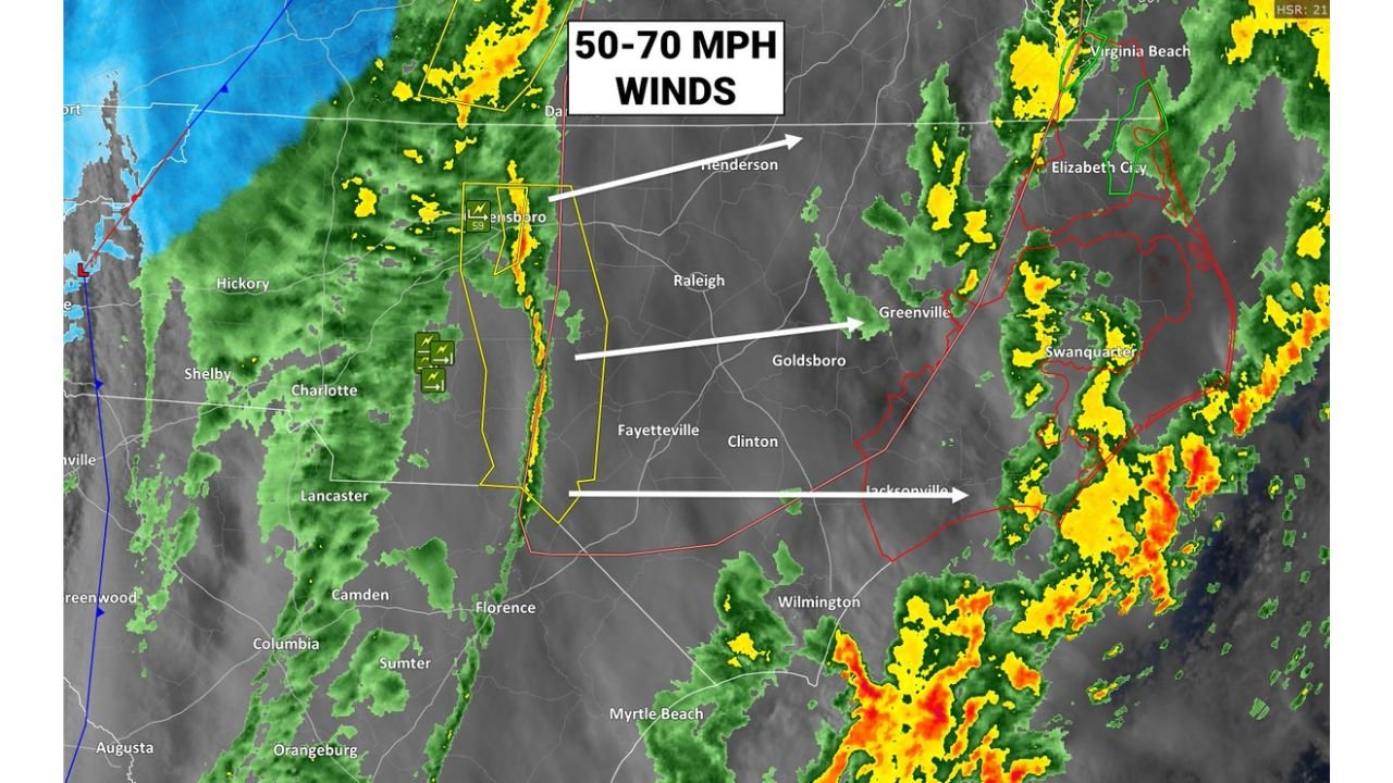
Damaging Wind Line Moving Across North Carolina
Radar imagery shows a narrow but intense band of storms and wind surging east across the state during the late afternoon and evening hours.
Cities currently being impacted or soon in the path of the strongest winds include:
- Greensboro
- Raleigh
- Goldsboro
- Greenville
- Fayetteville
The line is expected to continue racing toward eastern North Carolina and the Outer Banks, where additional strong gusts could impact coastal communities.
Winds Reaching 50–70 MPH Along the Front
Weather analysis indicates the front is capable of producing very strong straight-line winds, with gusts already observed between 50 and 70 mph in some areas.
These winds are strong enough to:
- Snap tree branches
- Uproot weakened trees
- Damage power lines
- Cause scattered structural damage
Meteorologists say the strongest gusts are occurring where stronger winds aloft are being mixed down to the surface, a common feature during fast-moving cold front passages.
Power Outages and Tree Damage Reported
Local emergency management officials say numerous trees have already been reported down across portions of the region as the front continues its eastward march.
Because the storms are moving quickly, the window of intense winds may last only a short time at any single location, but the gusts can still cause widespread disruptions.
Areas west of Interstate 95 have already seen significant impacts, and the line continues pushing toward coastal North Carolina and southeastern Virginia.
Coastal Areas and the Outer Banks Next in Line
The storm system is expected to reach coastal communities and the Outer Banks later this evening, where strong winds could continue as the front moves offshore.
Communities including:
- Elizabeth City
- Virginia Beach
- Jacksonville, NC
- Wilmington
- Outer Banks coastal towns
could experience strong wind bursts as the line of storms approaches the coastline.
Even after the rain moves out, strong winds may continue briefly behind the front.
Why the Winds Are So Intense
The cold front is acting as a boundary between warm, unstable air ahead of the system and cooler air rushing in behind it.
This sharp contrast allows powerful winds from several thousand feet above the ground to rapidly descend during the storm passage, producing sudden bursts of damaging gusts.
These types of wind events often occur without long-lasting thunderstorms, making them particularly dangerous because the strongest winds can arrive quickly.
What Residents Should Expect Tonight
As the system continues moving east, residents across the Carolinas and southeastern Virginia should prepare for:
- Sudden bursts of damaging wind
- Downed tree limbs and debris
- Brief power outages
- Hazardous driving conditions
The strongest winds should gradually weaken once the front moves offshore later tonight.
For continuing coverage of major weather events across the United States, including severe storms and damaging wind events, follow the latest updates on ChicagoMusicGuide.com.