
North Dakota Faces Life-Threatening Wind Chills as Arctic Outbreak Pushes Temperatures Toward 50 Degrees Below Zero
FARGO, NORTH DAKOTA — An exceptionally dangerous surge of Arctic air is forecast to sweep across North Dakota on Saturday, bringing wind chills that may plunge as low as 50 degrees below zero, according to new model guidance released this week. Meteorologists warn that the intensity of the cold could reach levels rarely seen in December, with much of the state expected to experience double-digit subzero temperatures even before wind is factored in.
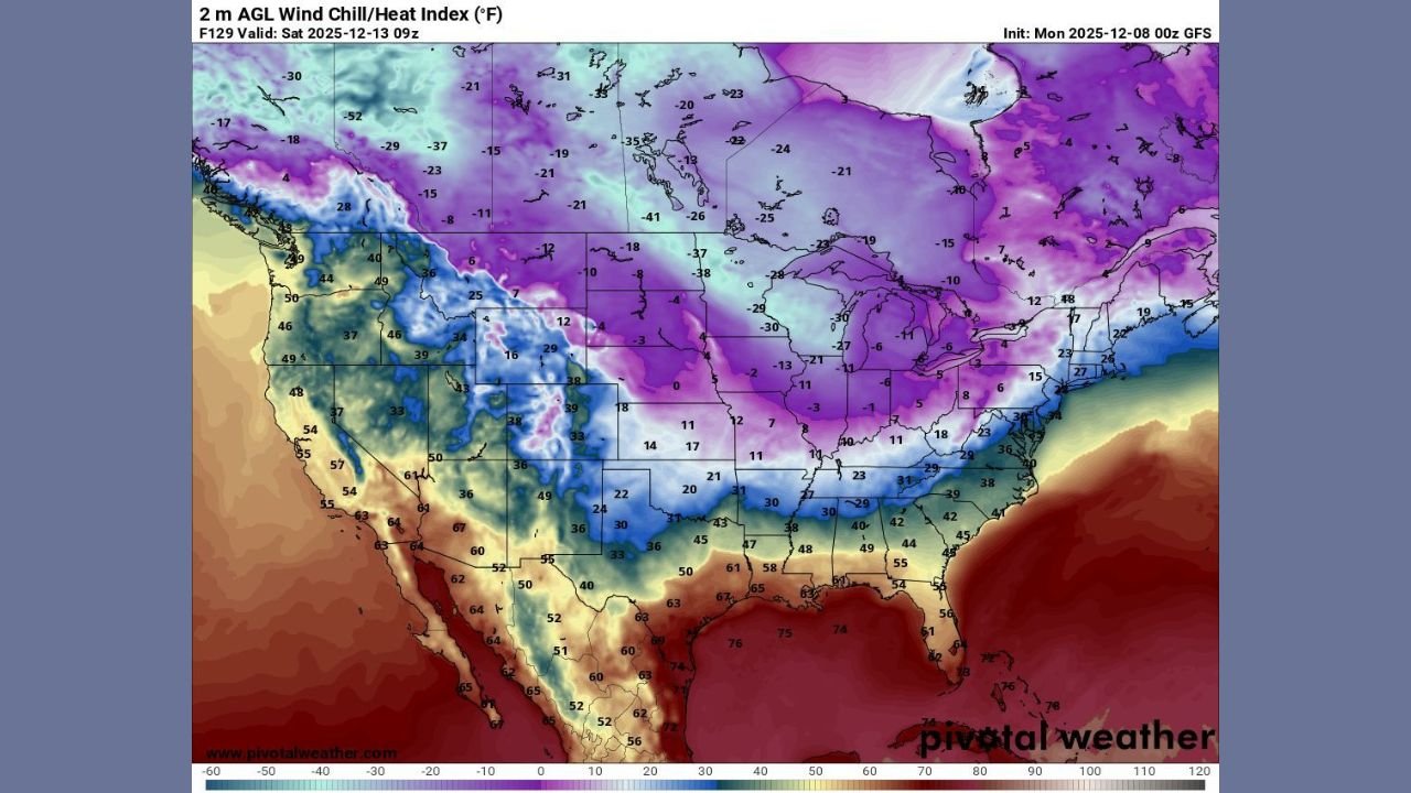
The latest GFS wind-chill projections show a broad area of –30°F to –45°F across northern and central North Dakota, with isolated pockets nearing –50°F, an intensity typically associated with historic Arctic outbreaks. Forecasters emphasize that even short periods of exposure could be dangerous.
A Rare Early-Season Arctic Surge
The incoming cold blast is part of a powerful polar air mass dropping south from Canada and sweeping into the Upper Midwest. On the national maps, nearly the entire northern tier of the United States is covered in deep shades of purple and violet — visual confirmation of how extreme this temperature anomaly is.
In North Dakota, early Saturday morning temperatures are expected to fall between –15°F and –30°F, depending on location. When combined with strong northwest winds, the “feels-like” temperatures could reach the –40°F to –50°F range, conditions that can lead to frostbite in as little as 5–10 minutes.
Meteorologists describe this system as a “classic high-impact Arctic front,” fueled by a strong northern jet stream transporting extremely cold air deep into the Plains.
Why This Cold Is So Extreme
Data from pivotal weather models indicates:
- Wind chills below –40°F are likely across a large portion of the state.
- Wind chills near –50°F are possible in the north and northeast.
- The cold extends beyond North Dakota, impacting Minnesota, Wisconsin, and parts of Montana and South Dakota.
- The temperature anomaly map shows departures of 25–35 degrees below normal, with some areas approaching 50 degrees below typical December averages.
North Dakota’s vast open terrain is expected to worsen the impact, allowing winds to accelerate and push wind chills to dangerous levels.
Travel, Outdoor Activity, and Safety Concerns
Officials in the region are urging residents to prepare now for extremely hazardous conditions. According to forecasters:
- Frostbite can occur rapidly, especially on exposed skin.
- Car batteries may fail, and diesel engines may struggle to start.
- Road conditions may deteriorate due to blowing snow and flash-freezing.
- Vulnerable populations — including the elderly and people experiencing homelessness — face heightened risk.
Residents are advised to limit outdoor exposure, carry emergency winter kits in vehicles, check heating systems, and bring pets indoors.
Upper Midwest Forecast: Coldest Morning of the Season
Saturday morning is expected to be the peak of the Arctic blast. A larger portion of the Midwest will feel the intensity, but North Dakota is positioned in the coldest core of the outbreak, according to current models.
Wind chills will gradually improve into Sunday and Monday, but temperatures are expected to remain well below average for several days.
What’s Next?
Meteorologists continue to track this system closely. While the most severe cold is expected Saturday, additional Arctic surges may follow later in December — a pattern that could lead to prolonged winter hardship across North Dakota and surrounding states.
Residents are urged to stay updated with official forecasts and local emergency alerts.