
North Dakota, Minnesota, Wisconsin, and Illinois Brace for Near-Record Cold as Arctic Blast Drives Dangerous Wind Chills South
CHICAGO, ILLINOIS – A powerful surge of Arctic air is set to spill out of Canada and race across the United States this weekend, bringing near-record cold temperatures and dangerous wind chills from North Dakota and Minnesota through Wisconsin and Illinois, then into the Ohio Valley, Mid-South, and Mid-Atlantic by Sunday and early next week.
According to the Weather Prediction Center’s “Key Messages for Mid-December Extreme Cold”, this blast of frigid air will be one of the harshest of the season so far, with wind chills cold enough to threaten anyone caught outside for long periods—especially during late-night commutes home from shows, rehearsals, or holiday events.
Bitter Cold Expands from the Northern Plains
Forecasters say the Arctic air will plunge southward from the Northern High Plains on Friday, first slamming communities in Montana, the Dakotas, and northern Minnesota with brutally cold wind chills.
By Saturday, the core of the cold will spread into the Central Plains and the Ohio Valley, including Iowa, Missouri, Illinois, Indiana, and Ohio. On Sunday, that same cold pool expands even farther, reaching the Mid-South and Mid-Atlantic, with frigid air pouring into parts of Kentucky, Tennessee, Arkansas, Mississippi, Alabama, Virginia, and the Carolinas.
For Chicago and the rest of northern Illinois, this means a sharp drop from recent temperatures and a stretch of deeply uncomfortable, mid-December cold that will linger into early next week.
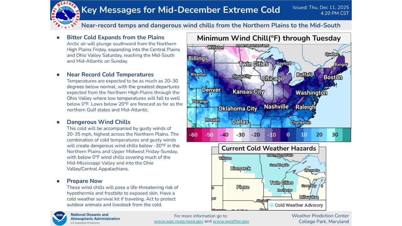
Temperatures 20–30 Degrees Below Normal
The Weather Prediction Center highlights that temperatures in some areas will be 20–30°F below average for mid-December.
- Across the Northern Plains and Upper Midwest, low temperatures are expected to fall well below 0°F, with daytime highs struggling to climb much above that mark.
- Farther south, from the Ohio Valley into the Mid-South and parts of the Deep South, forecast lows are expected to drop below 20°F, a level far colder than typical December nights for many of those communities.
On the WPC map, a broad swath of purple and dark blue shading stretches from Montana and the Dakotas through Minnesota, Wisconsin, and northern Illinois, signaling the coldest wind chills through Tuesday, while lighter blue shades push all the way to Dallas, Nashville, and Raleigh.
For Chicago-area music fans, that means bitter mornings, icy evenings, and very little relief during the middle of the day—conditions that can be dangerous if you’re waiting in line outside a venue or hauling gear between gigs.
Dangerous Wind Chills for the Upper Midwest and Beyond
What makes this event especially serious is not just the low temperatures, but the gusty winds expected to accompany the cold front.
The WPC warns that this outbreak will feature winds of 20–35 mph, especially across the Northern Plains. Combined with the Arctic air, those winds will create dangerous wind chills below –30°F from:
- Northern Plains into the Upper Midwest, including parts of North Dakota, South Dakota, Minnesota, Wisconsin, and northern Iowa.
Farther south, wind chills below 0°F will spread across much of the Mid-Mississippi Valley and into the Ohio Valley and Central Appalachians, reaching cities like Chicago, St. Louis, Indianapolis, Louisville, Cincinnati, and Pittsburgh.
In wind chills this low, exposed skin can begin to freeze in a short period of time, and conditions can quickly turn hazardous, especially late at night after concerts or early in the morning during travel to work or school.
Current Cold Weather Hazards and Advisories
The WPC map already shows Cold Weather Advisories posted across parts of the Northern Plains and Upper Midwest, including North Dakota, South Dakota, and Minnesota, where the first wave of bitter air will arrive.
More advisories and wind chill warnings are likely as the Arctic air dives south and east. Residents in Wisconsin, Illinois, Iowa, Missouri, and the Ohio Valley should stay tuned for additional alerts from their local National Weather Service offices as the weekend approaches.
How Music Fans and Performers Should Prepare
For ChicagoMusicGuide.com readers—whether you’re artists, fans, or venue workers—this outbreak is a reminder to plan around the cold, not after it hits:
- Layer up before heading to shows. Wear thermal base layers, hats, gloves, and warm socks, especially if you’ll be waiting outdoors or riding public transit.
- Limit time outside after dark. Wind chills will be harshest at night and in the early morning hours. Move quickly between car, venue, and home.
- Protect your voice and hands. Singers and instrumentalists should keep scarves, hand warmers, and lip balm handy; extreme cold and dry air can strain vocal cords and stiffen fingers.
- Check on friends, neighbors, and unhoused community members. Extreme cold can be life-threatening, particularly for people without reliable heat or shelter.
- Safeguard pets and gear. Bring pets indoors and avoid leaving instruments or equipment in cold cars, where low temperatures can cause damage.
Looking Ahead
Forecasters caution that while the Arctic blast will ease gradually after early next week, many regions—especially the Upper Midwest and Great Lakes—may stay colder than normal for a time. For now, the immediate message is clear: prepare for one of the harshest stretches of cold so far this season.
ChicagoMusicGuide.com will continue to follow this Arctic outbreak and what it means for live shows, touring bands, and fans across Illinois and neighboring states.
Stay safe, stay warm, and keep an eye on the forecast before you head out to your next concert.