
North Dakota, Minnesota, Wisconsin Face Late-January Arctic Cold as NOAA Warns of Hazardous Sub-Zero Temperatures
NORTH DAKOTA — An extended stretch of dangerous Arctic cold is expected to dominate much of the Midwest and northern Plains during the final week of January, with new federal outlooks showing temperatures plunging far below seasonal norms and raising concerns about prolonged exposure, travel safety, and infrastructure strain.
Latest guidance from the Climate Prediction Center indicates that anomalously cold air will remain locked over the central United States from January 24 through January 30, with the highest risk focused on North Dakota, Minnesota, northern Wisconsin, and parts of the Upper Midwest. In these areas, overnight lows may drop below -20°F, while wind chills could fall even lower during peak Arctic intrusions.
What the Latest Temperature Outlook Shows
New 8–14 day temperature outlook maps highlight a sharp contrast across the country:
- Below-normal temperatures dominate the Midwest and Great Lakes, signaling sustained cold rather than a brief snap
- Northern Plains states sit within the core of the coldest anomalies
- The West Coast trends warmer than average, while the Southeast leans closer to seasonal norms
This pattern reflects a deep, persistent trough in the jet stream, allowing polar air to spill south repeatedly instead of retreating after a single cold wave.
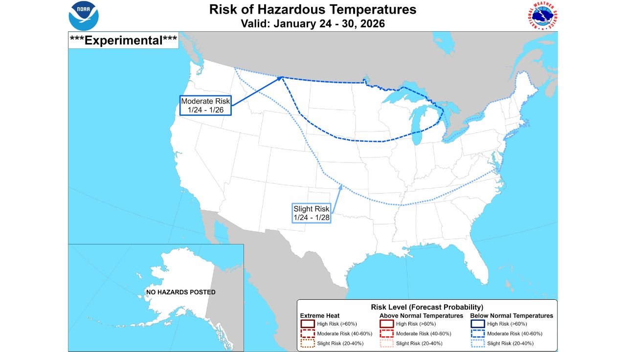
Hazardous Cold Risk Areas Identified
The CPC’s experimental Risk of Hazardous Temperatures outlook places parts of the northern U.S. under elevated concern:
- Moderate Risk (Jan. 24–26): Northern Plains into the Upper Midwest
- Slight Risk (Jan. 24–28): Expanding south and east into portions of the central Plains and Upper Midwest
Forecasters stress that while exact temperature values can still fluctuate, confidence is growing that this will be a prolonged cold period, not just an overnight dip.
Why This Cold Spell Matters
Extended Arctic outbreaks pose challenges beyond uncomfortable conditions:
- Health risks increase due to frostbite and hypothermia potential
- Energy demand spikes, increasing strain on power and heating systems
- Travel disruptions become more likely as vehicles struggle in extreme cold
- Outdoor events and late-January travel plans may need adjustments
Even areas accustomed to winter cold can feel impacts when below-normal temperatures persist for several days in a row.
What to Expect Next
Forecasters will continue refining details over the coming days, but the overall signal remains consistent: late January is shaping up to be one of the coldest stretches of the season for the Midwest. Any short-lived warmups are expected to be brief before colder air re-establishes itself.
Residents across the region are encouraged to monitor local forecasts, prepare vehicles and homes for extreme cold, and plan ahead for potential disruptions as the Arctic pattern holds firm.
For more weather outlooks, national forecasts, and how changing conditions could impact travel and events, stay connected with ChicagoMusicGuide.com and check back as this developing cold surge continues to evolve.