
North Texas, Oklahoma and Southeast Kansas Highlighted for Significant Tornado Potential Friday as GFS CWASP Values Surge Above 80%
UNITED STATES — A potentially significant severe weather setup is taking shape for Friday, with forecast guidance flagging North Texas, central and eastern Oklahoma, and southeast Kansas as the corridor to watch.
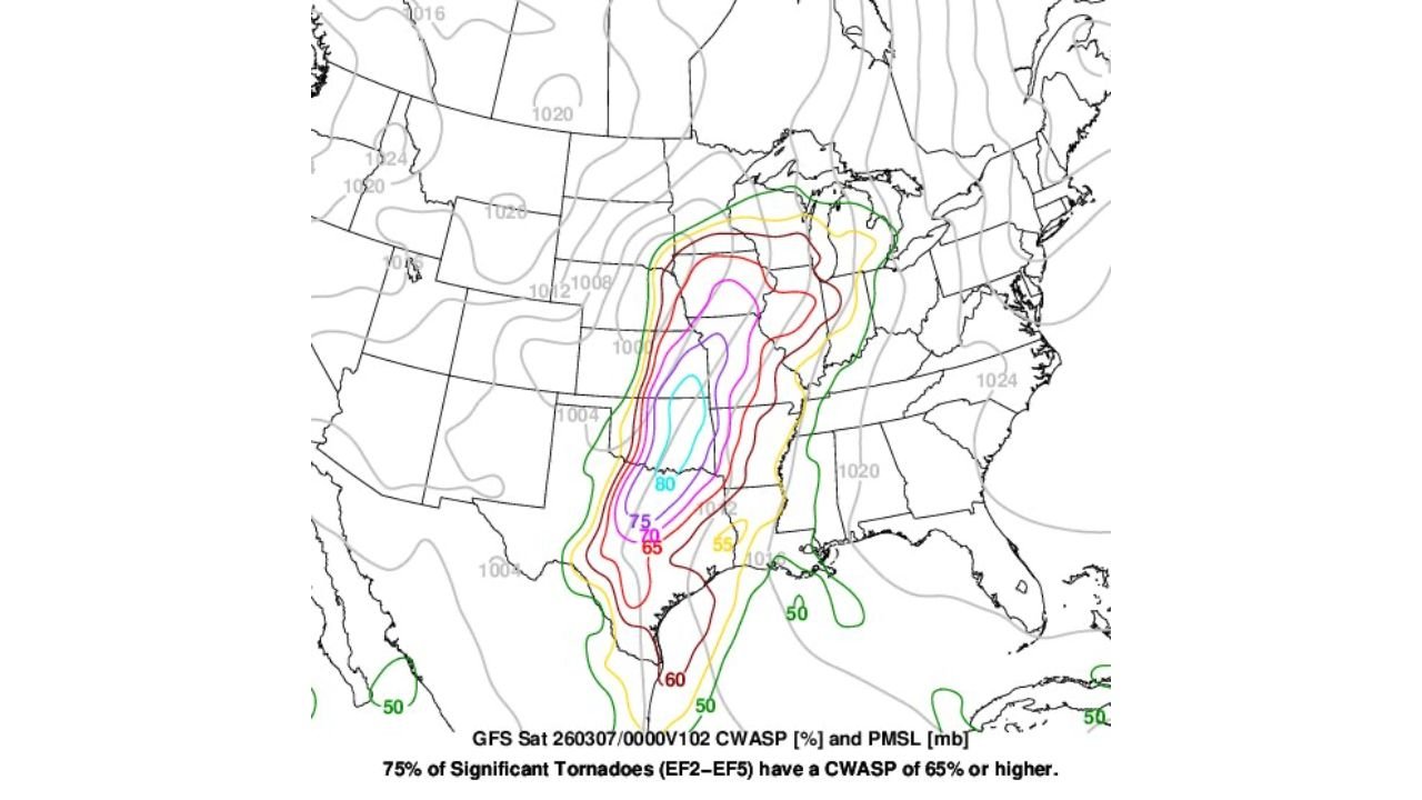
The GFS model’s CWASP (Conditional Weighted Analog Significant Parameter) output is showing values exceeding 80% across parts of this region — a signal that has historically been strongly correlated with significant severe storms, including strong tornadoes.
What the 80%+ CWASP Signal Means
CWASP is a composite parameter designed to identify environments supportive of significant severe weather. According to the data displayed:
- 75% of significant tornadoes (EF2–EF5) have a CWASP of 65% or higher.
- Forecast values are reaching 70%, 75%, and even 80%+ across portions of North Texas and Oklahoma.
The highest values appear centered over:
- Dallas–Fort Worth and North Texas
- Southern and central Oklahoma
- Extending northward into southeast Kansas
These numbers suggest the atmospheric setup could support organized, potentially high-end severe storms if other ingredients align.
Core Risk Corridor: Dallas to Oklahoma City to Wichita
The most concentrated area of elevated CWASP values stretches from:
- Dallas and surrounding North Texas communities
- North through Ardmore, Norman and Oklahoma City
- Into Wichita and southeast Kansas
Within this corridor, 70–80%+ contours overlap with favorable pressure patterns, indicating a potentially dynamic upper-level system interacting with returning Gulf moisture.
Strong Correlation With Significant Severe
CWASP values above 65% have historically aligned with environments capable of producing:
- Strong tornadoes (EF2 or higher)
- Long-lived supercells
- Large hail
- Damaging wind events
With some areas exceeding 80%, this suggests that if storm initiation and timing align properly, the setup could be supportive of significant impacts.
However, the exact magnitude of the event will depend on:
- Upper-level pattern evolution
- Storm mode (discrete supercells vs. clusters)
- Moisture quality and instability
- Timing of forcing mechanisms
Upper-Level Pattern Key to Friday’s Outcome
The forecast discussion notes that the severe threat depends heavily on how the upper-level pattern holds as it approaches. A well-timed trough and jet streak would enhance wind shear and lift — critical ingredients for rotating storms.
If the pattern remains strong and organized:
- Discrete supercells could develop along the dryline or frontal boundary
- Tornado potential would increase within the highest CWASP zones
If the system becomes more linear or moisture return is delayed, the severe threat could shift in character.
Implications for the Midwest
While the primary focus appears to be over Texas, Oklahoma and southeast Kansas, systems that originate in this corridor often track northeast toward:
- Missouri
- Arkansas
- The lower Midwest
Residents downstream should monitor forecast updates as the event draws closer.
Bottom Line
Friday’s setup is being flagged by the GFS model with 80%+ CWASP values across North Texas, Oklahoma and southeast Kansas — a statistically significant signal associated with higher-end severe weather potential.
While details will refine in the coming days, this is a corridor that deserves close attention as we move deeper into early spring severe weather season.
ChicagoMusicGuide.com will continue tracking forecast updates and any official outlook changes as Friday approaches.