
Northeast and New England Brace for “Grinch Storm” Bringing Heavy Rain and Strong Winds Before Christmas
NORTHEASTERN UNITED STATES — A fast-moving storm system known to many forecasters as the “Grinch Storm” is expected to sweep across large portions of the Northeast and New England between Thursday night and Friday, delivering a round of heavy rain, strong winds, and fast-changing temperatures just days before Christmas. The disturbance, which consistently appears around this time of year, will push warm air, widespread rainfall, and gusty winds across several states before colder conditions return Friday evening.
Widespread Rainfall Expected Thursday Night Into Friday
Current model guidance suggests that the storm will bring 1.0 to 1.5 inches of rain to much of the region, with the heaviest amounts occurring from 10 PM Thursday through 10 AM Friday. Forecast maps show a concentrated band of moderate to heavy precipitation stretching across Pennsylvania, New York, Connecticut, Massachusetts, Vermont, New Hampshire, Rhode Island, and Maine, signaling a messy morning commute for millions.
Although rainfall totals are not expected to reach flooding criteria for most areas, forecasters note that brief urban ponding, reduced visibility, and travel delays are possible during the peak of the event.
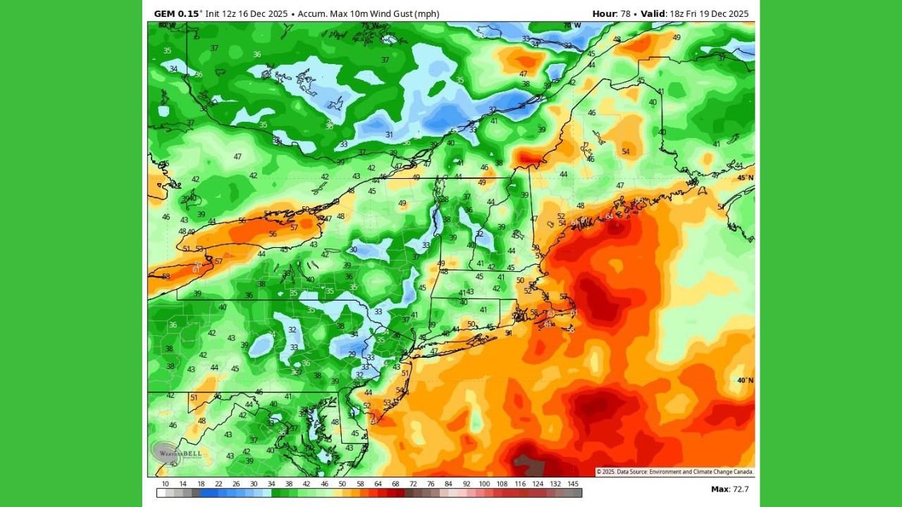
Strong Southern Winds May Cause Minor Power Issues
One of the storm’s most notable features will be its 35–45 mph wind gusts arriving from the south late Thursday night into Friday midday. These winds may be strong enough to cause isolated tree branches down and scattered power interruptions, though meteorologists caution that extreme wind gusts depicted in some model runs are likely exaggerated.
Even after the rain clears, winds are expected to surge again from the west late Friday afternoon into Friday evening. These secondary gusts, likely exceeding 40 mph at times, may create additional weather impacts as colder air pours back into the region behind the storm.
A Busy Week of Weather Across the Northeast
The upcoming Grinch Storm follows a week of sharp temperature swings, accumulating snow in parts of the Mid-Atlantic and New England, and bitter cold behind earlier systems. With a fresh surge of warm air, heavy rain, and powerful winds, this next event continues what has already been a highly dynamic December weather pattern.
Communities from Maryland to Maine should monitor updated forecasts as the system approaches, particularly travelers preparing for pre-holiday plans.
What Residents Should Know
- Rainfall: 1.0–1.5 inches, mainly overnight Thursday into Friday morning
- Primary winds: 35–45 mph from the south Thursday night into Friday
- Secondary winds: 40+ mph from the west Friday afternoon and evening
- Possible impacts: wet roads, spotty tree damage, minor power disruptions, reduced visibility for commuters
Forecasters emphasize there is no major cause for alarm, but acknowledge that the combination of timing, rainfall, and wind could create a hectic period for residents across the Northeast and New England.
Stay Connected
For continuing weather updates, breaking storm coverage, and community alerts, keep following ChicagoMusicGuide.com.