
Northeast Temperatures Collapse After Sunset as Single-Digit Readings and Teens Dominate From New England to the Mid-Atlantic
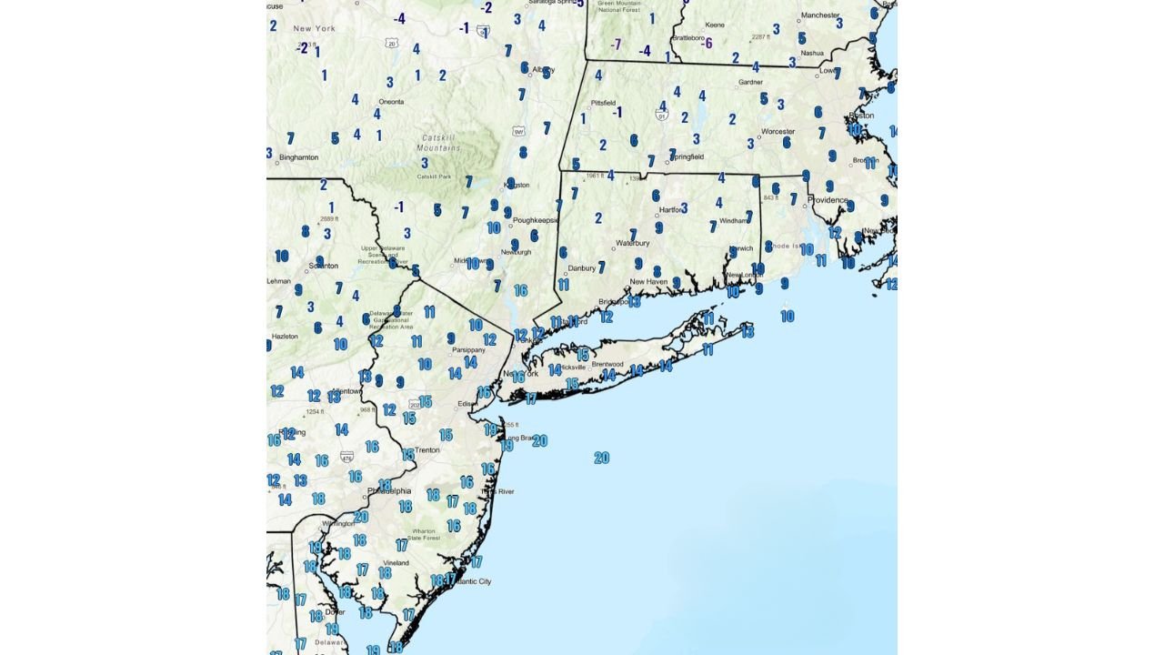
UNITED STATES — A sharp and widespread temperature collapse unfolded across the Northeast and Mid-Atlantic Saturday evening, as Arctic air surged into the region and drove readings into the single digits and teens by 10 PM. NOAA temperature data shows the cold settling in rapidly from upstate New York and New England southward into New Jersey, eastern Pennsylvania, and coastal New England, marking one of the coldest evenings of the season so far.
Meteorologists described the evening setup as a “tank job,” with temperatures falling quickly after sunset and leaving little time for surfaces, infrastructure, or people to adjust.
Single-Digit Cold Expands Across Interior New England and Upstate New York
The coldest readings were concentrated across interior New York, Vermont, New Hampshire, and western Massachusetts, where many locations fell into the single digits, with a few spots dipping to near or below zero.
Temperatures around Albany, the Catskills, central Vermont, and interior New Hampshire hovered in the 1° to 7°F range, signaling a deeply entrenched Arctic air mass. These values reflect not just overnight cooling, but a broader cold pattern firmly established across the region.
Teens Hold Along the I-95 Corridor — But Still Well Below Normal
Even traditionally milder coastal and urban areas were unable to escape the cold. By 10 PM, much of the I-95 corridor, including New York City, Long Island, coastal Connecticut, Rhode Island, and eastern Massachusetts, reported temperatures in the low to mid-teens.
Farther south, New Jersey, eastern Pennsylvania, Delaware, and coastal Maryland remained mostly in the upper teens, but forecasters noted that these readings were still well below late-January averages, especially considering the relatively early evening timing.
Why This Cold Drop Stands Out
What makes this event notable is not just how cold it became, but how fast temperatures fell. The combination of:
- Clear to partly clear skies
- Dry Arctic air
- Light winds inland allowing radiational cooling
- A fresh Arctic air mass already in place
allowed temperatures to nosedive quickly after sunset. Many locations dropped 10 degrees or more in just a few hours, catching some residents off guard.
Wind Chills and Exposure Concerns Increase Overnight
While winds were not extreme everywhere, even light breezes combined with these temperatures pushed wind chill values into the single digits or near zero in parts of New England and upstate New York.
Cold like this increases the risk of:
- Frostbite with prolonged exposure
- Hypothermia, especially for those without adequate shelter
- Frozen pipes in poorly insulated structures
Officials continue urging residents to limit time outdoors overnight, dress in layers, and ensure pets and vulnerable populations are protected.
What to Expect Through the Night and Into Sunday
Temperatures are expected to remain very cold through the overnight hours, with some inland locations likely bottoming out near their evening readings or falling a few degrees further before daybreak. While gradual moderation is expected later Sunday, cold conditions will persist across much of the Northeast into the start of the new week.
As this Arctic air mass tightens its grip on the region, the abrupt evening temperature collapse serves as a reminder of how quickly winter conditions can turn dangerous. For continued coverage of cold outbreaks, winter weather impacts, and regional forecasts across the United States, visit ChicagoMusicGuide.com.