
Northeast Winter Storm Targets Pennsylvania, Maryland, New Jersey, and New York With Snow, Sleet, and Dangerous Ice After Christmas
PENNSYLVANIA, MARYLAND, NEW JERSEY, AND NEW YORK — A complex winter storm system is expected to move across the Northeastern United States just after Christmas, bringing a dangerous mix of snow, sleet, and freezing rain that could significantly disrupt travel and daily activities from Friday into Saturday. Forecast data indicates that central Pennsylvania, Maryland, southern New Jersey, and parts of Delaware are most at risk for damaging ice accumulation, while interior New York and northern New England could see several inches of snow.
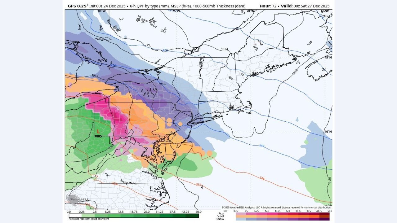
Snowfall Outlook Across the Northeast
Forecast models show a broad swath of accumulating snow stretching from upstate New York through portions of New England, where cold air remains firmly in place. Areas including Binghamton, Albany, Syracuse, and interior sections of Vermont and New Hampshire are positioned within the zone of steady snowfall, with some locations potentially seeing six inches or more if heavier snow bands stall.
Meteorologists note that snowfall rates could briefly exceed one inch per hour within narrow but intense bands. The exact placement of these bands remains uncertain, but the overall setup favors widespread plowable snow in northern zones. As the system progresses eastward, snow is expected to continue into parts of Massachusetts and Connecticut, though coastal areas may see more mixing.
Ice and Sleet Threat in Pennsylvania, Maryland, and New Jersey
The most significant hazard from this storm may come from freezing rain and sleet, particularly across central Pennsylvania, northern Maryland, southern New Jersey, and northern Delaware. Forecast guidance suggests that warm air aloft will override sub-freezing surface temperatures, creating ideal conditions for ice accretion.
In parts of central Pennsylvania, ice accumulations could reach three-tenths of an inch or more, which is enough to cause power outages, downed tree limbs, and extremely hazardous road conditions. Areas near Harrisburg, State College, and surrounding communities appear especially vulnerable. Sleet is also expected to dominate for a time, further complicating travel and cleanup efforts.
Changing Conditions and Timing Concerns
One of the key challenges with this storm is its complex evolution. Precipitation types may change rapidly over short distances, meaning some communities could transition from snow to sleet to freezing rain within a few hours. Coastal sections of New Jersey and southeastern Pennsylvania may eventually change to plain rain toward the end of the event, but not before dangerous icing occurs inland.
The storm is expected to begin impacting the region late Friday, intensify overnight, and continue into Saturday morning. Forecasters caution that minor shifts in storm track or temperature profiles could significantly alter who sees the worst impacts.
Travel Disruptions and Safety Concerns
With holiday travel still underway, officials are urging residents to prepare for rapidly deteriorating road conditions. Ice-covered roads, reduced visibility during heavy snow, and potential power disruptions could make travel dangerous or impossible in some areas. Airports across the Northeast may also experience delays or cancellations, particularly where freezing rain is involved.
Emergency managers advise keeping extra supplies, charging electronic devices in advance, and avoiding unnecessary travel during the height of the storm. Conditions may remain hazardous even after precipitation ends due to lingering ice and untreated roadways.
As this post-Christmas winter storm unfolds, residents across the Northeast should closely monitor local forecasts and be prepared to adjust plans as conditions evolve. For continued weather updates, regional impact breakdowns, and storm coverage, stay connected with ChicagoMusicGuide.com, where we track major weather events affecting communities nationwide.