
Northern Illinois and Indiana Under Significant Tornado Risk Tuesday as Warm Front Ignites Intense Supercells; Southern Plains Face All-Hazards Threat
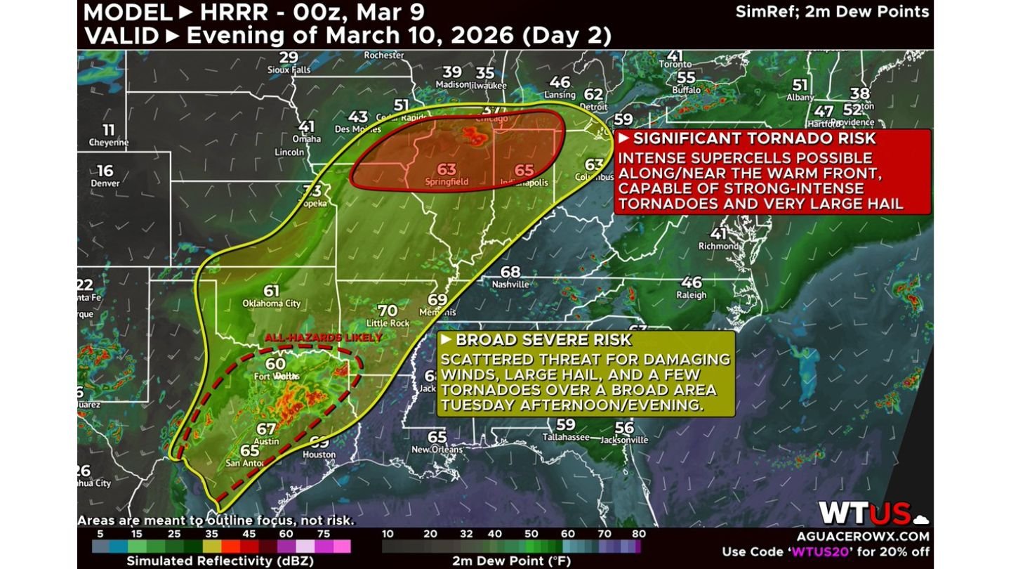
CHICAGO, ILLINOIS — A broad but potentially dangerous severe weather setup is expected to unfold Tuesday afternoon and evening, with a focused significant tornado risk across northern Illinois, northern Indiana, and northeast Missouri, while a separate all-hazards severe zone stretches into Oklahoma and Texas. Forecast guidance highlights two distinct areas where storms could intensify rapidly, especially along a warm front draped across the Midwest.
Forecasters emphasize that while severe storms will be scattered across a large portion of the central United States, the most dangerous conditions appear concentrated near the warm front in Illinois and Indiana, where strong-intense tornadoes are possible.
Warm Front Across Northern Illinois Signals Tornado Concern
A strengthening warm front extending from northeast Missouri through northern Illinois into northern Indiana is expected to become the focal point for severe storm development late Tuesday. Dew points are forecast to pool into the lower to mid-60s across central and northern Illinois, creating a moisture-rich environment supportive of rotating storms.
Model guidance indicates that intense supercells may develop along or just north of the warm front, where wind shear is maximized. These storms would have the potential to produce:
- Strong to intense tornadoes
- Very large hail
- Localized damaging wind gusts
The highlighted corridor includes areas near Springfield, Illinois, Peoria, Rockford, and toward northern Indiana, placing a significant portion of northern Illinois in the zone of concern.
Meteorologists note that small-scale details, such as the exact placement of the warm front and storm initiation timing, will determine where the highest tornado threat ultimately sets up.
Evening Storm Development Likely Across Illinois and Indiana
Storms are expected to intensify during the late afternoon and evening hours, a period when atmospheric instability and wind energy peak. If supercells remain discrete before merging into larger clusters, the tornado threat could be enhanced.
Northern and central portions of Illinois appear especially vulnerable if storms become surface-based near the boundary. The combination of moisture, instability, and strengthening wind fields is consistent with past early-spring severe weather events across the Midwest.
Even outside the highest-risk tornado zone, large hail — potentially significant in size — may occur with the strongest supercells across Illinois and Indiana.
Broad Severe Risk Extends into the Southern Plains
While the Midwest faces a localized tornado concern, a broader severe weather area stretches from Oklahoma into central and eastern Texas. In this region, damaging winds and large hail are expected to be the dominant hazards.
Areas near Fort Worth, Austin, and San Antonio are positioned within a corridor where robust storms could develop during the afternoon. Though tornado potential appears somewhat lower than in Illinois and Indiana, a few tornadoes — including potentially stronger EF2+ tornadoes — cannot be ruled out if surface-based supercells form.
This southern branch of the system represents an all-hazards severe setup, with storms capable of producing:
- Large hail, especially in stronger updrafts
- Damaging wind gusts
- Isolated tornadoes
The overlap of strong instability and wind shear across Texas increases the risk for organized thunderstorm clusters.
Midwest Setup More Localized but Potentially Dangerous
Across the Midwest, the severe weather risk is more localized but may be more intense where storms align with the warm front. The presence of dew points in the 60s this far north in early March underscores the unusual nature of this setup.
If supercells develop cleanly along the boundary, Illinois and northern Indiana could experience a few strong tornadoes during the evening hours, making preparedness critical.
Residents across Chicago, Peoria, Springfield, and surrounding communities should closely monitor forecast updates as small shifts in the warm front position could change the exact area of greatest impact.
Preparedness Urged Ahead of Late-Day Storms
Because severe weather is expected during the late afternoon and evening, many residents across Illinois, Indiana, Missouri, Oklahoma, and Texas may be commuting or attending evening events when storms begin to intensify.
Emergency officials recommend:
- Ensuring weather alerts are enabled on mobile devices
- Identifying safe shelter locations in advance
- Monitoring local radar and forecast updates
As this widespread severe weather setup approaches, meteorologists will refine the forecast to determine where the most significant tornado risk ultimately materializes.
For continuing updates on Illinois severe weather, Midwest tornado risk, and Southern Plains storm developments, visit ChicagoMusicGuide.com for comprehensive and timely weather coverage.