
Northern Illinois Severe Weather Threat Tuesday as Supercells May Develop Near Chicago Rockford and Peoria
CHICAGO, ILLINOIS — Forecast models are beginning to highlight a potential severe weather setup across northern Illinois on Tuesday, with meteorologists watching closely for supercell thunderstorms that could develop along a warm front stretching across the region. New model guidance suggests storms may organize within the warm sector of the system, increasing the possibility of rotating thunderstorms capable of producing tornadoes, large hail, and damaging winds.
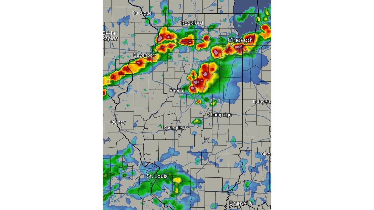
The latest model projections show storm development extending from eastern Iowa through northern Illinois and toward the Chicago metro area, with some of the strongest storms appearing near Rockford, Chicago, Peoria, and Davenport during the peak period of instability.
Forecast Models Indicate Supercells May Form Across Northern Illinois
Meteorologists say the RFS model is now within forecasting range for Tuesday’s weather system, and early signals indicate that discrete supercell storms could develop along the warm front positioned across northern Illinois.
If storms remain separated rather than forming into a solid line, the environment may support rotating supercells capable of producing severe weather hazards. The radar projection imagery shows multiple clusters of storms forming across northern Illinois counties between Rockford and Chicago, with additional storms developing farther southwest toward Peoria and central Illinois.
These storms would likely move east or northeast across the region, potentially impacting communities along the Interstate 88 and Interstate 90 corridors.
Tornado Potential Depends on Storm Interaction with Warm Front
Meteorologists note that the largest tornado threat would occur if thunderstorms interact with the warm front boundary across northern Illinois.
Warm fronts often provide strong wind shear and low-level rotation, two key ingredients needed for tornado formation. If storms track directly along this boundary, they may become rotating supercells capable of producing tornadoes, particularly during the late afternoon or evening hours.
Cities including Chicago, Rockford, Aurora, and nearby suburbs could fall within the corridor where storms may intensify if the boundary sets up in the right location.
However, forecasters emphasize that the exact placement of the warm front and storm development remains uncertain, which will determine where the highest severe weather risk ultimately occurs.
Large Hail and Damaging Winds Also Possible
In addition to the tornado risk, meteorologists warn that large hail and strong damaging winds could accompany the most intense storms across northern Illinois.
Supercell thunderstorms often produce hail larger than one inch in diameter, along with wind gusts capable of damaging trees, power lines, and structures. The radar simulation imagery suggests that several intense storm cores may develop across northern Illinois counties, indicating strong updrafts capable of producing severe weather.
Areas farther south toward central Illinois and the St. Louis region may also see thunderstorms, though the most organized storms appear likely to develop farther north.
Forecasters Continue Monitoring Model Trends
While early signals show a potentially volatile storm environment across northern Illinois, meteorologists stress that forecast confidence will improve as newer model runs refine the exact storm track and timing.
Weather conditions across the Midwest can change rapidly, especially when warm fronts and supercell development are involved, meaning the final storm corridor could shift north or south in the coming days.
Residents across Chicago, Rockford, Peoria, and surrounding northern Illinois communities are encouraged to stay alert for updated forecasts as meteorologists continue tracking the evolving weather pattern.
For continuing coverage of developing storms, severe weather outlooks, and forecast updates across the Midwest, visit ChicagoMusicGuide.com, where meteorologists provide the latest insights on weather conditions affecting Illinois and neighboring states.