
Northern Mississippi and Alabama Under Upgraded Tornado Risk as SPC Highlights 5% Probability Zone from Greenwood to Tupelo Monday Evening
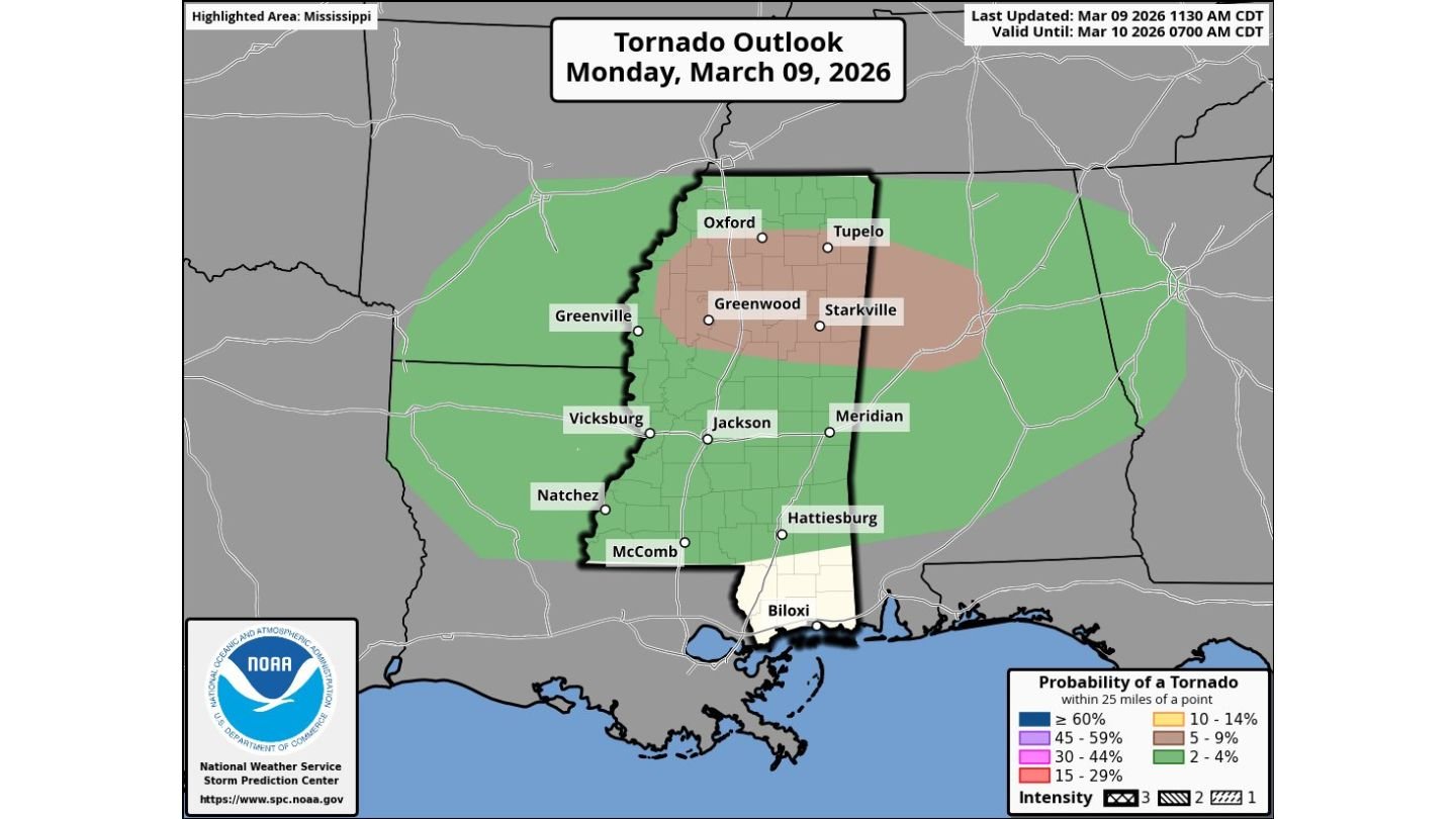
JACKSON, MISSISSIPPI — The Storm Prediction Center has upgraded tornado probabilities to 5% across northern Mississippi and northern Alabama for Monday afternoon and evening, placing cities such as Greenwood, Starkville, Tupelo, and parts of northwest Alabama within a focused tornado outlook zone. While large hail and damaging winds remain the primary threats, forecasters say a few tornadoes are possible, particularly where storms interact with local boundaries.
The updated outlook remains valid through early Tuesday morning, with severe weather expected to intensify during the late afternoon and evening hours.
Tornado Outlook Focused on Northern Mississippi
The highlighted tornado corridor stretches across north-central Mississippi, including:
- Greenwood
- Starkville
- Oxford
- Tupelo
This zone reflects the area where atmospheric conditions — including increasing low-level wind shear — could support isolated tornadic supercells. The 5% tornado probability means a tornado could occur within 25 miles of any given point in the highlighted area.
Forecasters note that a modest increase in low-level shear during the afternoon and evening, combined with the possibility of an outflow boundary from earlier storms, may enhance the tornado threat locally.
However, tornado development is expected to be isolated rather than widespread.
Large to Very Large Hail and Damaging Winds Main Concerns
Despite the tornado upgrade, meteorologists emphasize that large to very large hail and damaging wind gusts will likely be the dominant hazards across Mississippi and Alabama.
Storms forming within the instability corridor could produce:
- Large hail capable of damaging vehicles and roofs
- Strong wind gusts capable of downing trees and power lines
- Brief heavy rainfall
Cities such as Jackson, Meridian, Vicksburg, Greenville, and Hattiesburg fall within the broader severe weather risk area, though the tornado focus remains farther north.
Northern Alabama Also in the Risk Zone
The eastern extension of the outlook includes parts of northern Alabama, where similar atmospheric conditions may allow storms to maintain strength as they track eastward.
As storms move from northern Mississippi into northwest Alabama, the risk of hail and damaging winds will continue into the evening hours.
Forecasters caution that even storms not producing tornadoes could still cause significant impacts due to hail size and wind intensity.
Timing: Afternoon Through Late Evening
The most active period is expected during the afternoon and evening hours, as low-level wind fields strengthen and interact with daytime heating.
If supercells become established near the outflow boundary or within the enhanced shear zone, a few tornadoes could occur before storms weaken overnight.
However, the outlook suggests the event will be characterized more by severe hail and wind rather than a widespread tornado outbreak.
Residents Urged to Stay Alert
With the tornado probability upgraded and multiple severe hazards possible, residents across northern Mississippi and northern Alabama are encouraged to:
- Monitor local weather alerts
- Have multiple ways to receive warnings
- Review severe weather safety plans
Even with a relatively modest tornado probability, isolated supercells can produce significant impacts if they interact with favorable wind patterns.
As conditions evolve through Monday evening, meteorologists will continue tracking storm development across Mississippi and Alabama.
For ongoing updates on Southern severe weather, tornado outlooks, and regional storm developments, visit ChicagoMusicGuide.com for comprehensive coverage.