
Northwest Illinois to Northern Indiana Under Significant Tornado Risk Tuesday as Warm Front Targets Rockford, Chicago, and Gary Through Midnight
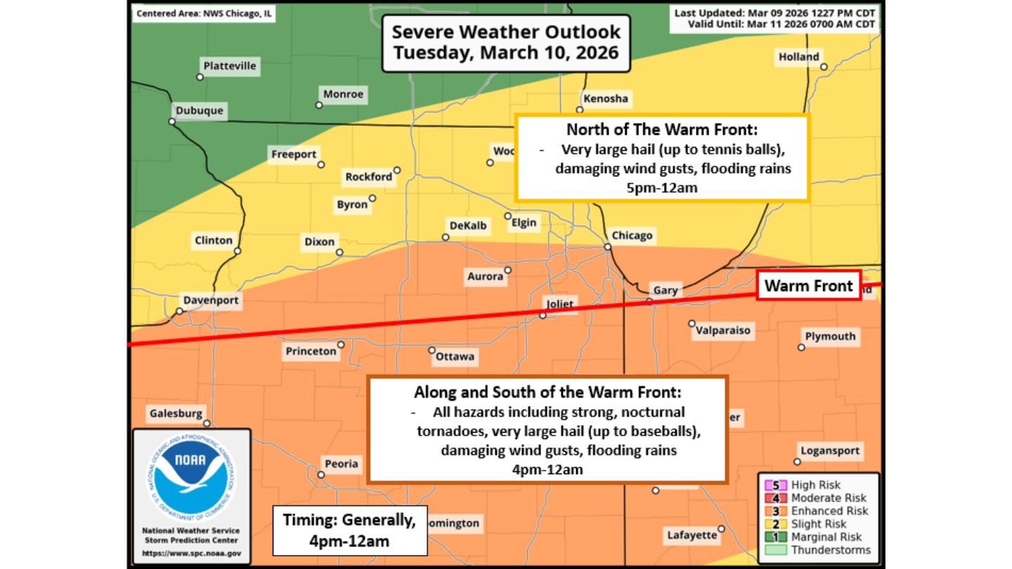
ILLINOIS — The latest severe weather outlook valid Tuesday, March 10, 2026, places northwest and north-central Illinois in a focused corridor for potentially dangerous storms developing between 4 p.m. and midnight. The greatest concern centers along and south of a warm front draped across northern Illinois into northern Indiana, where forecasters indicate all hazards — including strong tornadoes — are possible.
Storms are expected to initiate across northwest Illinois during the late afternoon, then shift east into northern Indiana and southwest Michigan after 7–8 p.m., maintaining a continued severe threat into the night.
Significant Tornado Risk Along the Warm Front
The most serious concern lies along and just south of the warm front, which stretches from northwest Illinois through the Chicago metro and into Gary, Indiana. In this zone, atmospheric conditions support intense supercells capable of strong to potentially intense tornadoes.
Cities within or near this higher-risk corridor include:
- Rockford
- Chicago
- Joliet
- Aurora
- Gary, Indiana
Forecasters highlight that storms forming along or near this boundary could produce:
- Strong tornadoes, including possible nocturnal tornadoes
- Very large hail (up to baseball size)
- Damaging wind gusts
- Flooding rainfall
The tornado risk is expected to peak during the late afternoon and early evening, though some storms may persist or even intensify after sunset.
North of the Warm Front: Tennis-Ball Hail and Damaging Winds
Communities north of the boundary — including Freeport, DeKalb, Elgin, and areas closer to the Wisconsin state line — remain under a severe threat, but with a slightly different hazard emphasis.
In this northern zone, primary threats include:
- Very large hail, potentially up to tennis-ball size
- Damaging wind gusts
- Flooding rains between 5 p.m. and midnight
While tornado potential appears lower north of the front, intense hail-producing supercells remain likely if storms develop in this cooler, sheared environment.
Storm Evolution: West to East Shift
Forecast timing suggests storms will begin across northwest Illinois in the mid-to-late afternoon, including areas near Dixon, the Quad Cities, and Rockford. As the evening progresses, the severe weather threat will move east into:
- Chicago metro
- Northwest Indiana
- Southwest Michigan
The most active window remains 4 p.m. through 12 a.m., with continued severe potential after 7–8 p.m. as storms track eastward.
This means the Chicago evening commute and nighttime hours could coincide with peak storm intensity.
Lake Breeze Could Shift the Boundary
One key uncertainty involves a potential Lake Michigan lake breeze boundary that could develop midday or early afternoon. If this boundary pushes the warm front south — especially across the southern Chicago suburbs and northern Indiana — it may shift the zone of highest tornado risk.
A southward shift of the warm front would:
- Reduce tornado potential north of the boundary
- Increase emphasis on hail and damaging winds instead
However, if the warm front remains in place across north-central Illinois, the tornado risk would stay elevated in and around the Chicago metro region.
All Hazards Possible Through Midnight
The updated outlook clearly outlines an all-hazards severe weather setup across northern Illinois and into northern Indiana. Impacts may include:
- Strong tornadoes (along/south of the warm front)
- Very large hail
- Damaging winds
- Flooding rainfall
Given the evening timing, residents across Illinois and northern Indiana should ensure they have multiple ways to receive weather alerts and review safe shelter plans ahead of storm development.
As the warm front placement becomes clearer Tuesday afternoon, the exact corridor of highest tornado risk will sharpen.
For ongoing updates on Illinois severe weather, tornado watches, and storm timing across Chicago and surrounding communities, visit ChicagoMusicGuide.com for the latest forecast developments.