
Ohio and Pennsylvania Face Isolated Significant Tornado Threat Today Across Eastern Ohio and Western Pennsylvania Including Pittsburgh
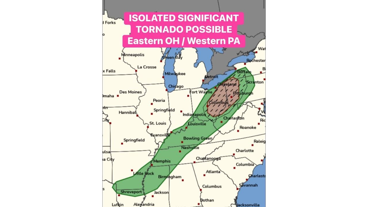
PITTSBURGH, PENNSYLVANIA — A developing severe weather setup today is raising concern for an isolated significant tornado across eastern Ohio and western Pennsylvania, particularly during the afternoon hours as storms strengthen in the region. Forecast guidance highlights this corridor as the only part of the broader warm sector with sufficient low-level wind shear to support a stronger tornado threat.
The potential storm corridor extends across eastern Ohio into western Pennsylvania, including major population centers such as Columbus, Cleveland, Akron, Youngstown, and Pittsburgh, where atmospheric conditions may allow rotating supercell thunderstorms to develop.
Eastern Ohio and Western Pennsylvania Identified as the Primary Tornado Risk Area
Weather outlook maps show the highest tornado potential focused between Columbus, Cleveland, and Pittsburgh, where instability and wind shear overlap during the afternoon period.
This corridor stands out compared with surrounding areas because the combination of warm air, moisture, and stronger low-level winds creates a more favorable environment for rotating storms. If thunderstorms form within this zone and remain organized, they could evolve into supercells capable of producing tornadoes.
Communities across eastern Ohio and western Pennsylvania, especially near Cleveland, Akron, Youngstown, and the Pittsburgh metro area, may experience the strongest storms if development occurs along this corridor.
Warm Sector Environment Could Support Rotating Supercell Storms
The developing severe weather threat is tied to the warm sector of a larger storm system spreading across the central and eastern United States. Warm, humid air flowing northward into the Ohio Valley is creating the instability needed for thunderstorms to form.
At the same time, strong wind shear in the lower levels of the atmosphere may help storms begin rotating if they remain separated rather than merging into a single line.
When storms stay discrete, the environment can allow individual thunderstorms to strengthen into supercells capable of producing tornadoes, large hail, and damaging wind gusts.
Forecast models suggest that the most favorable timing for stronger storms may occur during the mid-afternoon through early evening hours across the region.
Severe Weather Corridor Extends Southwest Into Several Additional States
Although the most concentrated tornado risk appears across Ohio and Pennsylvania, the broader severe weather zone stretches much farther southwest.
The overall storm corridor extends from western Pennsylvania through Ohio, Kentucky, Tennessee, Arkansas, and into northern Louisiana, where thunderstorms may also produce heavy rain, lightning, and gusty winds.
However, the atmospheric setup across those areas appears less favorable for strong tornado development compared with eastern Ohio and western Pennsylvania, where wind patterns and instability align more closely.
Pittsburgh Area Could See Watches or Warnings Later Today
Weather guidance indicates the Pittsburgh region may fall within the path of strengthening storms later this afternoon, meaning residents across western Pennsylvania and eastern Ohio should stay alert for possible tornado watches or warnings if storms begin rotating.
Because severe thunderstorms can intensify quickly when favorable conditions develop, officials recommend keeping weather alerts enabled and monitoring forecast updates throughout the day.
As the situation continues to evolve, updated radar trends and forecast data will help determine exactly where the strongest storms will form.
For continuing updates on severe weather threats, tornado outlooks, and storm forecasts across the United States, visit ChicagoMusicGuide.com, where we continue tracking developing weather patterns affecting communities nationwide.